Sainte-Sévère
| Sainte-Sévère | ||
|---|---|---|
|
|
||
| region | Nouvelle-Aquitaine | |
| Department | Charente | |
| Arrondissement | cognac | |
| Canton | Jarnac | |
| Community association | Grand Cognac | |
| Coordinates | 45 ° 45 ′ N , 0 ° 14 ′ W | |
| height | 10–31 m | |
| surface | 18.31 km 2 | |
| Residents | 524 (January 1, 2017) | |
| Population density | 29 inhabitants / km 2 | |
| Post Code | 16200 | |
| INSEE code | 16349 | |
| Website | http://www.sainte-severe.fr/ | |
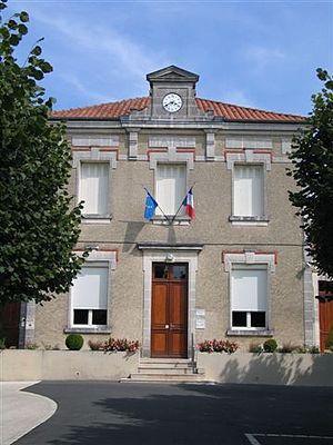
 Town hall (Mairie) of Sainte-Sévère |
||
Sainte-Sévère is a southwestern French community with 524 inhabitants (as of January 1 2017) in the Charente in the region Nouvelle-Aquitaine . The municipality belongs to the arrondissement of Cognac and the canton of Jarnac . The inhabitants are called Sévériens .
location
Sainte-Sévère is about nine kilometers northeast of Cognac . Sainte-Sévère is surrounded by the neighboring communities of Bréville in the north and north-west, Ballans in the north, Macqueville in the north-east, Houlette in the east, Réparsac in the south and Cherves-Richemont in the west and south-west.
Population development
| year | 1962 | 1968 | 1975 | 1982 | 1990 | 1999 | 2006 | 2017 |
| Residents | 466 | 474 | 499 | 509 | 578 | 550 | 542 | 524 |
| Sources: Cassini and INSEE | ||||||||
Attractions
- Sainte-Sévère church, built in 1896/1897
- Remains of a Roman camp
Web links
Commons : Sainte-Sévère - Collection of images, videos and audio files

