
Chantillac
| Chantillac | ||
|---|---|---|
|
||
| region | Nouvelle-Aquitaine | |
| Department | Charente | |
| Arrondissement | cognac | |
| Canton | Charente Sud | |
| Community association | 4B Sud Charente | |
| Coordinates | 45 ° 19 ′ N , 0 ° 15 ′ W | |
| height | 65-151 m | |
| surface | 18.05 km 2 | |
| Residents | 332 (January 1, 2017) | |
| Population density | 18 inhabitants / km 2 | |
| Post Code | 16360 | |
| INSEE code | 16079 | |
 Town Hall (Mairie) of Chantillac |
||

Chantillac is a western French community with 332 inhabitants (as of January 1 2017) in the department of Charente in the region Nouvelle-Aquitaine (before 2016 Poitou-Charentes ). The municipality belongs to the Arrondissement of Cognac and the canton of Charente-Sud ( Baignes-Sainte-Radegonde until 2015 ). The inhabitants are called Chantillacais .
location
Chantillac is located about 52 kilometers southwest of Angoulême . Chantillac is surrounded by the neighboring communities of Bran in the north, Baignes-Sainte-Radegonde in the north and north-east, Bors (Canton de Charente-Sud) in the east, Chevanceaux in the south and south-east, Chatenet in the south and south-west, Le Pin in the west and south-west, Mérignac in the west and Messac and Vanzac in the northwest.
Population development
| year | 1962 | 1968 | 1975 | 1982 | 1990 | 1999 | 2006 | 2017 |
| Residents | 434 | 451 | 410 | 332 | 319 | 277 | 279 | 332 |
| Sources: Cassini and INSEE | ||||||||
Attractions
- Saint-Jean-Baptiste church from the 12th century
- Monumental cross from the 14th / 15th centuries Century, monument historique since 1990
- 18th century mansion

Saint-Jean-Baptiste church
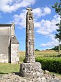
Monumental cross

