
Passirac
| Passirac | ||
|---|---|---|
.svg)
|
|
|
| region | Nouvelle-Aquitaine | |
| Department | Charente | |
| Arrondissement | cognac | |
| Canton | Charente Sud | |
| Community association | 4B Sud Charente | |
| Coordinates | 45 ° 21 ′ N , 0 ° 4 ′ W | |
| height | 74-174 m | |
| surface | 14.67 km 2 | |
| Residents | 240 (January 1, 2017) | |
| Population density | 16 inhabitants / km 2 | |
| Post Code | 16480 | |
| INSEE code | 16256 | |
 Town hall (Mairie) of Passirac |
||

Passirac is a western French community with 240 inhabitants (as of January 1 2017) in the department of Charente in the region Nouvelle-Aquitaine (before 2016 Poitou-Charentes ). The municipality belongs to the arrondissement of Cognac and the canton of Charente-Sud (until 2015: Brossac ). The inhabitants are called Passiracais .
location
Passirac is located about 34 kilometers south-southwest of Angoulême . Passirac is surrounded by the neighboring communities of Chillac in the north and west, Berneuil in the north, Sainte-Soline in the northeast, Châtignac in the east, Brossac in the east and southeast and Guizengeard in the southwest.
Population development
| year | 1962 | 1968 | 1975 | 1982 | 1990 | 1999 | 2006 | 2013 |
| Residents | 379 | 341 | 287 | 242 | 217 | 227 | 241 | 231 |
| Source: Cassini and INSEE | ||||||||
Attractions
- Saint-Pierre church from the 12th century, monument historique since 1991
- Châtelard Castle

Saint-Pierre church
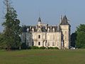
Châtelard Castle


Web links
Commons : Passirac - collection of images, videos and audio files