
Saint-Aulais-la-Chapelle
| Saint-Aulais-la-Chapelle | ||
|---|---|---|
|
||
| region | Nouvelle-Aquitaine | |
| Department | Charente | |
| Arrondissement | cognac | |
| Canton | Charente Sud | |
| Community association | 4B Sud Charente | |
| Coordinates | 45 ° 27 ′ N , 0 ° 3 ′ W | |
| height | 60–128 m | |
| surface | 14.84 km 2 | |
| Residents | 233 (January 1, 2017) | |
| Population density | 16 inhabitants / km 2 | |
| Post Code | 16300 | |
| INSEE code | 16301 | |
 Town hall (Mairie) of Saint-Aulais-la-Chapelle |
||

Saint-Aulais-la-Chapelle is a French commune with 233 inhabitants (as of January 1, 2017) in the Charente department . The municipality belongs to the arrondissement of Cognac and the canton of Charente-Sud (until 2015: canton of Barbezieux-Saint-Hilaire ).
geography
Saint-Aulais-la-Chapelle is located about 27 kilometers southwest of Angoulême .
The neighboring communities are Saint-Bonnet in the north and north-west, Angeduc in the north, Val des Vignes in the north-east, Coteaux-du-Blanzacais in the east, Bessac in the south-east, Brie-sous-Barbezieux in the south and Challignac in the west and south-west.
Population development
| year | 1962 | 1968 | 1975 | 1982 | 1990 | 1999 | 2006 | 2013 |
|---|---|---|---|---|---|---|---|---|
| Residents | 372 | 350 | 325 | 294 | 264 | 233 | 243 | 233 |
| Sources: Cassini and INSEE | ||||||||
Attractions
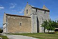
- Saint-Jacques church in Conzac, monument historique since 1953
- Sainte-Eulalie church in Saint-Aulais
- Saint Vincent Church in La Chapelle

Saint-Jacques church
Sainte-Eulalie church

Saint Vincent Church


Web links
Commons : Saint-Aulais-la-Chapelle - Collection of images, videos and audio files