
Condéon
| Condéon | ||
|---|---|---|
|
||
| region | Nouvelle-Aquitaine | |
| Department | Charente | |
| Arrondissement | cognac | |
| Canton | Charente Sud | |
| Community association | 4B Sud Charente | |
| Coordinates | 45 ° 24 ′ N , 0 ° 8 ′ W | |
| height | 63-161 m | |
| surface | 31.4 km 2 | |
| Residents | 607 (January 1, 2017) | |
| Population density | 19 inhabitants / km 2 | |
| Post Code | 16360 | |
| INSEE code | 16105 | |
 City Hall (Mairie) of Condéon |
||

Condéon is a western French community with 607 inhabitants (at January 1, 2017) in the department of Charente in the region Nouvelle-Aquitaine (before 2016 Poitou-Charentes ). It belongs to the Arrondissement of Cognac and the canton of Charente-Sud ( Baignes-Sainte-Radegonde until 2015 ). The inhabitants are called Condéonais .
location
Condéon is located about 42 kilometers southwest of Angoulême in the cultural landscape of the Angoumois . This is where the lary arises . Condéon is surrounded by the neighboring communities of Reignac in the north and west, Salles-de-Barbezieux in the north, Challignac in the north-east, Berneuil in the east, Chillac in the south-east, Oriolles in the south, Touvérac in the south-west and Le Tâtre in the west and south-west.
Population development
| year | 1962 | 1968 | 1975 | 1982 | 1990 | 1999 | 2006 | 2017 |
| Residents | 621 | 603 | 533 | 518 | 553 | 540 | 550 | 607 |
| Sources: Cassini and INSEE | ||||||||
Attractions
- Saint-Marien church from the 11th century, monument historique since 1913
- Windmill
- moth
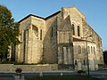
Saint-Marien church

Windmill

