
Monte Chiampon
| Monte Chiampon (Cjampon) | ||
|---|---|---|
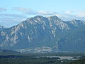
 Randalpine valley funnel of the Tagliamento near Gemona : The double-peaked rock massif is the Chiampon, behind it on the left the Plauris massif |
||
| Highest peak | Monte Chiampon / Cjampon ( 1709 m slm ) | |
| location | Friuli Venezia Giulia , Italy | |
| part of | Julian Prealps , Julian Alps | |
|
||
| Coordinates | 46 ° 17 '40 " N , 13 ° 10' 52" E | |

The Monte Chiampon ( Italian , Furlanisch Cjampón ) is a 1709 m slm high mountain massif on the edge of the Alps in Friuli . It is located near Gemona and belongs to the Julian Pre-Alps .
geography
Location and landscape
The mountain lies on the edge of the southern Alps to the northern Italian plain , between the valley of the Tagliamento near Gemona to the west and the upper reaches of the Torre near Tarcento to the east. The landscape of the mountain looks mighty, it rises a good 1,500 meters above the northern Italian lowlands beginning at its foot , which is here at about 200 meters above sea level.
The Chiampon massif is karstified and rugged to the south and north, the foothills and mountain feet softer and wooded. Gemona itself lies at the foot of the rubble of the mountain ( Torrente Veliato ) at around 270 m slm
Classification, demarcation and neighboring mountain groups
The massif belongs to the Northern Julian Prealps , which extend between the Eisental (Canal del Ferro , lower Fella ) and upper Natisone / Nadiža in the Italian-Slovenian border area. The massif is either combined with the east adjoining Gran Monte - Stol -Zug to form a fringe alpine group Chiampon-Stol ( SOIUSA ), orographically more compact to the northern group Plauris - Musi , or in terms of landscape to the Prealpi del Torre (Plauris-Gran Monte).
Boundary
- In the west of the Tagliamento from Gemona del Friuli to Venzone : to the Verzegnis - Piombada group (SOIUSA C.9.a of the Valcalda – Verzegnis chain ) of the Venetian Alps ( Carnic Pre-Alps )
- In the north Valle della Venzonassa - Forcella la Tacia ( 1087 m slm ) - Rio Vodizza near Musi : to the Plauris – Musi train (SOIUSA 34.2.I)
- In the east, Torre to Tarcento : to Gran Monte ( [Gran Monte–] Stol-Zug , SOIUSA 34.2.II)
- In the south Tarcento - Gemona (by a good 200 m slm ): to the north Italian plain (Pianura Padana)
The southern foothills of the massif are already counted as part of the Friuli hill country (Friuli collinare) .
Outline and summit

The two main peaks are:
- Monte Chiampon ( Cjampón , 1709 m slm ) itself, the more easterly peak
- Monte Deneal ( Deneâl , 1703 m slm ), the more western peak
To the east the main ridge stretches out (among other things) in:
- Faeit ( 1636 m slm ) and Ambruseit ( Ambrusêt , 1640 m slm )
- Cuel de Lanis ( 1629 m slm ) and Monte Laschiplas ( 1612 m slm )
To the south is upstream, somewhat separated by the Torre sub -valley of the Torrente Vedronza and the Veliato near Gemona, via Magnano in Riviera and Artegna and around the valley of Montenars , separated by the Sella Foredor (Foredôr) ( 1089 m slm ):
- Monte Cuarnan ( 1372 m slm ) with numerous low foothills
Northwest towards Venzone, separated by the Forca de Ledis ( 758 m slm ):
- Monts di Ledis (Lèdis) with Monte Ledis ( 1055 m slm )

Northern flank of the Bordano massif : Chiampon – Deneal on the right, Faeit – Lanis in the middle, Ledis on the left
The main floor above Gemona, from Pinzano al Tagliamento


Ascent and paths
The Alta Via CAI Gemona via ferrata (749, marked in 2011) runs over the main ridge of the Chiampon Stock . Approaches are possible from all valley locations, but the western flank is impassable. The mountain feet and foothills are easier hiking areas.
Web links
Individual evidence
- ↑ In Italian maps mostly without an apostrophe.
- ↑ a b c Cjampón e Lèdis. In: itinerari gemonese> Luoghi e cenni storici (on sites.google.com), accessed October 10, 2015.
- ↑ Sergio Marazzi: Atlante orografico delle Alpi: SOIUSA: suddivisione orografica internazionale unificata del sistema alpino. 2005, p. 309.
- ^ Friuli Venezia Giulia. Volume 8 of Guida d'Italia del Touring Club Italiano , 1982, p. 21 ( limited preview in the Google book search).
- ↑ a b Prealpi Giulie: 763 Alta Via CAI Gemona. sentiericai-fvg.it.
- ↑ Sella Foredor and Traversata del monte Chiampon since sella Foredor ai Rivoli Bianchi di Venzone. sentierinatura.it.
- ^ Alta via del CAI di Gemona. il ravanatore, February 7, 2011 - Tour description with photos, accessed October 10, 2015.