Northern Italian Plain
Coordinates: 45 ° 0 ′ N , 11 ° 0 ′ E
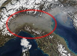
The Northern Italian Plain , also Northern Italian Plain (or also: Padan Plain ) is a large landscape of Italy . It is made up of the Po Valley ( Italian Pianura padana ) and then east of the plain in Friuli-Venezia Giulia ( Italian Pianura veneto-friulana ).
Location and landscape
The northern Italian plain extends along the interior of the Alpine arc and north of the Apennines to the Upper Adriatic .

Most of the landscape includes the Po plain , the coastal plains of Friuli and Veneto to the east and the Romagna plain to the north of the Apennines . Since one speaks generally of the “Po Valley” for the west ( Italian padana as an adjective to Po), the expression “Northern Italian Plain” is used especially in relation to the eastern part, where the coastal lowlands have no explicit landscape name. The catchment area of the Po as the main river of the area includes the area around Turin and Milan and stretches to Ferrara , the more general term also includes the plains from the lower Adige via Piave , Tagliamento and Isonzo in the area from Verona and Padua to Venice and Udine , as well the Reno river basin between Bologna and Ravenna and the smaller Apennine rivers to Rimini . Individual areas have names, such as the Veronese Plain (Bassa Veronese) .
Politically, the Po Valley belongs to the Italian regions of Piedmont , Lombardy , Emilia-Romagna , Veneto and Friuli-Venezia Giulia and, to a small extent, to the Swiss canton of Ticino .
The North Italian Plain forms the transition to the Italian Peninsula , it can therefore also be counted as Central Europe (Central Europe) - in the broadest sense of this term. The lower Po - Bormida line (roughly Venice - Piacenza - Alessandria - Savona ) also forms the border of the Alpine region , but today the entire northern Italian plain is seen as part of an extended Alpine region as a macro region . Both sides of the Po are also referred to as the Southern Alpine Foreland and the Northern Apennine Foreland . The Lega Nord party calls the region Padania today for political reasons in order to emphasize its independence, but this is not an official name.
The entire area is not the lowlands in the narrower sense, the Po reaches 100 meters above sea level at Casale west of Milan, but a good half of the area is gently rolling hills , especially in Piedmont, northern Lombardy and lower Friuli. The Apennines also have flat waves. Between Verona, Vicenza and Padua, with the Colli Berici and the Colli Euganei, there are even foothills of the Alps; they represent a certain natural division into a subalpine western and the Adriatic eastern part.
In a 50-kilometer-wide border on the Adriatic, it is already so flat that the borders of the river basins begin to blur, this stretch of land between the estuaries (some of which, like the Tagliamento, are dry torrentes ) of a dense network of Canals crisscrossed. The hydrographic delimitation of the catchment areas of the great Alpine rivers often runs directly on the banks.
The plain was formed since the Tertiary as part of the alpine mountain formation through erosion and sedimentation of the alpine rivers into the upstream geological depression of the upper Adriatic, which was alternately mainland and shallow sea. This molasse trough is partly filled with sediment several thousand meters deep .
Individual evidence
- ^ For example: Carl von Sonklar : Basic features of a hyetography of the Austrian imperial state. XV. in: Mitteilungen der Geographische Gesellschaft Wien , Volume 4, Verlag E. Hölzel, 1860, p. 209 (entire article 205 ff; Google eBook, complete view ).
- ↑ The lowlands around Verona / The Verona lowlands are a unique natural area. norditalien-magazin.de, accessed October 7, 2015.
-
↑ For example the extended alpine region. Eurac.edu;
Are drought periods becoming more frequent in the Alpine region? ZAMG, September 21, 2015. - ↑ Geo-Portal of the Ministry for the Environment, Landscape and Marine Protection, pcn.minambiente.it/viewer → Layer Bacini idrografici
