Monte Leupa
| Monte Leupa / Lopa | ||
|---|---|---|
|
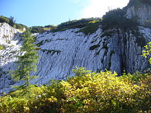
Krnica side of the Lopa (Slovenian southern flank) |
||
| height | 2403 m slm | |
| location | Italian-Slovenian border near Sella Nevea and Bovec | |
| Mountains | Kanine Group , Julian Alps | |
| Coordinates | 46 ° 22 '13 " N , 13 ° 29' 39" E | |
|
|
||
| First ascent | Sendtner 1842 | |
| Development | Cable car Rif. Celso Gilberti –Golovec ( Kanin ski area ) | |
| particularities | 2402 m. i. J .; Mediterranean – Black Sea watershed | |
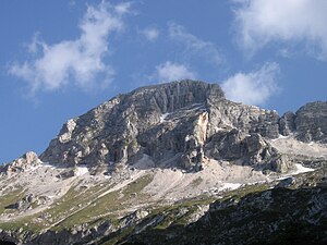
The Monte Leupa , Slovenian Lopa , is a 2403 m slm respectively 2,402 m. i. J. high summit of the Julian Alps on the Italian - Slovenian border south of the Sella Nevea ( 1195 m slm ) and above Bovec (Flitsch).
Location and landscape
The mountain lies between the Val del Rio del Lago (Seebachtal / Raiblertal ) of the Kanaltal (Val Canale) and Val Raccolana (Raccolana valley ) to the north, and the uppermost Soča valley (Dolina Soče, Isonzo valley), in the northeast ridge of the Kaning group , 15 kilometers southwest of Tarvisio (Tarvisio) and 6 kilometers northwest above Bovec.

The Leupa is a wide wall that looks like a pointed peak from the side. Below its north face is the sloping plateau Pala Celar , below is the Vordlapf Monte Poviz ( 1987 m slm ), which rises steeply as a rock head above the wooded valley slopes on the Nevea saddle . The west ridge of the Leupa ends in the Golovec (2285 m), and then breaks off steeply into the Sella Prevala (2062 m). Below the Golovec, on the Italian side, there is the Punta Medon ( 2124 m slm ) as a tooth in the plateau. The Kar Vršiči pod Lopu lies to the south of the Prevala saddle , and the southern flank of the Lopa slopes down into the Krnica valley on the Slovenian side . The northeast ridge of the Leupa lowers to the flat ridge of the Konjske Police (around 2297 m).
The main ridge of the Kanin group runs further west from Prevala into the glaciated Kanin main stock , over Monte Forat / Prestreljenik (2498 m) to the main peak Canin Alta / Visoki Kanin (2587 m), 4 kilometers to the east . It runs northeast to Monte Cergnala / Hudi Vršič (2344/43 m).
The Pala Celar drains from Monte Poviz northwards to the Rio del Lago (Seebach) and Lago del Predil (Raibler See), and further via Slizza / Gailitz to the Gail , but westwards to the Torrente Raccolana , which rises below the Prevala and at Chiusaforte- Raccolana in the Eisental flows to the Fella , a tributary of the Tagliamento . The dry channels Krničar – Gijun run south to the Soča between Bovec and Žaga (Saag). The Gail flows over the Drau / Drava to the Danube , Tagliamento and Soča / Isonzo flow into the Adriatic Sea . The summit thus belongs to the Mediterranean – Black Sea watershed . On the slopes below the Leupa there are numerous caves on the Neveapass.
History, development and ascent
As far as is known, the mountain was first climbed in 1842 by the botanist Sendtner.
After the loss of Venice, the border between Austria and Italy ran a little north at the Cima Confine on the Cergnala. The Alpine front of the First World War also ran there. The Monte Lopa was also expanded with supply lines.
To the west below, the Rifugio Celso Gilberti has stood at 1850 m slm since 1934. From there, a cable car was built up to Golovec in 2009, which enabled the connection to the cross-border ski area Kanin –Sella Nevea – Bovec .
The Monte Leupa itself is rarely climbed and is more demanding climbing.
Nature protection exists on the Slovenian side, there the mountain belongs to the Triglavski narodni park (Triglav National Park) , on the Italian side the Parco Naturale Prealpi Giulie (Julian Prealps Nature Park) begins beyond the Prevala saddle.
Web links
Individual evidence
- ↑ a b c d e Lopa (2402 m). In: Smeri V Primorskih Stenah , primorskestene.com, accessed October 9, 2015.
- ↑ Lopa. summitpost.org - views in particular about image 5 from the photo series and also Rif. Gilberti and Lopa (picture 1).
- ↑ Sella Ursic 2280 m. Mountain and ski touring site , feiersinger.jimdo.com, accessed October 9, 2015 - with several photos of the Italian side seen from the west.
- ↑ New ski area connects Italy and Slovenia. In: Madonna 24 , madonna.oe24.at, December 1, 2009.
-
↑ Kanin-Sella Nevea Ski Resort , boveckanin.si;
Sella Nevea - rabbit. , PhD, Agenzia Regionale Friuli Venezia Julia;
Kanin - Bovec - Sella Nevea ski area and Sella Nevea ski area. bergfex.at.

