
Monte dates
| Monte dates / V koncu špica | ||
|---|---|---|
 View of the end of the valley at the Lago di Fusine superiore (Upper Weißenfelssee): in the middle Veunca and diagonally right behind it Monte appointments; left Ponza and Strugova ; right Piccolo Mangart and Mangart-Ostgrat |
||
| height | 2350 m slm | |
| location | Italian-Slovenian border south of Thörl-Maglern | |
| Mountains | Mangart Group , Julian Alps | |
| Coordinates | 46 ° 26 '15 " N , 13 ° 41' 3" E | |
|
||
| particularities | 2351 m. i. J .; Mediterranean – Black Sea watershed | |

The Monte appointments , Slovenian V koncu špica is a 2350 m slm or 2351 m. i. J. high summit of the Julian Alps on the Italian - Slovenian border south of Thörl-Maglern .
Location and landscape

The mountain lies between the Val Romana (Weißenfelser Tal, Römertal) of the Kanaltal (Val Canale), the Planica of the uppermost Savetal (Slovenian Dolina Save) and the uppermost Sočatal (Dolina Soče, Isonzo valley), in the northern ridge of the Mangart group , 11 kilometers southeast of Tarvisio (Tarvisio), 9 kilometers southwest of Kranjska Gora and 15 kilometers northeast of Bovec .
The rocky peak rises inconspicuously in the rugged ridge. The main ridge runs eastward over the Forcella Sagherza / Zagerca (2150 m) to Piccolo Mangart di Coritenza / Mali Koritniški Mangart (2380 m), the easternmost peak of the Mangart massif (2677 m). To the north it continues over the Sella Veunca / Vevnica (2278 m) to Veunca / Vevnica (2340 m) and over Cima Strugova / Strugova špica (2265 m) and Ponza / Ponca (2275 m) to the Valico di Fusine / Rateče (Ratschacher Sattel, 850 m). The main ridge of the Julier leads south over the Kotova špica (2376 m) and the Kotovo sedlo (2138 m) to the Jalovec (2645 m)
In the north lies the largely waterless catchment area of the Rio del Lago , which goes over the Laghi di Fusine (Weißenfelser lakes), the place Fusine in Valromana and the Rio Bianco to Slizza / Gailitz and Gail . To the northeast is the also waterless high valley Tamar of the Planica valley , which drains in the depths to the Sava Dolinka , the upper reaches of the Save / Save . To the southwest is the Loška Kortnica high valley, the headwaters of the Kortnica , which flows into the Soča at Bovec . Gail (to the Drau / Drava ) and Save go to the Danube , Soča / Isonzo to the Adriatic . The summit thus belongs to the Mediterranean – Black Sea watershed .
That the mountain of the valley is of three valleys, it is the name, corridor V koncu ( 'In the end') is on the Sočaseite in Loška Kortnica directly below.

End of the valley on the Soča side, in the middle the Kotova špica , on the left the V koncu špica

Kotova špica (left) and V koncu špica (right) from the Tamar , the Hintertal of Planica
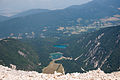
View of the Italian side, Laghi di Fusine and Valromana (here from Mangart)

View from V koncu špica over Kotova špica to Jalovec


.jpg)

Ascent
From the Italian side up for the way via Alpe Tamer and Rifugio Luigi Zacci to the Forcella Sagherza / Zagerca, where the Bivacco Alberto Busetti for Mangert ascents is located (Via della Vita) . A little below the path branches off into the Sella Veunca / Vevnica, which leads to the Ponza crossing (Via degli Alpini). From the Soča side, the path goes to Mangert and the bivouac box via V koncu. The east side of the Planica - Tamar is not marked, there is the Bivak na Kotovem sedlu on Jalovec . The summit itself can only be reached in high alpine terrain without a path, the Forcella Sagherza - Sella Veunca crossing is easier, the path over the Kotova špica exposed with climbing spots.
Exactly at the summit is the Italian-Slovenian border stone from the definition of the borders in the Treaty of Rapallo 1920.
Web links
Individual evidence
- ↑ a b 'Hinterster Berg'; V koncu 'Im / Am Ende' to konec , German would say 'Im Winkel' u. Ä .; špica is the borrowing of the German tip .
- ↑ Opposite direction to picture Jalovec ridge - Mangart above.
-
↑ Tour descriptions:
Kotova špica in V koncu špica September 17, 2011. Franci B., Franc P., PD Vrelec Rogaška - Planinsko društvo iz Rogaške Slatine, September 2011, accessed October 5, 2015 (illustrated);
Kotova špica - V Koncu špica - Vevnica: manj znane gore med Jalovcem in Mangartom - July 2, 2015. In: PrimožGrahelj's blog , July 3, 2015, accessed October 5, 2015 (illustrated);
V Koncu špica (2350 m) . Marijana & Marko, arnes.si, undated, accessed October 5, 2015;
Vevnica in V Koncu špica 18-08-2006. Photo gallery on mojalbum.com, accessed October 5, 2015. - ↑ Geographisch-Ethnologische Gesellschaft Basel, University of Basel - Geographical Institute (ed.): Cahiers de géographie jurassienne et rhénane . tape 21-23 . Verlag Helbing & Lichtenhahn, 1980, p. 204 ( limited preview in Google Book search).