
Moyobamba
| Moyobamba | ||
|---|---|---|
|
Coordinates: 6 ° 2 ′ S , 76 ° 58 ′ W Moyobamba on the map of Peru
|
||
| Basic data | ||
| Country | Peru | |
| region | San Martín | |
| province | Moyobamba | |
| Residents | 50,073 (2017) | |
| City insignia | ||
 |
 |
|
| Detailed data | ||
| height | 860 m | |
| Waters | Río Mayo | |
| Time zone | UTC -5 | |
| City Presidency | Gastelo Huaman Chinchay (2019-2022) |
|
| Website | ||
 |
||

Moyobamba is a city in northern Peru in the eastern foothills of the Andes . It had 50,073 inhabitants at the 2017 census. It is located in the district of Moyobamba province Moyobamba whose capital it is. It is also the administrative center of the San Martín region .
history
Moyobamba was founded on July 25th, 1540 by the Spaniard Don Juan Pérez de Guevara under the name “Santiago de los Ocho Valles de Moyobamba” and is therefore the oldest city in the Peruvian Amazon region. But even before this city was founded, indigenous villages existed in the same place . In 1897 Moyobamba became the capital of the Loreto department, until the San Martín department was founded in 1906, and Moyobamba is still the capital today.
Moyobamba was the seat of the Maynas diocese from 1812 to 1843 . Since 1948 Moyobamba has been the seat of the Territorial Prelature of Moyobamba .
geography
The city is 860 meters above sea level and has a subtropical climate. The temperatures fluctuate between 18 and 28 ° C with an annual average temperature of 24 ° C. The rainy season is from December to March. During this time, the roads around Moyobamba are often hardly passable.
On September 26, 2005, an earthquake with a magnitude of 7 to 7.5 on the Richter scale struck 90 kilometers north of Moyobamba. The city was badly damaged and several people were killed.
Economy and Transport
Moyobamba is an important traffic junction, as the city lies on the 2677 km long national road 5 ( Ruta nacional PE-5), better known as Longitudinal de la Selva , formerly also called Carretera Marginal de la Selva . It leads on the one hand, in the south-eastern course, via Tarapoto to Yurimaguas into the Amazon basin and, on the other hand, in the north-western course, is connected to the national roads 1 and 3. Until the 1990s, it was one of the few roads that crossed the Andes and connected the Peruvian lowlands with the Pacific coast. Moyobamba therefore sees itself as the “gateway to the Amazon”. This highway caused and continues to cause strong population and economic growth in the city.
sons and daughters of the town
- Los Mirlos , famous cumbia music group
gallery

Plaza de Armas
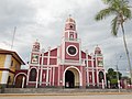
cathedral
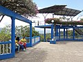
At the Punta Tahuishco viewpoint

Waqanki Orchid Garden

San Mateo thermal baths


Web links
Individual evidence
- ^ Peru: San Martín Region - Provinces & Places . www.citypopulation.de. Retrieved December 23, 2019.
- ↑ Instituto Nacional de Estadística e Informática (INEI): Directorio Nacional de Centros Poblados - Censos Nacionales 2017 . Lima 2018, vol. 4, p. 1731 ( online ).
- ^ Conferencia Episcopal Peruana: Directorio Eclesiástico 2002 . CEP, Lima 2002, p. 896.