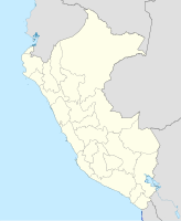
Tarapoto
| Tarapoto | ||
|---|---|---|
|
Coordinates: 6 ° 29 ′ S , 76 ° 22 ′ W Tarapoto on the map of Peru
|
||
| Basic data | ||
| Country | Peru | |
| region | San Martín | |
| province | San Martín | |
| City foundation | 1782 | |
| Residents | 74,804 (2017) | |
| - in the metropolitan area | 141.713 | |
| City insignia | ||
| Detailed data | ||
| height | 356 m | |
| Waters | Río Shilcayo | |
| Time zone | UTC -5 | |
| City Presidency | Tedy del Águila Gronerth (2015-2018) |
|
| Collage of image views from Tarapoto | ||
Tarapoto is a city in the South American state of Peru at the foot of the Andes . It is the economic center of the province of San Martín , although Moyobamba is the capital of the province.
With 74,804 inhabitants (2017 census), Tarapoto is the largest city in the Peruvian region of San Martín . The city is on the Longitudinal de la Selva road, which leads from the Pacific coast via Moyobamba to Yurimaguas in the Amazon basin . There is also an airport with connections to Lima and Iquitos .
Attractions
- Museo Regional de la Universidad Nacional de San Martín
- Centro Urku de Estudios Amazónicos
Sons and daughters
- César Villanueva (* 1946), politician
climate
Tarapoto is 250 to 500 meters above sea level and has a tropical climate . The rainy season is from December to March. During this time, the streets around Tarapoto are often hardly passable.
|
Average monthly temperatures and precipitation for Tarapoto (1961–1990)
Source: NOAA
|
|||||||||||||||||||||||||||||||||||||||||||||||||||||||||||||||||||||||||||||||||||||||||||||||||||||
Web links
Commons : Tarapoto - collection of images, videos and audio files
- City website (Spanish, English)
Individual evidence
- ↑ PERU: San Martín Region - Provinces & Places . www.citypopulation.de. Retrieved December 28, 2019.
- ↑ Urku Centro de Estudios Amazónicos , accessed December 4, 2019.
- ↑ Tarapoto Climate Normals 1961–1990. National Oceanic and Atmospheric Administration , April 2015, accessed April 13, 2015 .


