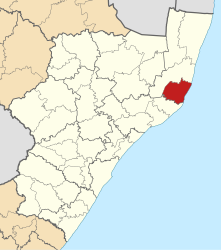
Mtubatuba (municipality)
| Mtubatuba Mtubatuba Local Municipality |
||
|---|---|---|
 |
||
| Symbols | ||
|
||
| Basic data | ||
| Country | South Africa | |
| province | KwaZulu-Natal | |
| District | Umkhanyakude | |
| Seat | Mtubatuba | |
| surface | 1970 km² | |
| Residents | 175,425 (October 2011) | |
| density | 89 inhabitants per km² | |
| key | KZN275 | |
| ISO 3166-2 | ZA-KZN | |
| Website | www.mtubatuba.org.za (English) | |
| politics | ||
| mayor | Q. Mkhwanazi | |
| Political party | Inkatha Freedom Party | |
Coordinates: 28 ° 25 ′ S , 32 ° 11 ′ E
Mtubatuba ( English Mtubatuba Local Municipality ) is a municipality in the South African district of Umkhanyakude in the province of KwaZulu-Natal with its seat in Mtubatuba . Christopher George Swartz is the mayor. The IFP provides the minority government in the local council.
The parish covers an area of 1970 square kilometers. 80% of the territory is tribal ownership.
The community is named after the Zulu clan chief Nkosi Mtubatuba from the Mkhwanazi clan.
geography
Mtubatuba is located in the east of KwaZulu-Natal on the coast of the Indian Ocean . It is approximately 200 kilometers south of the community to Durban and approximately 55 along the N2 to Richards Bay .
There are many natural bodies of water, wetlands, and native forests in the municipality. The groundwater is of high quality.
places
history
The first settlement in the area of the municipality can already be proven for the Iron Age . Several places with settlements from the early and late Iron Age have been found in the Dukuduku Forest.
The more recent history of the community and the city began as a train station and as the intersection of the old main road from Durban to eGolela on the border with Swaziland and the road to the St. Lucia Estuary. The government later set up a missile test base on the Nibela Peninsula, and during World War II there was an Air Force base in Catalina Bay. After the Second World War, the then government offered some soldiers who had fought in North Africa and Italy land so that they could support themselves. It was started to grow sugar cane in particular.
Over time, more and more people settled in this area, so new settlements had to be planned. In the years that followed, the government made more and more efforts to protect the coastal forests, which have now been recognized as a World Heritage Site. In 1998 the provincial government in KwaZulu-Natal decided that the 700 families living in the Dukuduku Forest should be relocated. Two farms were bought and a new settlement was built for the families. However, the local administration turned itself across, as the opponents of the resettlement became stronger. In 2008 around 3200 families lived in the forest areas.
population
In 2011 the community had 175,425 inhabitants. Of these, 98.1% were black and 1% white.
The first language was 92.4% isiZulu , 2.9% English and 1.3% isiNdebele .
economy
The community's starting position for a healthy economic situation is poor: A large part of the population lives in scattered settlements or on rural farms. These rural areas are only accessible via poor quality roads. Otherwise there are problems with the infrastructure. For example, the water and wastewater supply and waste disposal must be expanded.
Agriculture
In Mtubatuba, the economy is largely based on agriculture. The main products are timber and sugar. There's a sugar mill in River View .
tourism
The nature of the municipality lends itself to ecotourism : the close proximity to the iSimangaliso Wetland Park - the main entrance to the park is in Mtubatuba - and the wetland of the estuaries of the Mkuze , Nyalazi and Hluhluwe rivers .
Web links
- Side of the community. at www.mtubatuba.org.za
- The Local Government Handbook: Mtubatuba Local Municipality (KZN275) . on www.localgovernment.co.za
- Top Business Portfolio: Mtubatuba Local Municipality - Year Round Action . on www.kzntopbusiness.co.za
- Integrated Development Plan: Second Review 2008–2009 - Section A (IDP Section A) ( English , PDF; 250 kB) Mtubatuba Municipality. Retrieved February 20, 2010.
Individual evidence
- ↑ Contact information: Mtubatuba Local Municipality ( English ) Archived from the original on July 31, 2010. Info: The archive link has been inserted automatically and has not yet been checked. Please check the original and archive link according to the instructions and then remove this notice. Retrieved February 7, 2010.
- ^ The Local Government Handbook - A complete guide to municipalities in South Africa. Mtubatuba Local Municipality (KZN275). Yes! Media, accessed December 26, 2016 .
- ↑ https://municipalities.co.za/overview/1094/mtubatuba-local-municipality
- ↑ a b http://www.statssa.gov.za/?page_id=993&id=mtubatuba-municipality
- ↑ South African Language - Place Names ( English ) Retrieved on 19 February, 2010.
- ↑ a b c d KZN Top Business
- ↑ IDP Section A; Pp. 6-8.
- ↑ IDP Section A; P. 9.
