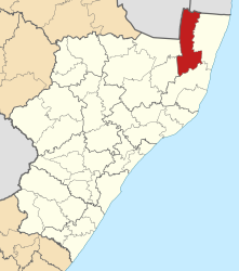
Jozini (Municipality)
| Jozini Jozini Local Municipality |
||
|---|---|---|
 |
||
| Symbols | ||
|
||
| Basic data | ||
| Country | South Africa | |
| province | KwaZulu-Natal | |
| District | Umkhanyakude | |
| Seat | Jozini | |
| surface | 3442 km² | |
| Residents | 186,502 (October 2011) | |
| density | 54 inhabitants per km² | |
| key | KZN272 | |
| ISO 3166-2 | ZA-KZN | |
| Website | www.jozini.org.za (English) | |
| politics | ||
| mayor | Delani Mabika | |
| Political party | Inkatha Freedom Party | |
Coordinates: 27 ° 26 ' S , 32 ° 4' E
Jozini ( English Jozini Local Municipality ) is a municipality in the South African district of Umkhanyakude in the province of KwaZulu-Natal . The administrative seat is Jozini . Mayor is Thembeni Petty Mthethwa. The IFP provides the minority government in the local council. Jozini is an isiZulu word and denotes a cave in which spears can be hidden.
The parish covers an area of 3442 square kilometers. 89% of the territory is tribal.
geography
Jozini is in the north of KwaZulu-Natal and borders on Swaziland and Mozambique . Partly located in the Lebombo Mountains and partly in the Makhatini Plain, the landscape is varied.
places
- Gingwavuma
- Jozini
- Cap
population
In 2011 the community had 186,502 inhabitants. 99.2% of them were black.
The first language was 94.6% isiZulu , 1.2% English and 1.1% isiNdebele .
economy
Large parts of the community belonged to the homeland KwaZulu until 1994 . Therefore, the economic development in rural Jozini has lagged. Many residents are unemployed.
Agriculture is an important pillar of the community. With the help of the Pongolapoort reservoir , 80,000 hectares of agricultural land are irrigated. Among other things, sugar cane, rice, coffee and cotton are grown.
However, the community has good prerequisites for future development: There are good transport links through the N2 . The area is also ideal for the expansion of tourism (see sights and activities ).
Sights and activities
- Lebombo Mountains
- Pongolapoort Reservoir (also known as Jozini Dam )
- Pongolapoort game reserve
- Mkuze game reserve
- Ndumu Game Reserve
- Hlatikulu Forest: a wooded area in the Lebombo Mountains
- Jozini Dam Development : Resort and Conference Center
- Border Cave : a rock canopy on the border with Swaziland. Objects and skeletons from the Middle and Late Stone Age have been found here.
- Fishing in the Pongola River
- King Dingane's tomb
- Usuthu Gorge
Web links
- Side of the community. at www.jozini.org.za (English)
- The Local Government Handbook: Jozini Local Municipality (KZN272) . on www.localgovernment.co.za (English)
- Top Business Portfolio: Jozini Local Municipality - Land of Plenty . on www.kzntopbusiness.co.za (English)
Individual evidence
- ↑ Contact information: Jozini Local Municipality ( English ) Archived from the original on July 31, 2009. Info: The archive link was inserted automatically and has not yet been checked. Please check the original and archive link according to the instructions and then remove this notice. Retrieved January 29, 2010.
- ^ The Local Government Handbook - A complete guide to municipalities in South Africa. Jozini Local Municipality (KZN272). Yes! Media, accessed December 26, 2016 .
- ↑ South African Language - Place Names ( English ) Retrieved on January 29 of 2010.
- ↑ a b Jozini at localgovernment.co.za (English), accessed on January 6, 2016
- ↑ a b http://www.statssa.gov.za/?page_id=993&id=jozini-municipality
