
Muasdale
|
Muasdale Scottish Gaelic Muasdal |
|||
|---|---|---|---|
 |
|||
| Coordinates | 55 ° 36 ′ N , 5 ° 41 ′ W | ||
|
|||
| Residents | 73 (1961 census) | ||
| administration | |||
| Post town | TARBERT | ||
| ZIP code section | PA29 | ||
| prefix | 01583 | ||
| Part of the country | Scotland | ||
| Council area | Argyll and Bute | ||
| British Parliament | Argyll and Bute | ||
| Scottish Parliament | Argyll and Bute | ||

Muasdale ( Gaelic : Muasdal ) is a small town in the Scottish Council Area Argyll and Bute . It is located on the west coast of the sparsely populated Kintyre Peninsula at the southern end of Gigha Sound about 20 kilometers northwest of Campbeltown and 33 kilometers southwest of Tarbert . Opposite is the island of Cara . In 1961 there were 73 inhabitants in Muasdale. The town is no longer listed separately in more recent census data. In Muasdale the stream Clachaig Water flows into the sea, which flows out of the Loch na Naich in the center of Kintyre .
traffic
The village is located directly on the A83 , which connects the Kintyre peninsula to the Central Belt . Although the west coast of Kintyre in particular was only sparsely populated in the past, a route through Muasdale existed as early as 1750 that proved to be significant enough to be included in William Roy's map series. The road bridge in Muasdale was recently renewed, replacing an old arched bridge over Clachaig Water. In the northern neighboring town of Tayinloan there is a ferry pier to the island of Gigha .
Attractions
North of Muasdale, on a hilltop, are the remains of a dun called Dun Domhnuill . This measured 15 m × 7.5 m, but is largely destroyed today. To the east of the village is a stone with cup-and-ring markings . On the coast between Muasdale and Tayinloan is the Killean and Kilchenzie Parish Church, a monument from the highest Scottish monument category A. The church building, built in 1791 in Georgian style , is still in use today.

The old arch bridge over Clachaig Water
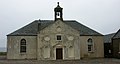
Killean and Kilchenzie Parish Church

Coast at Muasdale


Individual evidence
- ↑ a b Entry in the Gazetteer for Scotland
- ^ Information from the Scottish Parliament
- ↑ a b Entry in the Gazetteer for Scotland
- ^ Maps by William Roy
- ↑ Entry on Dun Domhnuill in Canmore, the database of Historic Environment Scotland (English)
- ↑ entry to South Crubasdale in Canmore, the database of Historic Environment Scotland (English)
Web links
- Entry on Muasdale in Canmore, Historic Environment Scotland database