William Roy (General)
William Roy (born May 4, 1726 in Carluke , South Lanarkshire , Scotland , † July 1, 1790 in London ) was a British cartographer , officer , geodesist and archaeologist .
Life
His father was involved in property management as a factor , so that William Roy came into contact with maps and property surveys early on. As a youth he was probably employed as a map-maker on the Board of Ordnance at Edinburgh Castle , in any case he made an official map of the Battle of Culloden there in 1746 , with which the Jacobite revolts were put down.
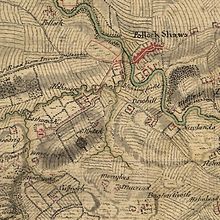
In order to better control the Scottish Highlands , King George II ordered their mapping, which was carried out by Roy and various soldiers under the orders of the Duke of Cumberland from 1747 to 1752 and then extended to the Lowlands until 1755 . These maps came to be known as The Duke of Cumberland's Map and commonly known as Roy's Map of Scotland .
The beginning of the Seven Years' War ended the further mapping of Scotland. Roy, who had been a civilian until then, became an army lieutenant and member of the Corps of Engineers and was commanded to the south of England to inspect the coastal defenses there in view of an expected French invasion. In doing so, he created plans of defensive structures and map sketches of various sections of the coast.
During the preparation for the Battle of Minden in 1759, he earned merit by summarizing the up to then common representation of the planned course of the battle on a series of individual sheets in a single plan, which significantly improved the overview of the planning. This method was then generally introduced. He himself quickly made a career afterwards.
After the war he returned to London. Even if the expected French invasion hadn't taken place, he advocated a nationwide survey. He was appointed Surveyor General in 1765, but after the cost of the previous war and the American Revolutionary War , there was no means of geodetic surveying.
Even while mapping Scotland he had noted traces of Roman settlements and forts and marked them on his maps. His interest in Roman antiquities remained until his time as Surveyor General. Many of his drawings of now lost Roman settlements are the only historical sources today.
In 1767 he became a member of the Royal Society . In the British Army in 1763 he became Lieutenant-Colonel and Director of the Royal Engineers. In 1777 he rose to colonel and finally to major-general in 1781 . From 1786 he was in command of the 30th (Cambridgeshire) Regiment of Foot .
In 1783, when he was already 57 years old, a new task arose completely unexpectedly. Cassini de Thury , the director of the Paris Observatory , raised doubts about the correctness of the coordinates of the Royal Greenwich Observatory in a memorandum and suggested connecting both observatories with a triangulation across the English Channel and thus establishing the correct position beyond any doubt. The memorandum was considered presumptuous in London, but George III. and Joseph Banks , President of the Royal Society, found the project useful when carried out with their own people. Roy was commissioned with the Anglo-French trigonometric survey , which he carried out between 1784 and (after three years of waiting for Jesse Ramsden's new theodolite ) 1790. For the first British baseline measured at Hounslow Heath, he was awarded the Copley Medal by the Royal Society .
After completing this survey, he died on July 1, 1790 in London.
With this survey he laid the basis for the British national survey that began after his death by the Ordnance Survey .
Web links
Individual evidence
- ^ Robert Hamilton Vetch: Roy, William (1726-1790) . In: Sidney Lee (Ed.): Dictionary of National Biography . Volume 49: Robinson - Russell. , MacMillan & Co, Smith, Elder & Co., New York City / London 1897, pp. 371 - 373 (English).
- ↑ Factor is the Scottish term for the property owner appointed manager
- ^ WA Seymour (Ed.): A History of the Ordnance Survey . Dawson, Folkestone 1980, ISBN 978-0-7129-0979-2 , pp. 62 (76 in PDF) ( ordnancesurvey.co.uk [PDF]).
- ↑ Edmund Burke (Ed.): The Annual Register For the Year 1790 . J. Dodsley, London 1793, p. 212 ( full text in Google Book Search).
| personal data | |
|---|---|
| SURNAME | Roy, William |
| BRIEF DESCRIPTION | British cartographer, officer, geodesist and archaeologist |
| DATE OF BIRTH | May 4, 1726 |
| PLACE OF BIRTH | Carluke |
| DATE OF DEATH | July 1, 1790 |
| Place of death | London |
