
Munichehausen

Munichehausen is a desolate, fallen settlement from the Middle Ages near Rehburg in Lower Saxony . The desert site is located on arable land south of Rehburg on the slope of the Haarberg, which is 87 m above sea level. Has NHN . The ancestral home of the von Münchhausen family was in Munichehausen .
history
In addition to the place name Munichehausen, numerous similar names have been handed down through historical sources, such as Munichusen (1155), Monechusen (1183), Monekehusen (1280), Monichusen (1314), Munchusen (1335), as well as Mönnekehusen, Mönkehusen and Mönchhusen. The name is based on the original property of the Loccum monastery at the location of the settlement. The place name is made up of the Middle Low German words monk for monk and -husen for -hausen and can be interpreted as Mönchhausen. In High German , this became the name Münchhausen for the noble family.
In 1155, according to a confirmation by Pope Hadrian IV, the Corvey Monastery held the manorial rule over the settlement. Around 1300 it was a fiefdom of the Bishop of Minden in the hands of the von Münchhausen family. In 1386 there is documentary evidence of a church in the settlement.
There are different traditions about the further history of the village. On the one hand, it is said to have been abandoned as early as 1350 when the residents moved to Rehburg. According to other sources, it was destroyed during the Hildesheim collegiate feud (1519–1523). The church was initially preserved until it was demolished in 1557. At an unknown point in time, the village was razed . The von Münchhausen family left Munichehausen in 1581 and moved into the completed moated castle in Brokeloh . The appearance and location of the von Münchhausen estate in Munichehausen is not known. It could have been a castle or a fortified building within the settlement or on the top of the Haarberg. On the hilltop, a Dutch anti- aircraft missile position of NATO was established in the mid-1960s during the Cold War . During the construction, there was considerable soil interference, which makes it difficult to search for archaeological remains.
Individual objects from the desert have been preserved to this day in the St. Martini church in Rehburg. This includes a cross above the pulpit , which is said to be part of the altar ceiling from the Münchhausen chapel. The almost 1000 kg baptismal font from the 12th century is also said to come from Munichehausen. In 1832 it was built into the foundations when a new rectory was built in Rehburg. In a new building in the 1960s, the baptismal font was rediscovered and stood for a long time as a flower pot on the market square before it was put back in the church.
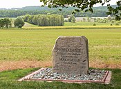
Memorial stone for Mönnekehusen (Munichehausen) on the eastern slope of the Haarberg; not at the actual desert location

View of arable land at the location of the desert
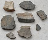
Gray-blue medieval pottery from arable land on the desert site
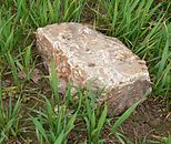
Hewn large-format stone in the area of the desert


Localization
The location of Munichehausen has not been passed down historically. The Kurhannoversche Landesaufnahme from the 18th century provides clues to the possible earlier location . A plaza-like area is drawn on it near the Haarberg between fields with paths leading from three directions. In 2000, the Rehburger Bürger- und Heimatverein erected a memorial stone for the settlement at an inaccessible place on the Haarberg, which was moved to a different location in 2015, a viewpoint above Winzlar. The settlement was not in either place.
The site of the desert was localized in 2016 by a volunteer from the archaeological preservation department . He made it based on the distribution of around 600 ceramic fragments, roughly estimated from the 13th to 15th centuries. He had recovered the artifacts made of gray-blue medieval ceramics during inspections on arable land on the northern slope of the Haarberg and georeferenced and mapped the sites . Due to the concentration of finds in a certain area, the desert site could be located. The volunteer archaeologist found a small, jewelry-like metal cross on the nearby parcel labeled Old Church . In addition, he found large-format stones with traces of processing in the area of the desert, which could be building material from Munichehausen.
It is planned to set up an information board and a bench at the desert site, which will allow a view of the former location of the church.
literature
- Ernst Messwarb: Münchhausen (Mönchhusen) in: From the Steinhuder Meer to the Weser. A contribution to the local history of Rehburg and the surrounding area , Stolzenau 1997, pp. 34–35.
- Münchhausen in: Geschichtliches Ortverzeichnis von Niedersachsen , Ed. Historical Commission for Lower Saxony and Bremen , pp. 417-418.
- Gudrun Husmeier: Münchhausen, Wüstung in: Geschichtliches Ortverzeichnis für Schaumburg , Schaumburger Studies, Vol. 68, Bielefeld 2008.
Web links
- Münchhausen's cradle in Stadtgeschichten Rehburg-Loccum from August 2012
- The old home of the Münchhausen family in Wunstorfer Stadtanzeiger from February 18, 2018 (on the ArchAN website)
Individual evidence
- ↑ St. Martini Church Rehburg at Mittelweser.de
- ↑ Beate Ney-Janßen: The village "Mönnekehusen" and the baron of lies in the district newspaper of May 11, 2013
- ↑ Beate Ney-Janßen: Baron von Münchhausen comes from the Haarberg in the district newspaper on April 1, 2015
- ↑ 600 shards are an indication in: Schaumburger Nachrichten of February 15, 2017
- ↑ Julia Kreykenbohm From Roman coins to barons of lies with a photo of the cross in the Kreiszeitung on February 13, 2017
- ^ The old home of the Münchhausen family in: Wunstorfer Stadtanzeiger from February 18, 2017
Coordinates: 52 ° 27 ′ 13 ″ N , 9 ° 13 ′ 47 ″ E