Municipio Felipe Carrillo Puerto
| Felipe Carrillo Puerto | ||
|---|---|---|

|
||
| Symbols | ||
|
||
| Basic data | ||
| Country | Mexico | |
| State | Quintana Roo | |
| Seat | Felipe Carrillo Puerto | |
| surface | 13,191.3 km² | |
| Residents | 75,026 (2010) | |
| density | 5.69 inhabitants per km² | |
| founding | 1975 | |
| Website | www.felipecarrillopuerto.gob.mx/ | |
| INEGI no. | 23002 | |
| politics | ||
| Presidente municipal | Gabriel Carballo Tadeo | |
| The former cathedral of Tihosuco | ||
Coordinates: 19 ° 30 ′ N , 88 ° 0 ′ W
Felipe Carrillo Puerto is a municipality in the Mexican state of Quintana Roo . The seat of the municipality is the eponymous Felipe Carrillo Puerto . The community had 75,026 inhabitants in 2010, its area is 13,191.3 km².
geography
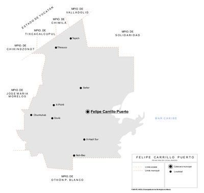
The municipality of Felipe Carrillo Puerto forms the geographic center of the state of Quintana Roo. It lies between sea level and 100 m altitude in the physiographic province of the Yucatán peninsula , 75% in its karst areas and 21% in the coastal region of Quintana Roos. Geologically, the municipality is dominated by limestone , the predominant soil type is the Leptosol . Over 75% of the municipality is occupied by rainforests.
The municipality of Felipe Carrillo Puerto borders on the municipalities of Solidaridad , José María Morelos and Bacalar as well as the state of Yucatán .
places
According to the 2010 census, the municipality Felipe Carrillo Puerto comprises 216 inhabited localidades , the INEGI classifies the main town Felipe Carrillo Puerto as well as Tihosuco, Chunhuhub, Señor and Tepich. In the 2010 census, twelve towns had a population of over 1,000.
| place | Residents |

|
| Felipe Carrillo Puerto | 25,744 | |
| Tihosuco | 4,994 | |
| Chunhuhub | 4,644 | |
| Señor | 3,095 | |
| Carpet | 2,753 | |
| Noh-Bec | 2,045 | |
| X-Hazil Sur | 1,422 | |
| X-Pichil | 1,340 | |
| Polyuc | 1,226 | |
| Dzulá | 1,223 | |
| Santa Rosa Segundo | 1,068 | |
| Presidente Juarez | 1.004 |
Web links
- Enciclopedia de los Municipios y Delegaciones de México: Municipio Felipe Carrillo Puerto (Spanish)
- INEGI : Datos Geográficos: Municipio Felipe Carrillo Puerto (Spanish; PDF)


