Municipio Sacaca
| Municipio Sacaca | ||
|---|---|---|
 Daybreak in the Municipio Sacaca |
||
| Basic data
|
||
| Population (state) - population density |
19,266 inhabitants (2012 census) 22 inhabitants / km² |
|
| Post Code | 05-0701 | |
| Telephone code | (+591) | |
| surface | 889 km² | |
| height | 3900 m | |
| Coordinates | 18 ° 6 ′ S , 66 ° 20 ′ W | |
|
|
||
| politics
|
||
| Department | Potosí | |
| province | Alonso de Ibáñez province | |
| Central place | Sacaca | |
 Location of the Municipio Sacaca in the Department of Potosí |
||
| climate | ||
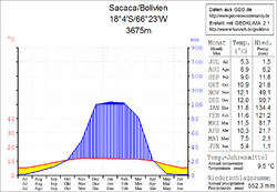
 Climate diagram Sacaca |
||
The Municipio Sacaca (also: Villa de Sacaca ) is a district in the Potosí Department in the South American Andean state of Bolivia .
Location in the vicinity
The Municipio Sacaca is one of two Municipios in the province of Alonso de Ibáñez . It is bordered to the west by the municipality of Caripuyu , to the north by the department of Cochabamba , to the northeast by the province of Bernardino Bilbao , to the southeast by the province of Charcas , and to the southwest by the province of Rafael Bustillo .
The central place of the district is Sacaca with 2,292 inhabitants ( 2012 census ) in the northern half of the municipality.
geography
The municipality of Sacaca is located east of the Bolivian Altiplano in the northern part of the Cordillera Central . The climate is a typical time of day climate in which the daily temperature fluctuations are greater than the seasonal fluctuations.
The annual precipitation is about 550 mm (see climate diagram Sacaca), with a distinct dry season from April to October with less than 20 mm monthly precipitation, and a short wet season in January and February with precipitation well over 100 mm. The mean average temperature of the region is 9.5 ° C and fluctuates only slightly between 50 ° C in June / July and 12 ° C in November / December.
population
The population of the Municipio Sacaca has increased by about a third in the past two decades:
- 1992 : 14,638 inhabitants ( census )
- 2001 : 18,725 inhabitants (census)
- 2012 : 19,266 inhabitants (census)
The life expectancy of newborns in the municipality is only 48 years, the literacy rate for those over 15 years of age is 60 percent ( 2001 ), and the proportion of the urban population in the municipality is 11.9 percent. ( 2012 )
politics
Results of the elections for the municipal council ( concejales del municipio ) in the regional elections on April 4, 2010:
| electoral legitimate |
electoral participation |
valid votes | MAS-IPSP | MOP | ||
|---|---|---|---|---|---|---|
| 7,762 | 6,767 | 4,926 | 4,045 | 881 | ||
| 87.2% | 72.8% | 82.1% | 17.9% |
structure
The municipality is divided into the following two cantons ( cantones ):
- 05-0701-01 Canton Sacaca - 170 localities - 18,919 inhabitants
- 05-0701-01 Canton Colloma - 1 village - 347 inhabitants
Localities in the municipality of Sacaca
- Sacaca Canton
- Sacaca 2292 pop - Tarwachapi 602 pop - Vila Vila 307 pop
- Canton of Colloma
- Colloma 347 pop.
Individual evidence
- ↑ Instituto Nacional de Estadística (INE) 1992
- ^ Instituto Nacional de Estadística (INE) 2001
- ↑ Instituto Nacional de Estadística (INE) 2012 ( Memento of the original of July 22, 2011 in the Internet Archive ) Info: The archive link has been inserted automatically and has not yet been checked. Please check the original and archive link according to the instructions and then remove this notice.
- ↑ Acta de computo Nacional Electoral Departamentales, Municipales y Regional 2010
Web links
- Municipio Sacaca - General Maps No. 50701
- Municipio Sacaca - detailed map and population data (PDF; 540 kB) ( Spanish )
- Department Potosí - social data of the municipalities (PDF 5.23 MB) ( Spanish )
