
Nanzhuang (Miaoli)
|
Nanzhuang 南 庄鄉 |
|||
.svg) Location of Nanzhuang in Miaoli County |
|||
| State : |
|
||
| County : | Miaoli | ||
| Coordinates : | 24 ° 33 ' N , 121 ° 1' E | ||
| Area : | 165.4938 km² | ||
| Residents : | 9,813 (Dec 2019) | ||
| Population density : | 59 inhabitants per km² | ||
| Time zone : | UTC + 8 (Chungyuan time) | ||
| Telephone code : | (+886) (0) 37 | ||
| Postal code : | 353 | ||
| ISO 3166-2 : | TW-MIA | ||
| Community type : | Rural community ( 鄉 , Xiāng ) | ||
| Structure : | 9 villages ( 村 , Cūn ) | ||
| Website : | |||
|
|||

Nanzhuang ( Chinese 南 庄鄉 , Pinyin Wǔfēng Xiāng ) is a rural community ( 鄉 , Xiāng ) in Miaoli County in the Republic of China (Taiwan) .
description
Nanzhuang (literally 'southern village') is located in the interior of the Miaoli district, about 10 to 15 km as the crow flies from the coast. The shape of the municipality is roughly similar to a rectangle with an edge length of 12.5 × 13.5 km with a pointed 5 km long tail to the west. The neighboring communities are in Miaoli Sanwan County in the northwest, Shitan in the southwest, Tai'an in the south, and in the adjacent Hsinchu Wufeng County in the east, Beipu and Emei , both in the north. The 492 m high Shitoushan ( 獅頭 山 , Shītóushān - "lion's head mountain " ) forms the natural border with Emei. Nanzhuang is characterized by mountainous land, with the average height above sea level increasing from northwest to southeast. There are only a few plains in the valleys. The largest flowing water is the Zhonggangxi ( 中港溪 , Zhōnggǎng xī , 溪 , Xī - "small river, brook"), the north of the 2616 m high mountain Luchangdashan ( 鹿場 大 山 , Lùchǎng dàshān - "Great Deer Field Mountain ", ) in the southeast corner Nanzhuang springs.
![]()
![]()
history
The original inhabitants of the area were the Saisiyat and Atayal tribes . In the first 1 ½ centuries of the Qing rule , the remote Nanzhuang was one of the "indigenous areas" in which Han Chinese were prohibited from permanent settlement. The ban was imposed by the Qing authorities in order to avoid conflicts with the warring tribes in the interior. The first permanent Han Chinese settlement was established in 1816 at the time of Daoguan's rule . After that, more and more Han Chinese settled in the country and the indigenous population was either assimilated or pushed further east. In the final stages of the Qing rule, Miaoli County was established in 1887, which then comprised a much larger area than it is today, and Nanzhuang became part of the county. At the time of the Japanese rule over Taiwan (from 1895) the area was systematically penetrated more and more administratively, with numerous disputes with the autochthonous population. In 1920 a major administrative reform took place and Nanzhuang was organized as a village in Zhunan County ( 竹 南郡 ) in Shinchiku Prefecture ( 新竹 州 ). In 1937, hard coal deposits were discovered in Nanzhuang, and mining began later. After the Republic of China took over Taiwan in 1945, the rural community ( 鄉 , Xiāng ) Nanzhuang was formed in 1946 . In 1950, Nanzhuang came to the newly established Miaoli County.
population
As in the rest of the Miaoli district, the population is largely made up of Hakka (approx. 80%). About 1.5% of the population is made up of Hoklo ( Min speakers). Members of indigenous peoples (mainly Atayal and Saysiat, the latter mainly in the villages of Donghe and Penglai) make up about 20%. (At the end of 2018, according to the official census, 2120 people). The population increased steadily after the Second World War and reached a peak in 1967 with 25,000. After that it decreased almost continuously.
| Outline of Nanzhuang |

|
Administrative division
As of 1946, Nanzhuang was divided into 10 villages. However, the village of Fengmei ( 風 美 村 ) was given up as a settlement in 1976 due to poor traffic accessibility and geological instability of the area and was administratively united with the neighboring village of Nanjiang. Since then, Nanzhuang has been divided into 9 villages ( 村 , Cūn ):
1 Yuanlin ( 員 林村 )
2 Nanfu ( 南 富 村 )
3 Shishan ( 獅山 村 )
4 Tianmei ( 田 美 村 )
5 Dong ( 東村 )
6 Bei ( 西村 )
7 Nanjiang ( 南 江村 )
8 Penglai ( 蓬萊 村 )
9 Donghe ( 東 河村 )
Transport links

_(Taiwan).jpg)

Nanzhuang is away from the major traffic routes. The only major road is County Road 124, which runs north to south on the western edge of Nanzhuang. Railway connections exist west of Nanzhuang in Zhunan and Toufen . There are also motorway connections to the west of Nanzhuang in Toufen ( National Road 1 ) and in Shitan and Sanwan ( National Road 3 ). In the far west, Provincial Road 3 briefly touches the area of Nanzhuang.
economy
Due to the low population density and the peripheral location of Nanzhuang, only a few commercial and industrial companies (electrical engineering, paper production) have settled. In earlier times, coal was mined in the area, but this was discontinued due to unprofitability. The main sources of income are agriculture and forestry. The economic use of the Nanzhuang forests began during the Japanese rule (from 1895). At that time camphor tree plantings were planted on a larger scale. In recent times, efforts have been made to use forest resources in a sustainable and conservation-friendly manner, which also aims to integrate the interests of the indigenous population. The municipal area comprises around 9000 ha of forest and around 1700 ha of agricultural land. Forst be economically especially spit Tannen , Phyllostachys reticulata (a bamboo type), tung oil trees planted, etc. and used. The state encourages farmers to cultivate agricultural products that are compatible with the mountainous topography and the ecology of the area. These include shiitake -Mushrooms, various vegetables, ornamental flowers, Stachys affinis ( "Chinese artichoke"), as well as Aspidistra elatior , an ornamental plant of the genus aspidistra , including by increasing economic importance of tourism.
particularities
The main attractions in Nanzhuang are in the area of nature. In addition, the culture of the indigenous population can be experienced. As part of the Shitou Mountains landscape area ( 獅頭 山 國家 山 , Shītóushān guójiā fēngjǐng qū ), Nanzhuang is primarily advertised for hiking tours. Some older streets in Nanzhuang are still well preserved and invite you to stroll through the streets. Shitoushan ( 獅頭 山 ) Mountain in Shishan Village is a tourist destination. There are several Taoist and Buddhist temples in the area, including the richly furnished Daoist Quanhua Temple ( 勸 化 堂 , Quànhuà táng , ), which is partially built into a natural rock cave and in which Yu Di , the "Jade Emperor" is venerated.
![]()
Other visitor destinations in Nanzhuang are z. For example, in the village of Dong the 154 m long Kangji suspension bridge ( 康 濟 吊橋 , ), a pedestrian bridge over the river valley of the eastern tributary of the Zhonggangxi and the historical “washing road”. Another pedestrian suspension bridge over the same river valley, the 166 m long Donghe Suspension Bridge ( 東河 吊橋 , ), lies further east in the village of Donghe. Also in Donghe is the Saysiyat Folk Museum ( 賽 夏 族 民俗 文物 館 on Xiangtan Lake ( 向天湖 ), ), built in 2002, which is dedicated to the Saysiyat culture.
![]()
![]()
![]()
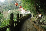
Path in Shishan Village
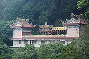
Buildings in Shishan

Rock formation
.jpg)
.jpg)

Web links
Individual evidence
- ↑ 獅頭 山 ("Shitoushan"). Nanzhuang website, accessed February 8, 2020 (traditional Chinese).
- ↑ 地理 概況 ("Geographical Profile"). Nanzhuang website, accessed February 8, 2020 (traditional Chinese).
- ↑ a b c 南庄 沿革 ("History of Nanzhuang"). Nanzhuang website, accessed February 8, 2020 (traditional Chinese).
- ↑ 楊文 山 (Yang Wenshan): 全國 客家 人口 基礎 資料 調查 研究 ("Basic data survey on the national Hakka population") . 2004, ISBN 957-01-9320-4 , Appendix: 鄉鎮 市區 臺灣 客家 人口 數 及 比例 (“Number and Proportion of the Taiwanese Hakka Population in Towns and Cities”) - (Chinese (traditional), online ).
- ↑ 族群 介紹 (“Introduction to the Ethnic Groups”). Nanzhuang website, accessed February 8, 2020 (traditional Chinese).
- ↑ 交通 概況 ("Traffic overview"). Nanzhuang website, accessed February 8, 2020 (traditional Chinese).
- ↑ 地理 概況: 地質 ("Geographical Profile: Geology"). Nanzhuang website, accessed February 8, 2020 (traditional Chinese).
- ↑ 經濟 發展 ("Economic Development"). Nanzhuang website, accessed February 8, 2020 (traditional Chinese).
- ↑ 南庄 地圖 導引 ("Map Instructions for Nanzhuang"). www.824296.com.tw, accessed February 8, 2020 (traditional Chinese).
- ^ Nanzhuang Old Street. www.travelking.com.tw, 2020, accessed February 8, 2020 (English).
- ↑ 觀光 導覽 (“guided tour”). Nanzhuang website, accessed February 8, 2020 (traditional Chinese).