Nasipit
| Municipality of Nasipit | ||
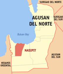
| Location of Nasipit in the Agusan del Norte province | ||
|---|---|---|

|
||
| Basic data | ||
| Region : | Caraga | |
| Province : | Agusan del Norte | |
| Barangays : | 19th | |
| District: | 2. District of Agusan del Norte | |
| PSGC : | 160209000 | |
| Income class : | 3rd income bracket | |
| Households : | 7010 May 1, 2000 census
|
|
| Population : | 41,957 August 1, 2015 census
|
|
| Population density : | 177.5 inhabitants per km² | |
| Area : | 236.36 km² | |
| Coordinates : | 8 ° 54 ′ N , 125 ° 19 ′ E | |
| Postal code : | 8602 | |
| Area code : | +63 85 | |
| Geographical location in the Philippines | ||
|
|
||
Nasipit is a municipality in the Philippines in the province of Agusan del Norte .
Nasipit is located 24 kilometers from the provincial capital Butuan City and 175 kilometers from the regional center of Cagayan de Oro .
The first written records of Nasipit date back to 1880, when the site was declared a pueblo by the Spanish . Nasipit became an independent municipality by decree of the US Governor General of the Philippines Eugene Allen Gilmore on August 1, 1929. Nasipit previously belonged to Butuan .
Barangays
Nasipit is politically divided into 19 barangays .
|
|
Web links
- www.nasipit.gov.ph ( Memento from June 13, 2009 in the Internet Archive )
