
Sandberge Oberweiden nature reserve

The nature reserve Sandberge Oberweiden south of Oberweiden in the Gänserndorf district in Lower Austria contains a sand flora that is unique in Austria and is one of the most important dry grasslands and one of the most valuable habitats in Austria.
geology
The area belongs to a strip of Pleistocene drifting sand that runs from Strasshof to Markhof and is part of the Gänserndorf terrace . The dune and drift sand areas of the Marchfeld were created during the last Ice Age and in the subsequent post- Ice Age . Fine sediment carried by the wind from the extensive sand and gravel banks of the rivers, especially the Danube , was deposited in the area of today's villages of Oberweiden, Weikendorf , Obersiebenbrunn , Lassee and Marchegg (Richtberg) and led to the formation of inland dunes . With the increase in temperature after the Ice Age, a denser vegetation cover could form again, which stabilized the sand. From the 10th and 11th centuries onwards, people cleared the soil, but permanent agricultural use was usually only possible for a short time due to the low fertility of the soil and entire villages were deserted again. Presumably, the areas were at least partially used as pastures .
Flora and fauna
Due to the weakly alkaline to weakly acidic reacting sand subsoil, which has only a small water capacity, and the centuries-long grazing, which resulted in a constant opening of soil areas, a sand flora could develop on the sand mountains that is unique in Austria. The Austrian dry grass catalog classifies the area as of national importance. After grazing was abandoned in the 20th century, the soil was stabilized and the number of pioneering societies decreased . In the Pannonian tragacanth Pfriemengrasflur there are still partially succession relics of open substrate steppe as the late carnation ( Dianthus serotinus ), the sand kochia ( Bassia laniflora ), the Everlasting flower ( Helichrysum arenarium ), the sand-thrift ( Armeria elongata ) , the panicle gypsophila ( Gypsophila paniculata ) and the vaginal sheep fescue ( Festuca vaginata ). The late carnation has its only occurrence in Austria in the sand mountains of Oberweiden. In areas with more dense grass , the gray silk feather grass ( Stipa pennata ) dominates and displaces the pioneer species. The dry grasslands are surrounded by protective forests and agricultural areas. Trees such as the black locust ( Robinia pseudoacacia ) and the tree of the gods ( Ailanthus altissima ) sometimes penetrate from there . The robinia, like all butterflies , accumulates nitrogen in the soil, fertilizes it and makes it colonizable for common species, which subsequently displace the rare, specialized species.
In the past, the sand mountains were also considered important from a faunal point of view and exhibited many rarities. However, due to the decline in open pioneer areas, the number of species has recently decreased.
protection
The nature conservation value of the sandy areas was recognized very late. On the contrary, from the reign of Maria Theresa, attempts were made to stabilize the areas by banning arable farming and grazing as well as afforestation, which was accompanied by the destruction of the sandy vegetation. First the trees needed for this were obtained from the nearby Danube floodplains . Since the species found there were not drought-resistant, however, there were high failures. It was not until the 19th and 20th centuries that permanent and large-scale afforestation took place. 1328 hectares were affected and only small remnants of the sandy vegetation remained. Only when it was largely too late was part of the inland dune area designated as a nature reserve Sandberge Oberweiden in 1961. Afterwards, too, there was illegal reforestation in other protected areas and forestry tried, with the help of media support and ignoring the nature conservation significance of the sand dunes, to create a mood against the "threatening desertification of the Marchfeld". The edge zones were repeatedly cut or damaged by pilling.
At the beginning of the 21st century, the nature reserve was included in the European protected area "Pannonian Sand Dunes". The area was enlarged by the municipality of Weiden an der March by 11 hectares, which means that the protected area now comprises 126 hectares. On the one hand, this enabled fields to be converted into sand lawns, and the resulting buffer zones also provide better protection against nutrient inputs from the wind. As a one-off maintenance measure, trees and shrubs were removed and the areas gained were sown with a locally obtained sand lawn mixture. As a recurring measure, the areas are regularly mowed by farmers and the soil is opened up in small areas with special tools.
photos
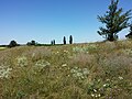
Dry vegetation on the Sandberg.
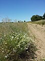
Sand path with late carnations south of the sand mountain.

View from the Sandberg to the south.
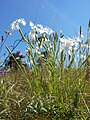
Late carnation ( Dianthus serotinus ), threatened with extinction in Austria.
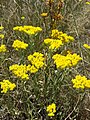
Sand straw flower ( Helichrysum arenarium ), endangered in Austria.

Panicle gypsophila ( Gypsophila paniculata ), endangered in Austria.


Individual evidence
- ↑ Geologische Bundesanstalt (Ed.): Geological Map of Lower Austria 1: 200,000, Lower Austria North , Vienna 2002
- ↑ a b Heinz Wiesbauer (Ed.): The steppe lives, rock steppes and dry grasslands in Lower Austria , St. Pölten 2008, ISBN 3-901542-28-0 , p. 70f Archived copy ( Memento of the original from February 19, 2014 on the Internet Archive ) Info: The archive link was inserted automatically and has not yet been checked. Please check the original and archive link according to the instructions and then remove this notice. (PDF; 775 kB)
- ↑ a b Federal Environment Agency (ed.): Nature conservation in the Pannonian region, sand dunes as living space , Illmitz 1997, ISBN 3-85457-497-5 , p. 10, 19ff [1] (PDF; 886 kB)
- ↑ a b Office of the Lower Austrian Provincial Government (Ed.): European Protected Areas "Pannonian Sand Dunes" and "Sand Soil and Praterterrasse", information on Natura 2000 management for the FFH and bird sanctuary , St. Pölten 2009 Archived copy ( memento of the original from 18 January 2016 in the Internet Archive ) Info: The archive link was inserted automatically and has not yet been checked. Please check the original and archive link according to the instructions and then remove this notice. (PDF; 8.93 MB)
- ↑ Wolfgang Holzner et al .: Austrian dry grass catalog. “Steppes”, “heaths”, dry meadows, poor meadows: existence, endangerment, possibilities of their conservation. In: Green series of the Federal Ministry for Health and Environmental Protection , Volume 6, Vienna 1986, ISBN 3-900-649-065 , Object ÖK 42/20
- ↑ a b c Sandberge Oberweiden nature reserve , no author, no location Archived copy ( memento of the original dated February 22, 2014 in the Internet Archive ) Info: The archive link was inserted automatically and has not yet been checked. Please check the original and archive link according to the instructions and then remove this notice. (PDF; 226 kB)
Web links
Coordinates: 48 ° 17 ′ 4.9 " N , 16 ° 49 ′ 54.2" E