Nea Kameni
| Nea Kameni | ||
|---|---|---|
| Nea Kameni | ||
| Waters | Mediterranean Sea | |
| Archipelago | Cyclades | |
| Geographical location | 36 ° 24 ' N , 25 ° 24' E | |
|
|
||
| length | 2 km | |
| width | 2 km | |
| surface | 3,338 km² | |
| Highest elevation | 127 m | |
| Residents | uninhabited | |
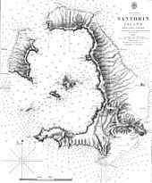
Nea Kameni ( Greek Νέα Καμένη ( f. Sg. ) 'New burned') is an uninhabited Greek volcanic island in the southern Aegean , which administratively belongs to the municipality of Thira within the South Aegean region ( Περιφέρεια Νότιου Αιγαίου ). The island is located in the caldera of Santorini , about 1430 meters west of the main island Thira. Approximately 280 meters southwest of Nea Kameni is the older neighboring island of Palea Kameni .
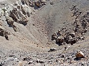
Nea Kameni is almost round and has a diameter of about 2 kilometers with an area of 3,338 km². The almost vegetationless island is approached by numerous tourist boats every day during the season. The visitors climb the 127 meters high volcanic crater , from which sulphurous smoke constantly rises, transforming the surroundings into a “yellow desert”.
History of origin
After the collapse of the Thera volcano as a result of the Minoan eruption in the second half of the 17th century BC. The caldera between Thira, Thirasia and Aspronisi was filled with sea water. It was not until 197 BC. During the reign of Philip V of Macedonia , the first overseas activity of the volcano following the great eruption is known (according to Phyllis Young Forsyth 198/97, according to Emanuela Guidoboni et al. 199/98 BC). The island Hiera or Iera ( Ἱέϱα 'the saint'), also called Automate ( Αὐτομάτη , 'the one that came into being') was created, which Strabo reported had a circumference of 12 stages (approx. 2.2 km). The Rhodians built a temple of Poseidon Asphalios on it . Hiera was roughly at the level of the northeast corner of today's island of Nea Kameni, but sank again and for a long time formed a rocky reef (modern Greek name Ύφαλος Μπάγκος Ifalos Bankos ).
In the years 46 and 47 AD, the volcano became active again and formed the island Theia or Thia ( Θεία 'the divine'), today the main part of Palea Kameni ( Παλαιά Καμένη 'old burned'). The 726 eruption expanded the island to include the lava flow from Agios Nikolaos ( Άγιος Νικόλαος ) in the north. From 1570 to 1573 the island of Mikri Kameni ( Μικρή ήαμένη 'little burned'), which is now part of Nea Kameni, was created. This oldest part of Nea Kameni is located in the north of the island, on the southern edge of the Erinia Bay ( Ερινιά ), where the excursion boats call at the volcanic island. 1707 to 1711 are the actual years of Nea Kameni's birth. Immediately southwest of Mikri Kameni, a volcanic island was formed, about the size of Palea Kameni, which today makes up the northwest part of Nea Kameni. However, there was no land connection with Mikri Kameni. The eruption occurred above the Vulkano Bay ( Όρμος Βουλκάνου ) and poured to the northwest and west.
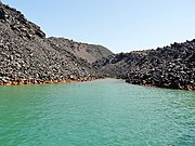
From 1866 to 1870 an eruption from Vulkano Bay expanded the island of Nea Kameni considerably to the southeast and southwest through the lava flows Georgios ( Λάβες Γεώργιου ) and Afroessa ( Λάβες Αφρόεσσας ). At the same time, the Agios Georgios Bay ( Όρμος Αγίου Γεωργίου ) in the west and the two May Islands ( Νησίδες Μάη ) in the southwest, which were later flooded again. The eruption from 1925 to 1928 from the Dafni crater ( Κρατήρες Δάφνης ) established the connection between Nea Kameni and Mikri Kameni. The Dafni lava flow ( Λάβες Δάφνης ) spreading to the north and northeast surrounded the smaller neighboring island and formed with it the Erinia Bay in the north of the now only Nea Kameni volcanic island.
The last major volcanic eruptions of Nea Kameni date back to the middle of the 20th century. From 1939 to 1941, the lava flows Niki ( Νίκη ) to the east, Fouqué ( Φουκέ ) to the north and Ktenas ( Κτενάς ), Reck ( Ρεκ ) and Smith ( Σμιθ ) to the west and southwest, filling the Agios Georgios Bay . In August 1940, two phreatic eruptions formed the central twin crater with its fumaroles on the east side below the 127 meter high summit of Georgios Cathedral, which was built in 1866 . To the east of it is the Niki Cathedral, built in 1941 . A minor eruption in 1950 led to the formation of the Liatsikas Cathedral ( Λάβες Λιάτσικα ) on the southeast side of the summit. Since then, the volcano has been inactive, apart from the 75 to 95 ° C hot gases emerging in the upper twin crater , which consist of water vapors , carbon dioxide and, in extremely small quantities, hydrogen sulfide , carbon monoxide and methane .
literature
- Walter L. Friedrich: Fire in the sea. The Santorini volcano, its natural history and the legend of Atlantis. 2nd edition, Spektrum Akademischer Verlag, Munich 2005, pp. 12f, 182–199. ISBN 3-8274-1582-9
Individual evidence
- ^ Charles Arnold (ed.): The islands of the Mediterranean . A unique and complete overview. 2nd Edition. marebuchverlag, Hamburg 2008, ISBN 978-3-86648-096-4 , p. 343 .
- ↑ Volcanological map of Palea and Nea Kameni (Institute for Study and Observation of the Santorini volcano), Ηφαιστειολογικός χάρτης Παλαιάς και Νέας Καμένης (Ινστιτούτου Μελέτης και Παρακολούθησης του Ηφαιστείου Σαντορίνης ΙΜΠΗΣ ): Hfaisteiologikos_xartis_Paleas_kai_Neas_Kamenis.pdf ( Memento of 7 January 2014 Internet Archive ) , Greek (PDF, 393 kB)
- ↑ After Gerhard Waldherr : Earthquake - The Extraordinary Normal. On the reception of seismic activities in literary sources from the 4th century BC Until the 4th century AD (= Geographica historica Bd. 9) Franz Steiner, Stuttgart 1997, ISBN 3-515-07070-2 , p. 230 note 66.
- ↑ Pliny , Naturalis historia 2, 89 ( translation by Philipp Hedwig Külb 1840)
- ^ Eugen Oberhummer : Automate . In: Paulys Realencyclopadie der classischen Antiquity Science (RE). Volume II, 2, Stuttgart 1896, Col. 2604. Ludwig Bürchner : Hiera . In: Paulys Realencyclopadie der classischen Antiquity Science (RE). Volume VIII, 2, Stuttgart 1913, Sp. 1396.
- ^ Strabon , Geographica 1, 3, 16 ( translation by Albert Forbiger 1856).
- ↑ The Formation of the Kameni Islands. Geothira MAE information sheet; see also Hfaisteiologikos_xartis_Paleas_kai_Neas_Kamenis.pdf ( Memento from January 7, 2014 in the Internet Archive ), Greek, PDF, 393 kB
Web links
- Institute for the Study and Monitoring of the Santorini Volcano (ISMOSAV)
- Santorin in the Global Volcanism Program of the Smithsonian Institution (English)


