Nellis Range
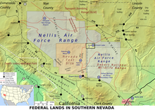
The Nellis Range (also Nellis Range Complex (NRC) , Nellis Air Force Range (NAFR) ) is a restricted military area in southern Nevada between Las Vegas and Tonopah with a size of more than 31,000 square kilometers. It is connected to the Nellis AFB and the scene of the “ Red Flag ” maneuvers that take place several times a year . The restricted area was named after William Harrell Nellis .
It is the location of several military installations known beyond the state and national borders:
- Nevada Test Site in the southwest, site of countless above and below ground nuclear tests
- Tonopah Test Range and the Tonopah Test Range Airport in the northwest, home base of the 4450th Tactical Fighter Group with their F-117A Stealth Fighters during confidentiality time
- Area 51 or Groom Lake Air Force Base , one of the most secret places in the western world and therefore the origin of numerous myths such as stories of secret planes, UFOs and extraterrestrial life forms.
There are different levels of access within the Nellis Range. The eastern part is only restricted to civil air traffic . The western part, which houses all of the above-mentioned installations and begins roughly west of US Highway 93 and Highway 375 and almost reaches US Highway 95 Reno-Las Vegas in the west , is a restricted military area. The area around Groom Lake (also known as Area 51 ) is even closed to registered military flights, especially for participants in the Red Flag maneuver.
Web links
- Nevada airspace map (PDF file; 2.7 MB)
- Nevada Test and Training Range
Individual evidence
Coordinates: 37 ° 30 ′ 0 ″ N , 116 ° 37 ′ 0 ″ W.
