Nemda (Pischma)
|
Nemda Не́мда, Немде, Лемде |
||
| Data | ||
| Water code | RU : 10010300412111100037273 | |
| location | Mari El , Kirov Oblast ( Russia ) | |
| River system | Volga | |
| Drain over | Pishma → Vyatka → Kama → Volga → Caspian Sea | |
| source | southeast of Kuschener 56 ° 45 ′ 56 ″ N , 48 ° 57 ′ 13 ″ E |
|
| Source height | 194 m | |
| muzzle | near Sowetsk in the Pischma coordinates: 57 ° 35 ′ 5 ″ N , 48 ° 55 ′ 12 ″ E 57 ° 35 ′ 5 ″ N , 48 ° 55 ′ 12 ″ E |
|
| Mouth height | 78 m | |
| Height difference | 116 m | |
| Bottom slope | 0.72 ‰ | |
| length | 162 km | |
| Catchment area | 3780 km² | |
| Outflow location: 22 km above the mouth |
MQ |
6 m³ / s |
| Left tributaries | Tolman | |
| Right tributaries | Lax | |
| Small towns | Sovetsk | |
| Communities | Kuschener | |
|
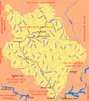
Course of the Nemda (Не́мда) in the catchment area of the Vjatka |
||
The Nemda ( Russian: Не́мда ; Mari Немде, Лемде ) is a right tributary of the Pishma in the Republic of Mari El and in Kirov Oblast .
The Nemda rises southeast of the village of Kuschener in the Republic of Mari El. It flows in a predominantly northerly direction into the Kirov Oblast and finally flows into the Pishma flowing east at Sovetsk , 9 km above its mouth in the Vyatka . It runs on the edge of the Vyatsky Uwal ridge .
The Nemda has a length of 162 km. It drains an area of 3780 km². It is mainly fed by the snowmelt . 22 km above the mouth, the mean discharge is 6 m³ / s. The river is usually ice-covered between mid-November and mid-April. At least in the past, rafting was carried out on the Nemda .

