Pishma (Vyatka)
|
Pischma Пи́жма |
||
| Data | ||
| Water code | RU : 10010300412111100036375 | |
| location | Nizhny Novgorod , Kirov Oblast ( Russia ) | |
| River system | Volga | |
| Drain over | Vyatka → Kama → Volga → Caspian Sea | |
| source | southeast of Shakhunya 57 ° 36 ′ 35 ″ N , 46 ° 53 ′ 22 ″ E |
|
| Source height | approx. 160 m | |
| muzzle |
Vyatka near Sowetsk Coordinates: 57 ° 36 '52 " N , 49 ° 3' 6" E 57 ° 36 '52 " N , 49 ° 3' 6" E |
|
| Mouth height | 77 m | |
| Height difference | approx. 83 m | |
| Bottom slope | approx. 0.27 ‰ | |
| length | 305 km | |
| Catchment area | 14,660 km² | |
| Drain |
MQ |
90 m³ / s |
| Left tributaries | Juma | |
| Right tributaries | Oschma, Jaran , Isch, Nemda | |
| Small towns | Tonschajewo , Sovetsk | |
| Navigable | 132 km (from Tuscha) | |
|
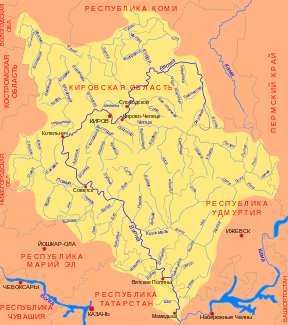
Course of the Pischma (Пи́жма) in the catchment area of the Vyatka |
||
The Pischma ( Russian Пи́жма ) is a 305 kilometers long right tributary of the Vyatka north of the Volga region in the European part of Russia .
course
The Pischma rises in the extreme northeast of the Nizhny Novgorod Oblast , almost 20 km southeast of the city of Shakhunya at an altitude of about 160 m . It flows first to the north, then to the east, before turning in a southeastern direction when it reaches Kirov Oblast . It marks the oblast border for about 30 km. For the last 100 km or so, the Pischma flows in an easterly direction. It meanders strongly throughout the course . Immediately below the small town of Sovetsk , the river flows into two arms, which form the river island Bobylski, at a height of 77 m in the Vyatka.
The most important tributaries of the Pischma are Oschma, Jaran , Isch (not to be confused with the tributary of the same name of the Kama ) and Nemda from the right and Juma from the left.
Hydrography
The catchment area of the Pischma covers 14,660 km². Above the estuary, the river reaches a width of over 200 meters after having taken up the important tributary Nemda only 2.5 km earlier; the flow velocity here is 0.2 m / s.
The Pischma freezes between mid-November and the second half of April. The water flow is an annual average of 90 m³ / s.
Infrastructure and economy
The Pischma is navigable for 132 km from a road bridge not far from the urban-type Tuscha settlement . Here the Vyatka trunk road crosses the river from Cheboksary on the Volga via the Kirov Oblast Administrative Center to Syktyvkar , the capital of the Komi Republic .
The only larger towns directly on the river are the urban-type settlement of Tonschajewo on the upper reaches and the town of Sovetsk on the lower reaches. Only a few kilometers away, however, are the urban settlements or Rajon administrative centers of Pischma , Tuscha and Arbasch . The upper reaches of the Pizhma River is twice by the railway line Moscow - Nizhny Novgorod - Kotelnich crosses, for some years the main route of the Trans-Siberian Railway passenger. In the mouth near the regional road, the right Wjatkaufer down crosses Urzhum and malmyzh according vyatskiye polyany results in the river.
In the sparsely populated and densely forested area on the upper reaches of the river, on the territory of the Nizhny Novgorod Oblast, forestry plays a major role. The proportion of agricultural areas increases downstream.
Web links
Individual evidence
- ↑ a b c Article Pischma in the Great Soviet Encyclopedia (BSE) , 3rd edition 1969–1978 (Russian)
- ↑ Pischma in the State Water Register of the Russian Federation (Russian)
- ^ List of Inland Waterways of the Russian Federation (confirmed by Order No. 1800 of the Government of the Russian Federation of December 19, 2002); on-line

