
Neschwilerbach
|
Neschwilerbach Schliifibach (upper course), Wiestobelbach, Wildbach |
||
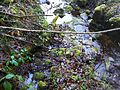
 The Neschwilerbach in its ravine near Stutz |
||
| Data | ||
| Water code | CH : 101377 | |
| location | Switzerland | |
| River system | Rhine | |
| Drain over | Tobelbach → Töss → Rhine → North Sea | |
| source | southeast of the Pfäffiker hamlet of Schür 47 ° 25 ′ 35 ″ N , 8 ° 47 ′ 10 ″ E |
|
| Source height | approx. 664 m above sea level M. | |
| muzzle | near Hinterrikon in the Tobelbach Coordinates: 47 ° 26 '14 " N , 8 ° 47' 49" E ; CH1903: 702 468 / 254949 47 ° 26 '14 " N , 8 ° 47' 49" O |
|
| Mouth height | approx. 520 m above sea level M. | |
| Height difference | approx. 144 m | |
| Bottom slope | approx. 85 ‰ | |
| length | 1.7 km | |
| Left tributaries | Aespenbächli, Stutzbach | |
| Communities | Weisslingen , Zell | |
 Mouth of the Neschwilerbach |
||
The Neschwilerbach (in the upper reaches of Schliifibach) is a 1.7 kilometer long tributary to the left of the Tobelbach in the Swiss canton of Zurich . The brook drains a section of the Tösstal region in the Zurich Oberland .
geography
course

The stream rises at about 664 m above sea level. M. as Schliifibach little southwest of the Weisslinger outer guard Neschwil . The gutted spring is located on Eggbüülweg on the northern border of the Egg forest area . At first it flows under the fields of the Awändel area, always overturned , and then under Neschwil, where it is mostly directed to the north-northeast. At the Underdorf it comes to the surface for the first time and at the same time flows through a steep and densely wooded ravine to the northeast. After the confluence of the Aespenbächlis from the left, the stream passes two waterfalls, the larger of which is eight meters high. Immediately thereafter, it briefly forms the municipality boundary with Zell before it completely crosses the border.
The stream is now referred to as the Neschwilerbach. At the same time, the Stutzbach pours out from the left , and the stream reaches the Tobel , the here relatively wide valley of the Tobelbach. It crosses - now accompanied by sparse trees - the Schochenwis on the right bank and the Schürwiesen on the left bank. The stream finally flows under the Tobelstrasse at about 520 m above sea level. M. between Tobelhof in the southeast and Hinterrikon in the north in the lower reaches of the Tobelbach, whose last major tributary it represents.
Tributaries
The direct and indirect tributaries downstream
- Aespenbächli ( left ), 0.7 km
- Stutzbach ( left ), 0.4 km
- Erlenweidbächli ( right ), 0.3 km
photos

Neschwilerbach before the confluence of the Stutzbach

Neschwilerbach before the confluence of the Stutzbach
The mouth of the Stutzbach (from left) into the Neschwilerbach


Web links
- Course of the Neschwilerbach on GIS Zurich
- Course of the Neschwilerbach on the geoserver of the Swiss federal administration
Individual evidence
- ^ State Archives of the Canton of Zurich
- ↑ a b Geographic Information System of the Canton of Zurich
- ↑ Geoserver of the Swiss Federal Administration ( information )
- ↑ Lengths rounded to one decimal place