Nettelgraben
| Nettelgraben | |
|---|---|
|
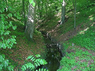
Nettelgraben at the Chorin monastery (cut through to the Ragöse, probably from the 15th century) |
|
| location | Germany: Brandenburg |
| length | Almost 5 kilometers |
| Built | 13th Century |
| Beginning | Parsteiner See |
| The End | Amtssee , Ragöse |
| Drainage of the Parsteiner See to the Oder ; laid out by the Cistercian monks of the Chorin monastery | |
The Nettelgraben is an artificial waterway in the Brandenburg district of Barnim and is located in the Schorfheide-Chorin biosphere reserve . The nearly five-kilometer-long ditch forms the only outflow of the Parsteiner See and connects it to the Ragöse (Ragöser Fließ) via the Weißen See and the Choriner Amtssee .
The moat passes through the relief rich countryside west of Endmoränenbogens Chorin with glaciofluvial sands and gravel of Sander from the Angermünder season of Weichseleis -Rückzugs.
The moat was dug in the 13th century by the monks of the Cistercian monastery in Chorin , as the ragose runoff from the Choriner See (now the Amtssee) did not supply enough water to operate the monastery mills and to supply the monastery, which is located directly on the lake. The monastery brothers achieved the necessary water supply with the construction of the Nettelgraben from the Choriner See to the higher and now isolated White See, which formed a bay of the Parsteiner See when it was built in the 13th century.
- → Section Construction of the Nettelgraben lake drainage in the Parsteiner See article
The trench had a significant impact on the hydrogeology and amelioration of the region around Chorin. For example, it drains the Plagefenn , a total reserve that is specially protected as a natural reserve , through the Gottesgraben flowing towards the White Lake , whose wetlands and lakes have partially silted up. The waters flowed to the Oder via the Ragöse, Finow Canal and Oder-Havel Canal . The Plagefenn and the Parsteiner See were inland drainage areas until the trench was built.
Today the water supply in the Nettelgraben is largely regulated by extensive measures to protect the biotopes . It is accepted that the trench will temporarily dry out. For example, when measurements were taken in 1996, the Nettelgraben had no water.
Individual evidence
- ^ Fritz Brose: Ice retreat in the Parstein Basin. In: Guide to the geology of Berlin and Brandenburg, ... , pp. 95-103
- ↑ Management plan for the Plagefenn area ( Memento of the original from October 3, 2017 in the Internet Archive ) Info: The archive link was automatically inserted and not yet checked. Please check the original and archive link according to the instructions and then remove this notice. Ministry of Rural Development, Environment and Agriculture (MLUL); Country Brandenburg; Potsdam; September 2015; On: icoworks-online.de; (PDF; German; 5.14 MB)
- ↑ Brigitte Nixdorf, Mike Hemm u. a .: Documentation ...
literature
- Wolfgang Erdmann: Cistercian Abbey Chorin. History, architecture, cult and piety, prince claims and self-portrayal, monastic economics and interactions with the medieval environment. With the collaboration of Gisela Gooß, Manfred Krause and Gunther Nisch. Verlag Karl Robert Langewiesche Successor Hans Köster Verlagsbuchhandlung KG , Königstein i. Ts. 1994 (series: The Blue Books). ISBN 3-7845-0352-7 , see pages 10f, 48f
- Guide to the Geology of Berlin and Brandenburg, No. 2, Bad Freienwalde - Parsteiner See , Johannes H. Schroeder (Ed.), Geoscientist in Berlin and Brandenburg eV, Self-published Berlin, 2nd improved edition 1994, ISBN 3-928651-03- X , ISSN 0941-2980
- Rüdiger Michels: Hydrological rehabilitation in the Plagefenn . In: 100 years of the Plagefenn nature reserve . Eberswalder Forstliche Schriftenreihe Volume XXXI. Ed .: MLUV des Landes Brandenburg Landesforstanstalt Eberswalde, conference proceedings for the anniversary event from May 11 to 12, 2007 in Chorin, Eberswalde 2007, pp. 41–46 pdf
- Brigitte Nixdorf, Mike Hemm u. a .: Documentation of the condition and development of the most important lakes in Germany, part 5, Brandenburg , environmental research plan of the Federal Ministry for the Environment, Nature Conservation and Nuclear Safety , final report R&D project FKZ 299 24 274, on behalf of the Federal Environment Agency at the Chair of Water Protection at the Brandenburg Technical University Cottbus , 2004 Chapter 1.22 Parsteiner See pp. 92–96, pdf
Coordinates: 52 ° 54 ′ 33 ″ N , 13 ° 55 ′ 5 ″ E
