Neuhauser See
| Neuhauser See | ||
|---|---|---|

|
||
| Geographical location | Northern Saxony district | |
| Tributaries | Groundwater / precipitation | |
| Drain | trough | |
| Places on the shore | Benndorf | |
| Location close to the shore | Delitzsch | |
| Data | ||
| Coordinates | 51 ° 34 '3 " N , 12 ° 19' 35" E | |
|
|
||
| Altitude above sea level | 78 m above sea level NHN | |
| surface | 1.55 km² | |
| length | 3.6 km | |
| width | 1.1 km | |
| volume | 18 km³ (1.8 × 10 10 m³ ) | |
| Maximum depth | 27.1 m | |
| Middle deep | 15 m | |
|
particularities |
||
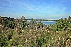
The Neuhäuser See (also Neuhauser See ) is an approximately 155 hectare open-cast mine that was created by flooding from the former Holzweißig-West opencast mine . The lake is located in the Saxon Lake District , south of the Goitzsche nature reserve and north of the city of Delitzsch .
location
The Neuhäuser See is located on the north-western border of the Free State of Saxony to Saxony-Anhalt , at an altitude of about 78 m above sea level. NN . To the south of the lake is Benndorf , part of the northern Saxon district town of Delitzsch and to the north is the Saxon-Anhalt community of Bitterfeld-Wolfen . It is located in the Saxon Lake District, south of the Great Goitzschesees and the waters of Ludwigsee and Paupitzscher See .
history
In the middle of the 19th century the first mining activities began in the southwest of the Goitzsche, near the towns of Petersroda and Holzweißig . Following the lignite seam, mining moved from west to east. Benefiting from the opening of today's Magdeburg – Leipzig and Trebnitz – Leipzig railway lines, the sales market for lignite expanded to, among other places, Halle and Leipzig . The increased demand for electrical energy and fossil fuels in the 19th and 20th centuries led to the opening of the Leopold opencast mine in 1908 (from 1945 to 1962 Holzweißig-Ost ) and in 1958 to the emergence of the Holzweißig-West opencast mine .
The Neuhäuser See emerged from the former open- cast lignite mine Holzweißig-West . It is named after Gut Neuhaus, which was demolished in 1976 with the town of Paupitzsch . The Holzweißig-West opencast mine was operated from 1958 to 1980. Other sources report that it was used until 1991. The lake was flooded from 1993 to 2005. Overflowing water is channeled into the hollow via the Goitzsche . Since 1997 the site has been renatured and stable embankments created.
use
Today, a well-developed network of cycling and hiking trails with viewing platforms and information boards on the formation of the landscape extends along the Neuhäuser See. The 120 km long coal-steam-light cycle path from Lutherstadt Wittenberg to Markkleeberg leads past the lake.
See also
Web links
- LMBV
- New Lakeland for Investors: Data on Neuhäuser See (PDF; 841 kB)
- History of the Goitzsche opencast mine
Individual evidence
- ↑ a b c Lausitzer und Mitteldeutsche Bergbau-Verwaltungsgesellschaft mbH: data on the lakes in the Bitterfeld area
- ↑ a b Investors New Lakeland: data on Neuhäuser See ( page no longer available , search in web archives ) Info: The link was automatically marked as defective. Please check the link according to the instructions and then remove this notice. (PDF; 841 kB)
- ↑ a b History of the Goitzsche , accessed on April 6, 2013.
