
Neumarkt in the diving valley
|
Neumarkt im Tauchental ( village ) locality cadastral community Neumarkt im Tauchental |
|||
|---|---|---|---|
|
|||
| Basic data | |||
| Pole. District , state | Oberwart (OW), Burgenland | ||
| Judicial district | Oberwart | ||
| Pole. local community | Stadtschlaining | ||
| Coordinates | 47 ° 17 '51 " N , 16 ° 17' 57" E | ||
| height | 321 m above sea level A. | ||
| Residents of the village | 395 (January 1, 2020) | ||
| Building status | 180 (2001) | ||
| Area d. KG | 11.18 km² | ||
| Statistical identification | |||
| Locality code | 00305 | ||
| Cadastral parish number | 34051 | ||
| Counting district / district | Neumarkt im Tauchental (10923 002) | ||
| Source: STAT : index of places ; BEV : GEONAM ; GIS-Bgld | |||

The place Neumarkt im Tauchental is a district of Stadtschlaining .
Neumarkt im Tauchental is a narrow village south of Stadtschlaining. From the Catholic parish church of St. Nikolaus extends a hill to the west. In the south of the Angers are a number of Streckhöfe with hip gables. In Scheidestrasse is a group of Streckhöfe and Hakenhöfe.
The first chronistic mention was in 1289 with the name Niclastuern , the first written mention in 1325 with Kedhel . The place is an old German settlement. Croatians also settled here in the 16th century.
Culture and sights
- Catholic parish church Neumarkt im Tauchental
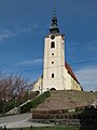
Parish church Neumarkt im Tauchental

High altar of the parish church
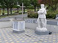
War memorial
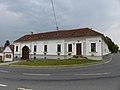
Former inn (listed)


Web links
literature
- Dehio manual. The art monuments of Austria: Burgenland. Neumarkt in the diving valley. Bundesdenkmalamt (Ed.), Verlag Anton Schroll & Co, Vienna 1976, ISBN 3-7031-0401-5 , page 207.

Cadastral communities: Altschlaining | Drumling | Goberling | Neumarkt im Tauchental | Stadtschlaining
Locations: Altschlaining | Drumling | Goberling | Neumarkt im Tauchental | Stadtschlaining
City: Stadtschlaining Villages: Altschlaining • Drumling • Goberling • Neumarkt im Tauchental Rotte: Schönau Scattered houses: Dornau • Gieberling ( Karlshof ) Other locations: Burg Schlaining
Counting district: Stadtschlaining | Altschlaining | Neumarkt im Tauchental | Drumling | Goberling