Obstmarschenweg
The Obstmarschenweg leads for almost 100 km through the southern Elbmarschen in Kehdingen, past Stade and through the Alte Land to Hamburg . It runs through one of the largest fruit-growing areas in the world and is particularly worth seeing in spring, for example during the cherry blossom season.
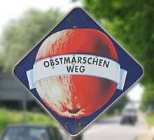
There are many traditional fruit farms on the sides, which mainly offer apples and cherries in the farm shop, but often all sorts of other fruit and vegetables. The well-tended half-timbered houses, often several centuries old, allow a glimpse into the past of the Elbmarschen, and in some places there is an educational fruit trail. As a tourist recommendation, the Obstmarschenweg is therefore also featured in the area's travel guides and local cycling maps. At irregular intervals it is marked with a square sign on the tip that shows an apple.
The Obstmarschenweg connects numerous villages that have emerged along the marshland in the glacial valley of the Elbe . It starts (presumably) in Balje and leads over
- Freiburg / Elbe ,
- Drochtersen ,
- Bützfleth ,
- Hollern ,
- Grünendeich ,
- Steinkirchen ,
- Mittelkirchen ,
- Jork
- Neuenfelde
Direction Hamburg .
It is unclear whether the Obstmarschenweg was once the main road along the Elbe, or whether various streets were artificially merged into the Obstmarschenweg afterwards. However, since the main street in many of the towns has actually been called Obstmarschenweg for a long time, the first variant seems more likely. In other places the official street name is partly different (for example Huttfleth in Grünendeich ).
The name Obstmarschenweg was determined in 1956 through a competition by the advertising committee for the Lower Elbian fruit-growing region. There were 309 letters with 423 suggested names. The first winner of 100 DM was Emil Volkmer from Basbeck Land Hadeln. 150 signposts in the shape of an apple and the name were placed along the road. According to the wishes of the fruit growers, the name "Obstmarschenweg" should be the counterpart to the Bergstrasse in the Odenwald.
