Lake Okeechobee
| Lake Okeechobee | ||
|---|---|---|

|
||
| View over the lake | ||
| Geographical location | southern Florida | |
| Tributaries | Provo , Taylor Creek, Kissimmee River | |
| Drain | Everglades | |
| Islands | Kreamer, Torry, Ritta, Grass, Observation, Bird, Horse, Hog, Eagle Bay | |
| Places on the shore | Belle Glade , Pahokee | |
| Data | ||
| Coordinates | 26 ° 56 ′ N , 80 ° 48 ′ W | |
|
|
||
| Altitude above sea level | 3.74 to 5.49 m | |
| surface | 1,890 km² | |
| length | 58 km | |
| width | 47 km | |
| volume | 5.2 km³ | |
| scope | 197 km | |
| Maximum depth | 3.7 m | |
| Middle deep | 2.7 m | |

|
||
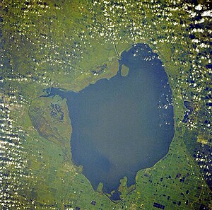
| Satellite image | ||
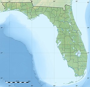
The Okeechobee Lake ( English Lake Okeechobee , [ ˌoʊkɨˈtʃoʊbiː ], locally also known as The Lake or The Big O ) is the largest lake in the US state of Florida with a water surface of about 1890 square kilometers . The - after Lake Michigan and Iliamna Lake (Alaska) - the third largest freshwater lake located entirely in the United States is located in the southern part of Florida between the cities of Orlando and Miami . The lake is divided between Counties of Glades , Okeechobee , Martin , Palm Beach and Hendry , all five of which meet at a point near the center of the lake.
colonization
The area around the lake was settled relatively late. Since approx. 1000 BC Chr. Developed there in the wetlands, the Belle Glade culture, fishing culture, a series of archaeological evidence has left so especially characteristic mounds ( mounds ), which served as flood protection, clam shell heap in large quantities, shark teeth and pottery. In the 16th century, the Spaniards met the Mayaimi at the lake, who should not be confused with Miami , which is neither ethnically nor linguistically related . It is uncertain whether the Mayaimi were the bearers of the Belle Glade culture, which perished around 1700. At the beginning of the 18th century, the Mayaca , who originally lived on the upper reaches of the St. Johns River , settled at the lake. There they were subjugated by the Calusa and wiped out as a people until around 1750.
Name and origin of name
The name Okeechobee comes from the now extinct Hitchiti, which is part of the Hitchiti-Mikasuki language . The Hitchiti simply called the lake "Big Water" (from oki 'water' and chubi 'big') because of its enormous size . The oldest known name, however, is Lake Mayaimi ( Mayaimi also means "great water"), which was handed down by the Spaniard Hernando de Escalante Fontaneda in the 16th century. The Mayaimi Indians who settled there were named after the lake. A short time later in the 16th century, René Goulaine de Laudonnière reported that he had heard of a large freshwater lake in southern Florida called Serrope . In the 18th century, the then largely mythical lake was known by British cartographers and chroniclers under the Spanish name Laguna de Espiritu Santo ("Lake of the Holy Spirit"). In the early 19th century, the lake was known as Mayacco Lake or Lake Mayaca , named after the Mayaca Indian tribe. The modern Port Mayaca in Martin County on the east bank of the lake keeps the name to this day. In addition, the lake was also called Lake Macaco in the early 19th century .
Location and geology
It is around 56 km long, up to 48 km wide and covers a water surface of around 1890 km². With an average depth of 3 meters, it is very shallow. The lack of a major natural runoff caused numerous floods in the past, which resulted in the wet and marshy areas of the Everglades in the southwest of the lake .
The Okeechobee lies in a wide salty limestone basin and reaches a depth of up to four meters. It was only created about 6000 years ago. It is surrounded by a dike up to six meters high , which was built by the US Army Corps of Engineers . It is the consequence of a flood disaster in 1928 , when a hurricane blew the water over the old dike and killed around 2,400 people. Two years earlier, 800 people had died in a similar accident.
Environmental situation
The lake plays a major role in the water balance of the Everglades National Park . A lot of water was withdrawn from the lake due to the cities' high demand for drinking water and the cultivation of sugar cane. It was also extremely contaminated with phosphates , salts and organic residues from other branches of the surrounding intensive agriculture - cultivation of citrus fruits and cattle breeding . Due to the abundance of nutrients, blue-green algae and coli bacteria multiplied and fish died. Over 33,000 tons of phosphorus are said to have deposited on the lake floor. The lake has only a few minor outflows, which include the Miami River , Shark River, and New River . When it rains, the salts are only partially rinsed out again through these. In 2008 the farms were bought by the state of Florida to shut them down and end the water shortages in the lake and the Everglades.
Hurricanes
In 1926, the area was hit by the Great Miami Hurricane . About 300 people lost their lives. Two years later, in 1928, Hurricane Okeechobee devastated the area around the lake. The Red Cross named the number of 1836 dead. That estimate was raised to at least 2500 by the National Weather Service in 2003. In both cases, the strong winds triggered a storm surge that was not held back by the dam, which was two meters high at the time.
After these two hurricanes, Florida lawmakers created the Okeechobee Flood Control District . This agency was tasked with working with the US Army Corps of Engineers to prevent similar disasters. After a visit from President Herbert Hoover , Army engineers drew up a plan that included several canals, locks and dams. As part of this work, the Okeechobee Waterway was created , an artificial waterway from Fort Myers on the west coast of Florida to Port Stuart on the east coast, which crosses the lake.
Fishing industry
Economically relevant fish in the lake are the largemouth bass , the crappie and the bluegill (blue gill). Pike are caught less frequently.
literature
- Hann, John H. (1993). "The Mayaca and Jororo and Missions to Them", in McEwan, Bonnie G. (ed.) The Spanish Missions of La Florida. University Press of Florida. ISBN 0-8130-1232-5 .
- Hann, John H. (2003). Indians of Central and South Florida: 1513-1763 . University Press of Florida. ISBN 0-8130-2645-8
Web links
Individual evidence
- ^ Mosquito County, Florida, 1830 (map) . University of South Florida. Retrieved April 24, 2011.
- ^ Protecting our water. Florida Department of Environmental Protection , accessed May 22, 2020 .
