
Okeechobee Hurricane (1928)
| Category 5 hurricane ( SSHWS ) | ||
|---|---|---|
 |
||
| Emergence | September 6, 1928 | |
| resolution | September 20, 1928 | |
|
Peak wind speed |
|
|
| Lowest air pressure | 929 mbar ( hPa ; 27.4 inHg ) | |
| dead | 4079+ | |
| Property damage | $ 100 million (1928) | |
|
Affected areas |
Lesser Antilles , Guadeloupe , US Virgin Islands , Puerto Rico , Bahamas , Florida , Georgia , South Carolina , North Carolina , East Coast | |
| Season overview: 1928 Atlantic hurricane season |
||
The Okeechobee hurricane, or Huracán San Felipe Segundo, was the most momentous tropical cyclone of the 1928 Atlantic hurricane season . He moved through Guadeloupe , the Leeward Islands , Puerto Rico , the Bahamas and Florida in September of that year . The hurricane formed off the west coast of Africa on September 6 and intensified during the day to a tropical storm just before it passed south of Cape Verde. In the days that followed, the storm moved westward across the tropical Atlantic, developing little at first, but then quickly. He reached Guadeloupe on September 12th. The hurricane devastated the islands, killing 1200 people. The islands of Martinique , Montserrat and Nevis also reported property damage and personal damage, but this was nowhere near the level of damage in Guadeloupe.
At noon on September 13, the hurricane was the first to reach category 5 of the Saffir-Simpson hurricane scale introduced a few decades later with measured sustained wind speeds above 200 km / h . To date, this is the only time since reliable observations began that a hurricane of this strength has struck Puerto Rico. The impact of the hurricane killed 312 people on the island. Strong winds destroyed 24,728 homes and damaged 142,444 others; more than half a million islanders became homeless. Heavy rain damaged vegetation and agriculture. The economic damage on the island has been estimated at 50 million US dollars (700 million US dollars in today's prices). When crossing the island, the hurricane lost its force and therefore reached the Bahamas as a Category 4 hurricane, where, thanks to good preparations for the storm, only 18 people lost their lives due to the effects of the storm.
Early on September 17th, the hurricane hit West Palm Beach over the mainland of Florida with winds of 238 km / h. 1,711 homes in the city were destroyed, but Florida was hit hardest in the Lake Okeechobee area . The wind-generated storm surge sloshed over the southern edge of the lake and inundated hundreds of square kilometers of land up to six meters high, including Belle Glade , Canal Point , Chosen, Pahokee and South Bay . At least 2,500 Florida residents were killed by the effects of the storm. Over the mainland of Florida, the hurricane weakened to Category 1 and took a northeast orbit. A day later, the hurricane came once more over the open ocean and finally over land at Edisto Island , South Carolina , with wind speeds of 140 km / h. In the early part of September 19th, the system over North Carolina broke up. In total, the storm caused more than $ 100 million in property damage ($ 1,500 million in today's prices) and killed at least 4,079 people. At least 2,500 people died when the dike at Lake Okeecho in southern Florida broke.
Storm course

On September 6, ships reported a tropical low pressure area forming directly off the west coast of Africa near Dakar , Senegal . The next day a ship reported wind speeds of 95 km / h - this corresponds to wind force 10 on the Beaufort scale - and based on this information, the hurricane analysis assumed that the system had reached the status of a tropical storm late on September 6th. However, because the storm moved far away from land and shipping for several days, the lack of observation values meant that the system was not classified as a tropical storm or hurricane on its way west across the tropical Atlantic Ocean. The storm was first observed as such on September 10 by the SS Commack , approximately 1,450 km east of Guadeloupe . This was the easternmost tropical cyclone reported by ship radio up to that point. During the course of the day, two other ships confirmed the reported intensity, and the Hurricane Research Division of the National Hurricane Center therefore assumes that the storm intensified into a hurricane on September 10 at 6:00 p.m. UTC.
The hurricane intensified as it approached the Lesser Antilles . His eye crossed Guadeloupe on September 12 between 5:30 and 6:30 p.m. UTC , where an air pressure of 940 mbar was measured, which indicates sustained wind speeds of 240 km / h, the category 4 equivalent of today's Saffir-Simpson Hurricane scale. The hurricane then moved west-northwest over the Leeward Islands , and the center passed Saint Croix about 15 km south before hurricane approached Puerto Rico. On September 13, the center of the hurricane crossed the island from southeast to northwest within eight hours after moving overland at Guayama and before reaching the sea again between Aguadilla and Isabela . A ship just south of the Puerto Rico coast reported an air pressure of 931 mbar, and an anemometer in San Juan recorded wind speeds of nearly 270 km / h before it failed. Because this station was around 50 km north of the storm center, the wind speeds for the landfall point were unofficially assumed to be up to 320 km / h. Accordingly, the Puerto Rico hurricane landed as a Category 5 hurricane ; however, there are inaccuracies in the peak intensity because of the large extent and the slow movement.
| rank | hurricane | season | Air pressure (in mbar ) |
|---|---|---|---|
| 1 | Labor day | 1935 | 892 |
| 2 | Camille | 1969 | 900 |
| 3 | Irma | 2017 | 914 |
| 4th | Katrina | 2005 | 920 |
| 5 | Andrew | 1992 | 922 |
| 6th | Indianola | 1886 | 925 |
| 7th | Florida Keys | 1919 | 927 |
| 8th | Okeechobee | 1928 | 929 |
| 9 | Miami | 1926 | 930 |
| 10 | donna | 1960 | 932 |
| Source: HURDAT, Hurricane Research Division | |||
After crossing Puerto Rico, the hurricane subsided; the measured air pressure in Isabela of 941 mbar indicated wind speeds of 240 km / h. The system moved west-northwest and grazed the north coast of Hispaniola . Gaining strength again, the hurricane passed Grand Turk on September 15 at a distance of less than 55 km; at this point in time the continuous wind speeds increased to 250 km / h. Accordingly, it moved through the Bahamas as a Category 4 hurricane and was at Nassau on September 16 at 10:00 UTC . Originally, meteorologist Richard Gray of the US Weather Bureau was optimistic that the hurricane would spare southern Florida.
On September 17 at 00:00 UTC, the center of the hurricane crossed the coast in southeast Florida near West Palm Beach with an estimated wind speed of 230 km / h. This assessment results from the air pressure measured in the city of 929 mbar, at the time the lowest air pressure measured in the United States; the previous low of 935 mbar was measured during the Miami hurricane in 1926 . Peak gusts of an estimated 260 km / h occurred at Canal Point .
On the way over the mainland and Lake Okeechobee, the hurricane quickly lost strength, although it was able to maintain its status as a hurricane for several days due to its large extent. Late on September 17, the hurricane swung northeast and passed Jacksonville early the following day with winds of 120 km / h. At 8:00 a.m. UTC on September 18, the storm returned to open water. During the course of the day the hurricane intensified again slightly and finally reached over land at Edisto Island, South Carolina at 19:00 UTC with wind speeds of 140 km / h. The train speed to the northeast accelerated, and the hurricane quickly turned into a tropical storm over North Carolina. On September 19, the tropical storm changed into an extra-tropical system and reached hurricane strength again . The system eventually headed north-northwest and quickly crossed the states on the east coast of the United States . On September 21, the former hurricane over Ontario broke up by merging with another fault.
260 km / h in Puerto Rico was the highest sustained wind speed that had been measured for an Atlantic hurricane up to that point. It wasn't until 1950 that a stronger storm was recorded with Hurricane Dog . Based on this measurement, the Okeechobee hurricane is considered to be the first hurricane in the Atlantic basin to reach category 5. However, it is certain that previous storms have already reached this strength, e. B. 1846 the Great Havana Hurricane , but there were no measured wind speeds before 1886.
Naming
Before 1953, there was no official scheme for assigning names to tropical cyclones in the Atlantic Basin. Since the beginning of Spanish colonization in 1492, it has been a custom to name hurricanes after the Roman Catholic saints of the day they hit Puerto Rico. The hurricane is also known under the name Huracán San Felipe Segundo or San Felipe II Hurricane because the eye of the storm reached Puerto Rico on the Christian holiday of Saint Philip . It was called “Segundo” (Spanish for “the second”) because Puerto Rico was hit by a devastating hurricane, the San Felipe Hurricane , 52 years earlier on the same day in 1876 . In 1953 the United States began naming hurricanes with female first names - from 1978 onwards, first names of both sexes were used on an annual basis - but in Puerto Rico the official naming after saints did not end until 1960.
Effects
| Fatalities by region | |
|---|---|
| region | dead |
| Martinique | 3 |
| Guadeloupe | 1200 |
| Montserrat | 42 |
| Nevis | 3 |
| Puerto Rico | 312 |
| Bahamas | 19th |
| Florida | 2500+ |
| total | 4079+ |
Leeward Islands
The hurricane intensified as it passed over the Leeward Islands . Wind speeds of 20 knots (around 37 km / h) were measured on Dominica . Damage was not reported here. In Martinique , south of the train track, three people died as a result of the storm. Guadeloupe was hit directly by the hurricane and apparently without warning, as 1200 people lost their lives there. The French government in Paris stated that the hurricane caused "great destruction" there. About 85-95% of the banana trees and 70-80% of the fruit trees were badly damaged, and 40% of the sugar cane harvest was destroyed.
The island of Montserrat , north of the railway, was warned of the storm; Nonetheless, there was property damage of £ 150,000 (in 1928 prices; £ 9,054,300 in today's prices). 42 people were killed by the effects of the storm. The towns of Plymouth and Salem were devastated, and crop failures resulted in starvation-like conditions before aid arrived. The hurricane left the islands of St. Kitts and Saint Croix to the south of the passage. Serious damage to property and agriculture occurred there, but no fatal personal injury has been reported from these islands. The island of Nevis reported three storm-related deaths.
Puerto Rico

When the storm was near Dominica, the Weather Bureau in San Juan, Puerto Rico warned of the danger that a hurricane could hit the island in a day or two. The alert was telegraphed to the 75 police districts and broadcast every two hours by the naval radio station; it was the first time hurricane warnings had been broadcast on the radio. The warnings were also sent to twelve ports along the south coast, keeping ships in port or avoiding the island's vicinity. The effective preparation is considered to be the reason for the relatively low number of victims of 312 dead; not a single ship was lost at sea near Puerto Rico. In comparison, around 3,000 people died from the effects of the San Ciriaco hurricane in 1899 .
According to the National Weather Service's San Juan office, the storm was "the strongest, most intense, and most devastating recorded hurricane in Puerto Rico to date." The island got the strongest winds when the storm hit the island as a Category 5 hurricane. The hurricane was extremely extensive while crossing Puerto Rico. The wind speeds measured in Guayama reached hurricane strength for 18 hours; because the train speed was assumed to be 21 km / h, the diameter of the wind field in hurricane force is roughly estimated at almost 380 km.
Up to Hurricane Maria (2017), the precipitation measured on September 13 and 14 was the highest precipitation observed in connection with a hurricane in Puerto Rico in a period of 48 hours. In areas of the island where precipitation is frequent, such as the Cordillera Central and the Sierra de Luquillo, precipitation fell more than 640 mm; in Adjuntas 750 mm of precipitation was measured. The anemometer in Puerta de Tierra lost one of the spoons on September 13 at 11:44 am local time when it had just measured a wind speed of 240 km / h that had lasted more than five minutes. Previously, the device measured 260 km / h for one minute. Because the device was located about 50 km from the eye of the hurricane, it seems possible that the estimates of 320 km / h for the vicinity of the center are not exaggerated.
There was widespread total destruction on the island, and the cities that the eye passed directly were swept away. The damage to property from wind and rain was catastrophic. The northeast corner of the island received Category 3 winds. Hundreds of thousands of Puerto Rico residents were left homeless; According to official reports, the storm impacts killed 312 people and caused $ 50 million in damage (in 1928 prices; $ 700 million in today's prices).
There wasn't a building on the island that wasn't somehow affected. Some sugar mills, which had cost millions of dollars to build, were dismantled. According to reports, 24,728 homes were totally destroyed and 192,444 were partially destroyed. Most of the sugar cane fields were flooded, ruining the year's harvest. Half of the coffee plants and the shade trees that sheltered them were destroyed, and the coffee harvest was almost completely lost. The coffee industry was damaged for years because it took time for the necessary shade trees to grow back. After that hurricane, Puerto Rico never regained its position as the leading coffee exporter. The tobacco farmers also suffered great losses.
The communication links were hampered by fallen trees, landslides and destroyed bridges. 770 school buildings were destroyed or damaged. San Felipe II is officially the strongest and most momentous hurricane that has ever hit the island.
Dominican Republic and Bahamas
| rank | hurricane | year | Fatalities |
|---|---|---|---|
| 1 | Great hurricane of 1780 | 1780 | 22,000+ |
| 2 | Hurricane Mitch | 1998 | 11,000-18,000 |
| 3 | Galveston Hurricane 1900 | 1900 | 6,000-12,000 |
| 4th | Hurricane Fifi | 1974 | 8,000-10,000 |
| 5 | San Zenon Hurricane | 1930 | 2,000-8,000 |
| 6th | Hurricane flora | 1963 | 7,186-8,000 |
| 7th | Pointe-à-Pitre | 1776 | 6,000+ |
| 8th | Newfoundland hurricane | 1775 | 4,000-4,163 |
| 9 | Okeechobee hurricane | 1928 | 3,375-4,075 |
| 10 | San Ciriaco hurricane | 1899 | 3,064-3,433 + |
| Ranking according to the highest assumed number of victims. | |||
After hurricane left Puerto Rico, it passed directly north of Hispaniola , but caused very little damage in the Dominican Republic . This is due to the relatively small core and the weaker winds on the south side of the center. The issuance of storm warnings reduced the number of ships exposed to the hurricane in the area.
While the hurricane passed close to Grand Turk, a wind speed of 195 km / h was recorded there. A report from a ship sailing in the region reported:
"The force of the wind ... could only be judged by the noise made by the storm, which reminded me of the New York subway going full speed passing switches."
"The power of the wind ... could only be judged by the noise the storm made, which reminded me of a New York subway going over the switches at full speed."
Winds reached just under 195 km / h in Nassau before the anemometer failed. The wind also dumped heavy rainfall in the region, around 230 mm in Nassau. As in Puerto Rico, the Bahamas authorities had issued full warnings to the population of the approaching hurricane, and preparations had minimized the loss of life in the Bahamas. Two boats were wrecked when they washed ashore in Grand Turk, but the crews were rescued. A sloop on the way from Ambergris Caye to Grand Turk sank and all 18 men on board were killed. In the Bahamas, the storm mainly caused damage to property and crops.
In Nassau, the storm destroyed some buildings that were only repaired after the 1926 Nassau hurricane . A girl drowned after falling into an open ditch filled with storm rainwater. At the Fort Montague Hotel , the effects of the storm damaged windows, doors and furniture. The Royal Victoria Hotel reported similar damage ; the British Colonial Hotel was largely spared, but the gardens of the three hotels mentioned were so devastated that they were no longer recognizable.
Continuous wind speeds of 190 km / h were observed over bimini ; these caused severe damage to buildings. 95 houses and some other buildings, including some churches and government buildings, were damaged or destroyed on Eleuthera . Slight damage was reported at Rum Cay , where the majority of the crop was destroyed. In San Salvador four buildings were destroyed, including two churches, and several other buildings were slightly damaged. Here the crops were almost completely destroyed.
Florida
| rank | hurricane | season | Victim |
|---|---|---|---|
| 1 | "Galveston" | 1900 | 8000-12000 1 |
| 2 | "Okeechobee" | 1928 | > 2500 1 |
| 3 | Katrina | 2005 | 1836 |
| 4th | "Cheniere Caminada" | 1893 | 1100-1400 1 |
| 5 | "Sea Islands" | 1893 | 1000-2000 1 |
| 6th | "Florida Keys" | 1919 | 778 |
| 7th | "Georgia" | 1881 | 700 1 |
| 8th | Audrey | 1957 | 416 |
| 9 | "Labor Day" | 1935 | 408 |
| 10 | "Last Island" | 1856 | 400 1 |
|
1 estimated, total Source: NOAA |
|||

While the hurricane was still plowing through the Bahamas, the Weather Bureau issued storm warnings for the area between Miami and Titusville , which were later extended to hurricane warning between Miami and Daytona Beach . The weather service called on the residents to take measures against the effects of the hurricane and named above all the potential of high wind speeds and strong waves. Hurricane warnings were also issued for the west coast of Florida between Punta Rassa and Apalachicola , and after the storm made a curve, extended to Jacksonville on the east coast. Because of the timely warnings, residents were actually well prepared for the hurricane, and only 26 people died in the coastal area around Palm Beach.
The hurricane hit southern Florida with high wind speeds; three unofficial measurements showed wind speeds of 160 km / h. In Miami. south of the storm center, the wind speed was 126 km / h, and further south in Key West it was only 63 km / h. The eye of the hurricane when it landed was 40 km wide, and that when crossing the inland Lake Okeechobee through the eye was measured for a period of 30 minutes a calm. Previously, wind speeds at Canal Point , on the lake, were estimated to be up to 160 miles per hour (about 255 km / h): but the anemometer was blown away by the wind shortly after it measured 120 km / h. The air pressure at Canal Point fell to 942 mbar. The lowest air pressure north of Lake Okeechobee was 966 mbar in Bartow . On the west coast of Florida, the wind in Tampa reached 50 km / h.
The hurricane left thousands of people homeless in Florida, and property damage was estimated at $ 25 million ( $ 372.5 million). The cyclone is still one of three Atlantic hurricanes that hit mainland South Florida with an air pressure below 940 mbar - the other two are Miami Hurricane 1926 and Hurricane Andrew from 1992 .
In addition to the loss of human life, there were also losses in the living inventory of agriculture: 1,278 head of cattle and 47,389 head of poultry were killed by the storm. Agricultural crops were also significantly damaged; so the storm prevented what could have become the “citrus harvest of history”. About 6% of the oranges and 18% of the grapefruit were destroyed, and the removal of the remaining fruit was delayed until mid-October due to the flooding of plantations. Telecommunications were also severely disrupted: the telephone connections were interrupted in 32,000 households, around 400 telephone masts were broken and another 2,500 were no longer upright. The Florida governor John W. Martin estimated the number of homeless families has become only the Palm Beach County to 35,000 families, and additional 11,500 families a complete refurbishment would be necessary.
South Florida

In Miami , property damage was minimal and was limited to broken windows and tattered awnings. Windows and roofs were damaged in Hollywood and Fort Lauderdale , but property damage was limited. Numerous power and telephone lines in Fort Lauderdale were torn down. In Deerfield Beach , almost all timber frame houses have been smashed and, according to residents, half of all homes have been demolished. The post office, the train station and a whole block of commercial buildings were also destroyed. An eight-year-old boy drowned in a ditch not far from where his family had taken refuge. Two garages and several houses were destroyed in Boca Raton . The windows and roof of the Cloister Inn were damaged. Across the street, 32 freight cars on a Florida East Coast Railway train were knocked over by the wind. A little further north, a warehouse was razed to the ground, as was a building with a restaurant and shop. According to police, three people died in Delray Beach in the storm. Four churches were badly damaged and the Alta Repp and Seacrest hotels lost part of their roofs. Here and in Lantana all the houses and the train station were damaged. In Boynton Beach , 75 percent of the commercial buildings were completely destroyed. Fifteen people were injured when the roof of a high school auditorium was covered. Further north, between Pompano Beach and Jupiter , buildings were badly damaged by the strong wind and the storm surge up to three meters high.

In Lake Worth , about half of the homes were damaged or destroyed, including three-quarters of the structures in the central business district. The impact along the coast was greatest in Palm Beach . The property damage along the coast amounted to several million US dollars. Due to the storm warnings, the residents of the area were relatively well prepared for the hurricane. 26 people died in the area from the effects of the hurricane. In West Palm Beach , the storm destroyed 1,711 homes and damaged 6,369 others; he destroyed 268 businesses and damaged 490 others. The property damage in the city was given as 13.8 million US dollars (in today's prices: 205,606,000 US dollars). Likewise, there was severe wind damage in Palm Beach, including some structures that Henry Flagler had built, such as The Breakers , the Royal Poinciana Hotel and Whitehall . In Mar-a-Lago there was little impact other than fallen trees. La Guerida , the home of Rodman Wanamaker that would also become known as the Winter White House during the presidency of John F. Kennedy , was badly damaged during the storm. The Hotels The Alba , Billows , New Palm Beach and Royal Daneli experienced water damage, the former was also deprived of the roof. The Rainbow Pier was only slightly damaged; except for damage to the railings, the port manager's office was blown away. Approximately 600 structures, including 10 hotels, were damaged in Palm Beach, and property damage was reported to be over $ 2 million (today's prices: $ 30 million).
The strongest winds in the wall of the eyes were in the north of Palm Beach County , particularly around Jupiter, as the center of the hurricane moved across land further south. At the Jupiter Inlet Lighthouse , the mortar pushed itself “like toothpaste” from the joints in the bricks; the tower moved 43 cm on its base. The lighthouse keeper and his son tried to keep the lighthouse running even after the electrical power went out and cranked the mechanics by hand. The building that housed the Weather Bureau was destroyed. Not far away, six people were killed when a house collapsed, and six people west of Jupiter were killed when the school they were taking refuge in collapsed.
Lake Okeechobee and Everglades
Inland, the hurricane spread much greater damage along the heavily populated coast of Lake Okeechobee. Residents had been told to leave the low-lying area during the day, but when the hurricane did not arrive at the forecast time, many assumed the hurricane had passed and returned to their homes. Due to heavy rainfall in the weeks before the hurricane hit, the level of the lake had risen by less than a meter between August 10 and September 10, and neighboring trenches and channels were well filled. The precipitation from the hurricane caused the water level in the lake to rise further. During the strongest phase of the hurricane in the area of the lake, the south-blowing wind ensured that a storm surge swept over the small dike at the southern end of the lake. The low-lying area beyond was flooded over an area of several hundred square kilometers, and in some places the water was over six meters high. Houses swam away from their foundations and smashed against all sorts of obstacles they encountered. Most of the survivors and bodies were washed up in the Everglades , where many of the bodies were never found. The agricultural losses in the vicinity of the lake were widespread; the harvest was practically completely wiped out and more than 150 tractors were damaged.

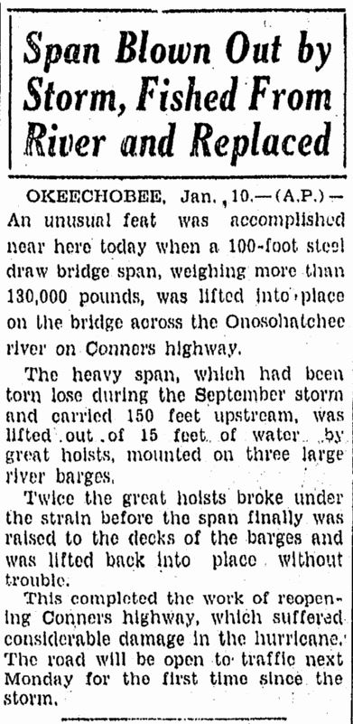
When the posterior wall of the eye crossed the area, the flood situation was reversed and the flood broke the dikes on the northern bank of the lake, causing similar flooding there, albeit to a lesser extent. Route 98 , then known as Connor's Highway, had to be closed for several months because the bridge over the Okeechobee River at Taylor Creek was washed 45 m upriver during the storm. In Okeechobee County , lakeside homes were destroyed by the storm surge, and in the city of Okeechobee , residential buildings were badly damaged or demolished by winds of 140 km / h or more, with brick or concrete structures usually only slightly damaged. A number of three-story commercial buildings collapsed during the storm. The towns of Clewiston and Moore Haven were flooded, but most of the building damage here was due to high winds. Almost all roads became impassable and communications links were almost completely wiped out. In total, there were 27 registered victims of the hurricane in Okeechobee County.
On Kreamer Iceland many residents were informed about the storm when it was already too late to leave the area. In some houses, 20 to 30 people seek refuge, and later they stood on tables and chairs to stay afloat. Many of the houses were washed from their foundations until they got stuck in rows of pine trees, others swam up to a kilometer away. Even so, only one person drowned on the island. The residents of Torry Island also did not have enough time to prepare adequately for the storm. They tried to get to safety, but the causeway was already flooded, forcing 23 people to seek refuge in a canning factory . When the water penetrated the building, those trapped were forced to climb into the roof stalls. Eventually the flood pushed the structure into an adjacent canal; ten people drowned, but 13 others were mostly saved by clinging to a boat and trees, and one woman survived by being tied to a telegraph pole. Other survivors were swept away by the flood; a teenager, for example, was washed from the canning factory to the Everglades Experiment Station in Belle Glade - over a distance of eight miles. A number of people died on Ritta Island who had successfully escaped to the roofs of their houses, but were killed there by falling trees or bitten by water moccasin otters.
In South Bay almost all houses were destroyed, and several public buildings were covered. At least 160 residents of the city were killed by the effects of the storm. The city of Okeelanta was plagued by floods and fires several times during the 1920's. Eventually, the city was heavily flooded during the hurricane and subsequently abandoned by its residents. Bean City was also destroyed during the hurricane, but was later rebuilt by Arthur Wells . Only four large royal palms of the Sebring Farms remained upright. Only one hotel survived the hurricane in Miami Locks . 99 people died in this place. In Chosen , only two survived in a house where 19 people had sought refuge. Twenty others had taken shelter in a house whose roof was covered. Another house, full of people seeking refuge, was carried away nearly a kilometer by the flood until it caught on a railway embankment. Only then did the people in the house notice that it had swam away.
.jpg)
The flood water remained for several weeks, which severely affected the clean-up work. The funeral services were quickly overloaded, so that many of the bodies had to be buried in mass graves. About 75% of the dead were migrant workers employed in agriculture, making identification of the dead and missing very difficult. For this reason, the number of victims could not be precisely determined. The American Red Cross estimated the number of casualties at 1836, which was the official figure of the United States National Weather Service for many years . Older sources give the total number of victims, including those in the Caribbean , as 3411. As of 2003, the National Weather Service has reported "at least" 2500 casualties, making the Okeechobee hurricane the second-highest killing natural disaster in the United States after the Galveston hurricane (1900) . A mass grave in Port Mayaca Cemetery east of Port Mayaca contains the remains of 1,600 victims of the hurricane.
Central and North Florida
In Fort Myers , the property damage was largely minor and was mostly limited to a large number of boats and fishing trawlers along the shoreline. Almost all Tampa cigarette factories had to shut down because wind and rain brought too much moisture into the structures. The fishing cutter Wallace A. McDonnell ran aground off the coast at Piney Point ; the crew survived. The Cuban freighter Isabel Alvado sank off Boca Grande . The crew was rescued by the US Coast Guard and later deported. In Martin County , the bridge between Stuart and Palm City was badly damaged and closed to traffic as a result. The crossing of the St. Lucie River one was ferry set, which was operated until the completion of the bridge repair in the summer 1929th In Fort Pierce , the damage was largely limited to the areas on the water. A warehouse, fish processing plants, docks and a bridge over the Indian River were destroyed, and several other structures were roofed over. The material damage in the city totaled about 150,000 US dollars (in today's prices 2,234,800 US dollars in prices of 1928).
In the hinterland of central and northern Florida, the effects were limited to damage to agriculture, particularly lemons, and to wind damage to buildings. 200 telephone poles were knocked down between Sebring and Lake Wales . In Bartow shop windows were smashed and signage was torn down; several roofs and chimneys were damaged. Gusts of up to 110 km / h swept over Lakeland . Many trees were uprooted and several houses were damaged, including the hospital and commercial establishments. On the Florida Southern College (FSC) campus , the north side of the gymnasium collapsed and other buildings on campus were less damaged. The lemon trees around the FSC lost most of their fruits. Property damage in Lakeland was $ 50,000 (1928; in today's prices $ 744,900). Wind speeds of up to 80 km / h affected Jacksonville and caused little damage in Jacksonville Beach .
Elsewhere
The damage caused by the hurricane in the United States outside of Florida was minor. In Georgia, low roads near Savannah were flooded. In addition, strong winds knocked over trees and power lines. Heavy rain occurred from eastern Florida across the coastal areas in Georgia and the two Carolina states to southeastern Virginia. The highest total rainfall was measured in Darlington , South Carolina at 318 mm . The storm caused flooding in North Carolina and brought strong storms and a 2.1 m storm surge to the Norfolk , Virginia area. After the hurricane lost its tropical properties, the wind field became very large. Wind speeds of 122 km / h were recorded in Atlantic City , New Jersey , although the storm center remained far from the city.
Aftermath
Immediately after the storm broke through, aid was sent from nearby cities. Early on September 18, a train carrying 20 doctors and 20 nurses left Miami for West Palm Beach. The Miami Red Cross Citizens Relief Committee was formed to help those affected by the storm. It sent bread, milk, coffee, and sugar, as well as blankets, hammocks, and medical supplies. In the first emergency train also sitting Democratic Senator Joseph T. Robinson , who in the presidential election that year was nominated for the office of vice president. At least 100 people were brought to Miami for medical treatment. In Lake Worth, 25 injured were treated at the Gulf Stream Hotel and the local fire station.
Aspects of racial segregation

Although the storm destroyed everything in its way, the number of casualties in Florida was by far highest in the economically poorer and at the same time low-lying areas around the lake, including Belle Glade, Chosen, Pahokee, South Bay and Bean City . Around 75% of the victims were migrant farm workers, mostly black. Blacks did most of the clean-up work, too, and of the few coffins that were available, almost all of them were used for white bodies. Funerals were segregated . The white victims of the hurricane were buried in order in Woodlawn Cemetery in downtown West Palm Beach, and only here was a memorial to the dead erected.
The black dead were either cremated or buried in mass graves such as in West Palm Beach or Port Mayaca. Much later, a resident of the city of West Palm Beach founded a citizens' group to fight for the memory of the black victims of the storm, and in 2000 the city government bought the site of the mass grave and began planning a memorial. The Hurricane of 1928 African American Mass Burial Site was listed on the National Register of Historic Places two years later , and a state marker was placed in 2003 to mark the 75th anniversary of the hurricane. The effects of the hurricane on black migrant workers were processed by Zora Neale Hurston in the novel Before Their Eyes They saw God .
Improved building codes
The aftermath of the Florida coastal hurricane revealed that well-constructed buildings with shutters suffered virtually no damage from the wind, while the wind caused serious structural problems in simpler buildings. Buildings with a sturdy frame and those made of steel, concrete, brick or stone were for the most part impervious to the wind and the use of shutters prevented damage to windows and interiors. Since a similar pattern was discovered in the 1926 Miami hurricane , a permanent result of the 1928 storm was improving building codes in South Florida.
Flood protection

To counteract the effects of another catastrophe like the Miami Hurricane in 1926, the Florida State Legislature decided to create the Okeechobee Flood Control District, which should undertake flood control measures with the US Army Corps of Engineers . After President Herbert Hoover found out in person, the Corps drew up a new plan to build flood channels, control locks and high levels along the shores of Lake Okeechobee. A long-term system has been devised for the purposes of flood control, water conservation, salinization prevention and conservation of fish and game populations. One of the measures was the construction of the Herbert Hoover Dike . In the present, there are growing concerns about the stability of the levee as long-term observations indicate problems from piping and erosion , and water seepage has been reported after heavy rainfall. Suggested solutions to these problems include building a berm on the land-facing side of the dike, the nature of which would allow seepage but prevent piping.
See also
literature
- Kleinberg, Eliot. (2003) Black Cloud: The Great Florida Storm of 1928 . Carroll & Graf Publishers. ISBN 0-7867-1146-9
Web links
- National Weather Service Miami - South Florida: Memorial Web Page for the 1928 Okeechobee Hurricane ( English ) National Oceanic and Atmospheric Administration.
Individual evidence
- ↑ a b c d e f g h i j k l m Chris Landsea: Documentation of Atlantic Tropical Cyclones Changes in HURDAT ( English ) National Hurricane Center Hurricane Research Division. April 2014. Retrieved August 28, 2016.
- ^ David Roth, Hugh Cobb: Virginia Hurricane History: Early Twentieth Century ( English ) In: Virginia Hurricane History . Retrieved January 21, 2017.
- ↑ a b c d e f g h i j k l m n o p q Charles Mitchell: The West Indian Hurricane of September 10-20, 1928 . (PDF) In: Monthly Weather Review . September 1928, pp. 347-350. bibcode : 1928MWRv ... 56..347M . doi : 10.1175 / 1520-0493 (1928) 56 <347: TWIHOS> 2.0.CO; 2 . Retrieved April 29, 2010.
- ^ A b c NHC Hurricane Research Division (Ed.): Atlantic hurricane best track ("HURDAT") ( English ). Retrieved February 17, 2006.
- ^ A b Orlando Pérez: Notes on the Tropical Cyclones of Puerto Rico ( English , PDF) San Juan, Puerto Rico National Weather Service. 1970. Retrieved August 28, 2016.
- ^ National Hurricane Center: Atlantic hurricane best track (Hurdat) ( English ) Hurricane Research Division. Atlantic Oceanographic and Meteorological Laboratory. National Oceanic and Atmospheric Administrations Office of Oceanic & Atmospheric Research. April 2018. Retrieved May 9, 2018.
- ↑ National Hurricane Center: Continental United States Hurricanes (Detailed Description) ( English ) United States National Oceanic and Atmospheric Administration's Office of Oceanic & Atmospheric Research. February 2015. Retrieved August 28, 2016.
- ^ Eliot Kleinberg : Black Cloud: The Great Florida Storm of 1928 . Carroll & Graf Publishers, 2003, ISBN 978-0-7867-1146-8 , p. 87.
- ↑ National Climatic Data Center: List of Category 5 Atlantic Hurricanes (1886 - Present) ( English ) National Oceanic and Atmospheric Administration. Archived from the original on May 23, 2012. Info: The archive link was inserted automatically and has not yet been checked. Please check the original and archive link according to the instructions and then remove this notice. Retrieved January 7, 2017.
- ↑ a b c d e Frank Mújica-Baker: Huracanes y Tormentas que han afectado a Puerto Rico ( Spanish ) Estado Libre Asociado de Puerto Rico, Agencia Estatal para el manejo de Emergencias y Administración de Desastres. Pp. 4, 9, 10. Accessed August 30, 2016.
- ^ A b William G. Innanen: A Condensed History of Montserrat . Archived from the original on December 1, 2006. Retrieved January 21, 2017.
- ^ A b Vincent K. Hubbard: Swords, Ships & Sugar: History of Nevis 2002.
- ↑ National Hurricane Center: The Deadliest Atlantic Tropical Cyclones, 1492-1996 ( English ) 1995/1997. Retrieved February 13, 2006.
- ^ Don R. Hoy: Agricultural Land Use of Guadeloupe, Issue 12 . National Academies Press , Washington, DC 1961, p. 64 (Accessed 2016-08-58).
- ↑ a b c d Oliver L. Fassig: San Felipe – The Hurricane of September 13, 1928, at San Juan, PR . In: American Meteorological Society (Ed.): Monthly Weather Review . 56, No. 9, December 8, 1928, pp. 350-352. bibcode : 1928MWRv ... 56..350F . doi : 10.1175 / 1520-0493 (1928) 56 <350: SFHOSA> 2.0.CO; 2 . Retrieved August 30, 2016.
- ^ US Southern Command: Hurricane Preparedness: History . US Army. Archived from the original on December 17, 2007. Retrieved August 30, 2016.
- ↑ Stuart B. Schwartz: The 1928 Hurricane and the Shaping of the Circum-Caribbean Region ( English ) In: ReVista: Harvard Review of Latin America . The David Rockefeller Center for Latin American Studies, Harvard University .. Winter 2007. Retrieved January 7, 2017.
- ↑ a b c d e f g Wayne Neely: The Great Okeechobee Hurricane of 1928 ( English ). iUniverse, Bloomington, Indiana 2014, ISBN 978-1-4917-5446-7, (Retrieved May 7, 2015).
- ↑ The deadliest, costliest and most intense United States tropical cyclones from 1851 to 2010 (and other frequently requested hurricane facts) ( English , PDF) In: NOAA Technical Memorandum NWS NHC-6 . National Oceanic and Atmospheric Administration. August 10, 2011. Retrieved January 10, 2017.
- ^ Hurricane Research Division: All US Hurricanes (1851–2007) ( English ) National Oceanic and Atmospheric Administration . 2008. Retrieved January 7, 2017.
- ↑ The Storm: 1928 Remembered ( English ) Historical Society of Palm Beach County. S. 9. 2008. Archived from the original on July 26, 2011. Retrieved January 22, 2017.
- ↑ a b c d e Palm Beach Hurricane-92 Views ( English ) American Auto Chrome Company. 1928. Retrieved June 27, 2015.
- ↑ Hurricane Hits City Sunday (English) . In: Fort Lauderdale Daily News , September 17, 1928. Retrieved May 9, 2015.
- ↑ a b 36 Lives Lost is Storm Toll Over Florida (English) . In: Miami Herald , September 18, 1928. Retrieved May 8, 2015.
- ^ Few Buildings Escape Damage From Hurricane . In: The Palm Beach Post , September 18, 1928.
- ^ National Weather Service: Memorial Web Page for the 1928 Okeechobee Hurricane ( English ) National Weather Service . June 29, 2009. Retrieved February 21, 2015.
- ↑ a b c d Jay Barnes: Florida's Hurricane History ( English ). University of North Carolina Press , 2007, ISBN 978-0-8078-3068-0 , p. 129, (Accessed May 12, 2015).
- ↑ The Storm: 1928 Remembered (Teacher's Guide) ( English ) Historical Society of Palm Beach County. S. 21. 2008. Archived from the original on March 4, 2016. Info: The archive link was inserted automatically and has not yet been checked. Please check the original and archive link according to the instructions and then remove this notice. Retrieved March 10, 2015.
- ^ Jeff Klinkenberg: A storm of memories (English) . In: St. Petersburg Times , July 12, 1992. Archived from the original on July 17, 2012. Retrieved May 6, 2015.
- ↑ a b c Nicole Brochu Sterghos: Florida's Forgotten Storm: the Hurricane of 1928 ( English ) South Florida Sun-Sentinel. 2003. Retrieved April 6, 2008.
- ^ Span Blown Out By Storm, Fished From River and Replaced (English) . In: The Tampa Tribune , January 10, 1929. Retrieved May 10, 2015.
- ↑ a b Okeechobee Deaths Laid To Big Wave (English) . In: The Tampa Tribune , September 19, 1928. Retrieved May 13, 2015.
- ↑ Storm Cannot Be Exaggerated Says Red Cross (English) . In: The Tampa Tribune , September 19, 1928. Retrieved May 13, 2015.
- ↑ Lee Allyn Davis: Natural Disasters ( English ). Infobase Publishing, New York City, New York January 1, 2009, ISBN 978-1-4381-1878-9 , p. 296 (Retrieved September 9, 2015).
- ^ Okeelanta ( English ) Historical Society of Palm Beach County. 2009. Retrieved June 27, 2015.
- ↑ Mike Abrams: Bean City (English) . In: The Palm Beach Post , May 12, 1970.
- ↑ Jack Dadswell: Storm Effects Told In Survey Made By Radio (English) . In: St. Petersburg Times , September 18, 1928, p. 2. Retrieved July 24, 2015.
- ↑ Storm Passes To North With Force Lessened (English) . In: The Tampa Tribune . Retrieved June 27, 2015.
- ↑ Smack Around, Schooner Sinks During Storm (English) . In: The Tampa Tribune , September 18, 1928. Retrieved June 27, 2015.
- ↑ Alice L. and Greg E. Luckhardt: Historical Vignettes: Chillingworth's Palm City Development (English) . In: Treasure Coast Newspapers , December 10, 2013. Retrieved July 25, 2015.
- ↑ $ 50,000 Damage Caused to Lakeland Property (English) . In: The Tampa Tribune . Retrieved June 27, 2015.
- ↑ Jacksonville and Brunswick, Ga. Are Whipped by wind (English) . In: St. Petersburg Times , September 18, 1928, p. 1. Retrieved July 24, 2015.
- ↑ United States Corps of Engineers: Storm Total Rainfall In The United States . War Department, 1945, pp. SA 2-15.
- ^ David Roth and Hugh Cobb: Virginia Hurricane History . National Oceanic and Atmospheric Administration . Archived from the original on January 8, 2008. Retrieved September 22, 2017.
- ↑ 33 Known Dead in Storm Area; Troops to Aid (English) . In: The Tampa Tribune , September 18, 1928. Retrieved January 6, 2017.
- ↑ Miami prompt to Give Aid in knitting Area (English) . In: Miami Herald , September 18, 1928. Retrieved May 12, 2015.
- ↑ a b c The Hurricane of 1928 ( English ) Historical Society of Palm Beach County. 2009. Retrieved January 6, 2017.
- ↑ a b Deborah Sharp: Storm's path remains scarred after 75 years (English) . In: USA Today , September 4, 2003. Retrieved January 6, 2017.
- ↑ Florida Properties - African American History Month ( English ) National Park Service . Retrieved January 6, 2017.
- ↑ Betty Nelander: The Hurricane of 1928: Category 4 hurricane scarred Palm Beach ( English ) 2008. Archived from the original on September 20, 2008. Retrieved January 6, 2017.
- ↑ a b Lake Okeechobee and The Okeechobee Waterway ( English ) US Army Corps of Engineers South Florida Operations Office. Archived from the original on June 9, 2007. Retrieved August 3, 2000.
- ↑ Lake Okeechobee and the Herbert Hoover Dike ( English , PDF) US Army Corps of Engineers Jacksonville District. Archived from the original on October 3, 2008. Retrieved January 6, 2017.