Orge (Saulx)
| Orge | ||
|
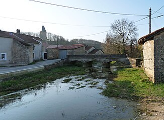
The river in Ribeaucourt |
||
| Data | ||
| Water code | FR : F5510600 | |
| location | France , Grand Est region | |
| River system | His | |
| Drain over | Saulx → Marne → Seine → English Channel | |
| source | in the municipality of Gillaumé 48 ° 28 '2 " N , 5 ° 21' 21" O |
|
| Source height | approx. 338 m | |
| muzzle | in the municipality of Le Bouchon-sur-Saulx in the Saulx (river) coordinates: 48 ° 36 '18 " N , 5 ° 14' 43" E 48 ° 36 '18 " N , 5 ° 14' 43" E |
|
| Mouth height | approx. 240 m | |
| Height difference | approx. 98 m | |
| Bottom slope | approx. 3.8 ‰ | |
| length | approx. 26 km | |
The Orge is a river in France that runs through the Haute-Marne and Meuse departments in the Grand Est region .
course
It rises in the municipality of Gillaumé and generally drains in a north-westerly direction. On its way, it often carries small amounts of water on the surface or in sections completely seeps into the dry subsoil. After around 26 kilometers, it finally flows into the Saulx as a right tributary in the municipality of Le Bouchon-sur- Saulx .
Places on the river
(Order in flow direction)
Web links
Commons : Orge - collection of images, videos and audio files
