
Ostlutter
|
Ostlutter
Flecken Lutter am Barenberge
Coordinates: 51 ° 59 ′ 6 ″ N , 10 ° 17 ′ 26 ″ E
|
|
|---|---|
| Height : | approx. 190 m above sea level NN |
| Area : | 4.46 km² |
| Residents : | 377 (Jun. 30, 2018) |
| Population density : | 85 inhabitants / km² |
| Incorporation : | March 1, 1974 |
| Postal code : | 38729 |
| Area code : | 05383 |
 Half-timbered house in the town center
|
|
Ostlutter is a district of the borough Lutter am Barenberge in the district of Goslar , Lower Saxony. In April 2016 the place had 379 inhabitants.
geography
Ostlutter is located in the northwestern Harz foreland at about 190 meters above sea level. NN. One and a half kilometers to the west is the center of Lutter am Barenberge. The Liebenburg district of Ostharingen is five kilometers east-northeast.
The place is at the southwestern end of the wooded ridge of Wahrenberg, part of the Innerstebergland .
history

The manor in Ostlutter came through the Counts of Schwicheldt auf Söder in the 20th century to the Counts of Hardenberg , who currently manage it.
On March 1, 1974, Ostlutter was incorporated together with Nauen in the Lutter am Barenberge area.
Population development
The table shows the population as of June 30th for 2009, 2012 and 2018 and December 31st for 2006, 2010, 2011, 2013 and 2014 as well as April 1st for 2016 and October 1st for 2017.
| development | year | Residents | year | Residents |
|---|---|---|---|---|
 |
2006 | 376 | 2009 | 382 |
| 2010 | 283 | 2011 | 282 | |
| 2012 | 278 | 2013 | 295 | |
| 2014 | 381 | 2016 | 379 | |
| 2017 | 408 | 2018 | 377 |
Economy and Infrastructure
Transport links
Ostlutter can be reached via the state road 500 from Lutter am Barenberge and Ostharingen.
Tourism and sightseeing
In the center of the village on the main street there is a restaurant, the Dorfkrug. There are also several ponds in the village, including the Großer Rösenteich and the Försterteich.
The Ostlutter sandstone quarry, closed in 1952, is one kilometer from the northern outskirts. This is where the Hilssandstein occurs, which is typical for the region of southeast Lower Saxony. Hilssandstein occurring at this demolition site is known as Lutter sandstone .

Restaurant "Dorfkrug"
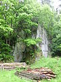
In the Ostlutter sandstone quarry
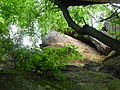
Rock formation from the region's typical Hils sandstone in the quarry near Ostlutter


Individual evidence
- ^ Residents of the communities and districts - Goslar district , accessed on March 17, 2019
- ↑ PDF document of the Lutter am Barenberge joint community .
- ↑ PDF document of the Lutter am Barenberge joint community .
- ↑ PDF document of the district of Goslar .
- ↑ PDF document of the district of Goslar .
- ↑ PDF document of the Lutter am Barenberge joint community .
- ↑ PDF document of the district of Goslar .
- ↑ PDF document of the Lutter am Barenberge joint community , accessed on November 15, 2015.
- ↑ Figures, data, facts on the Lutter am Barenberge website , accessed on March 5, 2018.
- ↑ Article on Hilssandstein in Wikipedia .
Lutter am Barenberge with Rhode | Nauen with the Pöbbeckenmühle | Ostlutter