Ōtākou
| Ōtākou | ||
| Geographical location | ||
|
|
||
| Coordinates | 45 ° 48 ′ S , 170 ° 42 ′ E | |
| Region ISO | NZ-OTA | |
| Country |
|
|
| region | Otago | |
| District | Dunedin | |
| Ward | Central Ward | |
| Residents | 50 | |
| height | 10 m | |
| Post Code | 9077 | |
| Telephone code | +64 (0) 3 | |
| Photography of the place | ||
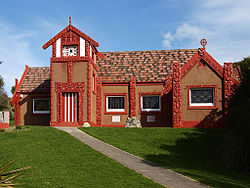
 Whare Runanga Tamatea (meeting house) from Ōtākou |
||
Ōtākou is a historic Māori settlement in the urban area of Dunedin on the South Island of New Zealand .
Origin of name
The name of the settlement comes from the Māori language and is composed of the terms " O " for place and " takou " for red ocher. Ocher here means the red earth color and so the name can be translated as "place of the red earth". Ōtākou was also the namesake for the Otago region . Since the "k" in the Māori language of the South Island sounds more like a "g", European immigrants formed Otago from it .
geography
The settlement is located around 18 km east-northeast of the city center of Dunedin on Otago Harbor on the Otago Peninsula . The entrance to the natural harbor is around 2 km northeast of the settlement and Taiaroa Head is another kilometer away.
history
Seal hunter John Boultbee was arguably the first European to document the existence of Māori settlements around Otago Harbor in the 1820s. In 1831 the Weller brothers followed , who came from Sydney and opened a whaling station on the banks of Otago Harbor not far from the settlement of Ōtākou , which became known as Wellers Rock .
On June 13, 1840 in Otakou Marae of Ngai Tahu a copy of the Captain William Hobson sent and Thomas Bunbury over brought Treaty of Waitangi signed.
In July 1844 the British civil engineer and surveyor Frederick Tuckett came to the Ngai Tahu in Ōtākou and on July 31, on behalf of the New Zealand Company , bought 162 hectares of land, the so-called Ōtākou block , which also included the settlement Ōtākou , the Ngai for £ 2,400 Tahu and recommended the area around Otago Harbor to the Scottish settlers of the Free Church of Scotland as a suitable settlement area.
With the arrival of the first Scottish settlers in Port Chalmers in 1848 , the first big step towards organized settlement around Otago Harbor and beyond was taken. At that time the settlement Ōtākou was already recorded in the maps of the settlers and in the modification Otago became the namesake for an entire region. On December 26, 1848, the then-opted governor of the colony New Zealand , Sir George Edward Gray finally, the wishes of the Scottish settlers to meet, and for the newly developed settlement area, starting from the coast, over Dunedin to the hinterland, māorischen name Otago to forgive . Ignorance or ignorance must have led to the naming, because the Māori still call the same country in their language Araiteuru , named after the Arai Te Uru Waka from Hawaiki .
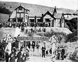
The settlement of Ōtākou still exists and has about 50 inhabitants. The Māori Church, which was built in 1864 by Reverend Johann Friedrich Riemenschneider (1817–1866), a German missionary, and a marae (meeting place) with the Whare Runanga (meeting house) are still located in the small settlement .
literature
- Alexander Hare McLintock : The History of Otago . Otago Centennial Historical Publications , Dunedin 1949 (English).
- WA Taylor : Otakou . In: Lore and History of the South Island Maori . Bascands Ltd , Christchurch 1950, p. 130–140 (English, online [accessed September 14, 2017]).
- Thomas Arthur Pybus : Maori and Missionary - Early Christian Missions in the South Island of New Zealand . Reed Publishing , Wellington 1954 (English).
- Alexander Hare McLintock : Otakou - Otago . In: Alexander Hare McLintock (Ed.): An Encyclopaedia of New Zealand . Wellington 1966 ( online [accessed September 14, 2017]).
- Hardwicke Knight : Otago Peninsula - A Local History . Self-published, Dunedin 1978 (English, Author's Edition, No. 113, signed limited edition of 200 copies, Broad Bay, Otago Peninsula ).
- George Griffiths, Maarire Goodall : Maori Dunedin . Otago Heritage Books , Dunedin 1980 (English).
- Peter Entwisle : Behold the Moon, The European Occupation of the Dunedin District 1770-1848 . Port Daniel Press , Dunedin 1998, ISBN 0-473-05591-0 (English).
- Helga Neubauer: Otakou . In: The New Zealand Book . 1st edition. NZ Visitor Publications , Nelson 2003, ISBN 1-877339-00-8 , pp. 833 f .
Web links
- Otakou Marae . Pacific History Association, archived from the original onJuly 15, 2011; accessed on September 3, 2014(English, original website no longer available).
- Te Maire Tau : Ōtākou marae . In: Te Ara - the Encyclopedia of New Zealand . Ministry for Culture & Heritage , February 8, 2005, accessed September 14, 2017 .
Individual evidence
- ^ Neubauer: Otakou . In: The New Zealand Book . 2003, p. 834 .
- ^ A b McLintock : Otakou - Otago . In: An Encyclopaedia of New Zealand . 1966.
- ↑ Topo250 maps . Land Information New Zealand , accessed September 14, 2017 .
- ↑ Taylor : Otakou . In: Lore and History of the South Island Maori . 1950, p. 130 .
- ↑ Our Harbor . Te Rūnanga o Ōtākou , accessed September 14, 2017 .


