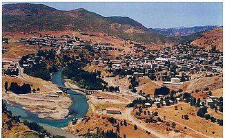
Pülümür Çayı
|
Pülümür Çayı Harçîk Çayı |
||
|
Confluence of the Pülümür Çayı (below) into the Munzur Çayı |
||
| Data | ||
| location | Tunceli ( Turkey ) | |
| River system | Euphrates | |
| Drain over | Munzur Çayı → Peri Çayı → Murat → Euphrates → Shatt al-Arab → Persian Gulf | |
| Headwaters |
Munzur Mountains west of Pülümür 39 ° 32 ′ 24 ″ N , 39 ° 47 ′ 33 ″ E |
|
| Source height | approx. 2200 m | |
| muzzle |
Munzur Çayı near Tunceli Coordinates: 39 ° 6 ′ 1 ″ N , 39 ° 33 ′ 15 ″ E 39 ° 6 ′ 1 ″ N , 39 ° 33 ′ 15 ″ E
|
|
| length | 69 km | |
| Medium-sized cities | Tunceli | |
| Communities | Pülümür | |
The Pülümür Çayı (also Harçîk Çayı ) is a left tributary of the Munzur Çayı in the eastern Turkish province of Tunceli .
The Pülümür Çayı rises west of the Pülümür district administrative center on the slopes of the Avcı Mountains in the Munzur Mountains . The river valley is initially steep and narrow. In the upper reaches, the river passes the town of Pülümür and then flows over a distance of 65 km in a south-westerly direction through the mountains. The Pülümür Çayı finally meets the Munzur Çayı flowing in from the northwest near the provincial capital Tunceli . The Pülümür Çayı has a length of 69 km. So far, the river has been spared from dams and dams. The D885 trunk road , an important road connection between Erzincan in the Karasu Valley and Tunceli, runs in the Pülümür Çayı Valley.
The Pülümür Çayı is nourished by meltwater and numerous tributaries and therefore carries a lot of water.
