Munzur Çayı
|
Munzur Çayı Munzur Suyu, Munzur Irmağı |
||
|
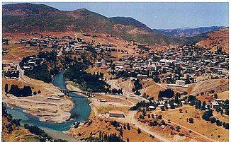
Munzur Çayı in Tunceli (Summer 2006) |
||
| Data | ||
| location | Tunceli ( Turkey ) | |
| River system | Euphrates | |
| Drain over | Peri Çayı → Murat → Euphrates → Shatt al-Arab (Arvandrud) → Persian Gulf | |
| source |
Munzur Mountains 39 ° 24 ′ 17 ″ N , 39 ° 3 ′ 14 ″ E |
|
| Source height | approx. 2500 m | |
| muzzle |
Keban Dam Coordinates: 38 ° 57 '23 " N , 39 ° 33' 38" E 38 ° 57 '23 " N , 39 ° 33' 38" E |
|
| Mouth height | approx. 850 m | |
| Height difference | approx. 1650 m | |
| Bottom slope | approx. 11 ‰ | |
| length | 144 km | |
| Drain |
MQ |
87 m³ / s |
| Left tributaries | Pülümür Çayı | |
| Reservoirs flowed through | Uzunçayır Dam | |
| Medium-sized cities | Tunceli | |
| Communities | Ovacık | |
|
Confluence of the Pülümür Çayı (below) into the Munzur Çayı near Tunceli |
||
The Munzur Çayı (also Munzur Suyu or Munzur Irmağı ) is a river in Eastern Turkey .
The Munzur Çayı rises in the Munzur Mountains in the north of the Tunceli province . It flows past the district town of Ovacık in an easterly direction. Later he turns south and cuts through the mountains. At Tunceli the Pülümür Çayı meets the river coming from the northeast. The Munzur Çayı will then be dammed by the Uzunçayır dam over a length of 18 km. The reservoir of the Keban Dam begins 4 km below the dam . Originally the Munzur Çayı flowed a further 18 km to its confluence with the Peri Çayı , which in turn flowed into the Murat . Today the lower reaches of these rivers are dammed by the Keban dam. The length of Munzur Çayı is given as 144 km. The mean discharge is 87 m³ / s. In April the average discharge is 398 m³ / s, in October it is only 44 m³ / s. The Munzur Çayı is part of the Munzur Vadisi National Park .


