
Paddington, New South Wales
| Paddington, New South Wales | |||||||||
|---|---|---|---|---|---|---|---|---|---|
 Paddington City Hall |
|||||||||
|
|||||||||
|
|||||||||
|
|||||||||
|
|||||||||
|
|||||||||

Paddington is an inner-city east suburb of Sydney in the Australian state of New South Wales and is three kilometers east of the Sydney Central Business District . The suburb belongs partly to the City of Sydney and partly to the Municipality of Woollahra . The name is colloquially often shortened to "Paddo".
Paddington is mainly on the north side of a ridge of hills that runs along Oxford Street. Darlinghurst to the west, Centennial Park and Woollahra to the east, Edgecliff and Kings Cross to the north and Moore Park to the south .
history
Aboriginal culture
The present suburb of Paddington is on parts of land linked to the history and rituals of the Cadigal , who belonged to the Eora language group and were also the traditional owners of the land that is now the Central Business District. The ridge on which today's Oxford Street runs was used as a path by the indigenous people.
Most of the Aboriginal people in Sydney were killed by a smallpox epidemic in 1789 , a year after the First Fleet arrived . British settler records from this period indicate that only three members of the Cadigal Tribe survived the epidemic; however, some anthropologists believe that the tribe went to other tribal areas in the Eora language group area. Native American history is sparse, but it is known that at the time Robert Cooper began building his house, around 200 Koori were living in Woolloomooloo's cabins that Governor Lachlan Macquarie had built for them.
Settlement by Europeans

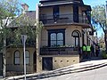
In the early 1820s, gin distiller and ex-convict Robert Cooper built a large Georgian- style house on the crest of the hill that runs through what is now Paddington, from which there were good views. Cooper named the area after the London Borough of Paddington and his residence Juniper Hall . The first houses were built around the Victoria Barracks. Towards the end of the 19th century, mainly terraced houses were built in which the burgeoning working-class population and the middle class settled. Over time, each parcel was built on and the suburb became overpopulated. Paddington's unfavorable structure continued until gentrification in the 1960s. At this time the area was developing bohemian aspects and an artist community attracted mostly creative and alternative residents. In the present, Paddington is an example of unplanned urban renewal , with the desired location and heritage charm contributing to a thriving real estate market. Shoemaker's workshops and fabric shops have given way to designer fashion and food specialties.
Trade and commerce
Paddington is a lively, cosmolitic part of the Eastern Suburbs on Oxford Street , one of Sydney's arteries. The suburb is one of the most historic and culturally diverse districts of the capital of New South Wales and is known for the numerous boutiques and fashion shops as well as cafes and restaurants, which are mainly grouped around the intersection of Five Ways .
Art market
An art market is held every Saturday on the grounds of the Grade II listed Paddington Uniting Church and the adjacent Paddington Public School on Oxford Street. Here, contemporary Australian art, handicrafts and fashion are sold directly to around 250 stalls.
traffic
Paddington is mainly served by public transport by buses that run on Oxford Street. The bus routes run via Darlinghurst to Circular Quay and Central Station and to Bronte , Bondi or Bondi Junction in the opposite direction.
Attractions
Paddington Town Hall
Paddington Town Hall was built in the late 19th century at a cost of £ 15,000 . Inaugurated in 1891, it is an example of European architecture in Sydney. The clock tower is 32 meters high and, standing on Oxford Street, dominates the silhouette of Paddington.
The dials facing east, south, and west show the time in Roman numerals , but on the north side facing Oxford Street the digits have been replaced with: 1: D , 2: U , 3: S , 4: T , 5: H , 6: e , 7 VII , 8: e , 9: D , 10 V , 11 A , 12: R . This was done to celebrate the coronation of Edward VII and starting with where the VIII would normally be, reads EDVARDUS THE VII .
The clock was started on Wednesday, August 30th, 1905 by Joseph Carruthers , the Prime Minister of New South Wales , who mentioned the signing of the Treaty of Portsmouth and said he thought “the day of peace between Russia and Japan was told is a good day to start the clock "and" hopes there will be peace and benevolence on earth as long as the clock keeps ticking ".
The former town hall, where today's Rugby Club Sydney Roosters was founded in 1908 , is now home to radio studios, a cinema and a library.
Victoria Barracks

The Victoria Barracks are an Australian Army facility set back south of Town Hall on Oxford Street. It was built by forced laborers from sandstone blocks broken in Hawkesbury and inaugurated in 1848 after seven years. Even after Australian independence in 1901, the barracks were one of the most important bases for the training of soldiers. In the present, the Headquarters Land Command and Headquarters Training Command is located here.
Sydney Football Stadium
The Sydney Football Stadium at Moore Park Road is located on the southern border Paddington and is home stadium for the Sydney Roosters , the NSW Waratahs and Sydney FC .
Juniper Hall

Juniper Hall was built by Robert Cooper, a former convict, in the 1820s and is Paddington's oldest house. The large dominating structure is diagonally across from Paddington Town Hall. It has been extensively restored and belonged to the National Trust for a while. Today, however, it is used privately and cannot be visited; however, it is visible from Oxford Street.
Oxford Street
The Oxford Street was originally a way of Aborigines to South Head. The street later served as a shopping street. At first, the shops in it served local residents, but now the residents are middle and upper class and the street has become a destination for tourists, many of whom come to Paddington only to shop on Oxford Street.
Monument preservation
The following structures are on the Register of the National Estate :
- Victoria Barracks, Oxford Street
- Paddington Town Hall, Oxford Street
- Paddington Court House, Jersey Road
- Paddington Public School, Oxford Street
- Uniting Church and Parsonage, Oxford Street
- St Matthias Church Group, Oxford Street
- Former Rectory, 495 Oxford Street
- St Matthias Church Hall, Oxford Street
- Royal Hotel, Glenmore Road
Houses

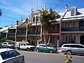
Paddington is known for its Victorian townhouses, most of which degenerated into slums after World War II , but later gentrification meant that these houses are now sought after. The suburb is characterized by a network of interconnected streets and paths, some of which are too narrow for today's road vehicles. In contrast, there are some much wider streets, such as Paddington Street or Windsor Street.
Demographics
At the 2016 census, the population of Paddington was 12,911. The area has a high proportion of residents born outside Australia, with only 59.9% saying they were born here. The others were mostly born in the United Kingdom and New Zealand . 70% of the residents of the suburb live in the Victorian terraced houses typical of the suburb, the rest in apartments.
sons and daughters of the town
- Walter Frederick Gale (1865–1945), banker and astronomer
- Neville Wran (1926-2014), politician
- Valerie Taylor (* 1935), diver, photographer and filmmaker
gallery

Townhouses
Castle Terrace
Corner Restaurant, Hargrave Street

Captain Cook Hotel, Flinders Street
Royal Hotel, Five Ways

Paddington Post Office, Oxford Street

Victoria Barracks Gate

War Memorial, Oxford Street


Web links
literature
- Paddington. Its History, Trade and Industries 1860-1910 . Paddington Municipal Council, 1910 (1st edition). Salux Pty Ltd, 1980 (2nd edition). ( ISBN 0959454411 ).
- Andrew Starr & Janet Morice. Paddington Stories. Andrew Starr & Associates. Australia, 2000. ( ISBN 0646404032 ).
Individual evidence
- ↑ a b c Australian Bureau of Statistics : Paddington ( English ) In: 2016 Census QuickStats . June 27, 2017. Retrieved April 30, 2020.
- ^ Gregory's Street Directory, Gregory's Publishing Company, 2007
- ^ Barani, City of Sydney (2005). Aboriginal People and Place
- ^ Paddington Coronation Proposal: A Town Hall Clock , The Sydney Morning Herald , (Wednesday July 16, 1902), p. 5.
- ^ Paddington Town Hall: Clock for the Tower , The Sydney Morning Herald , (Saturday, May 6, 1905), p. 9.
- ^ Town Clock at Paddington , The Sydney Morning Herald , (Thursday, August 31, 1905), p. 3.
- ^ Australian War Memorial (2005). Australian Military Units: Victoria Barracks (Sydney)
- ^ The Heritage of Australia, Macmillan Company, 1981, pp. 2 / 84-85