
Pampa Grande
| Pampa Grande | |||
|---|---|---|---|
 Arrival of a wedding party in the plaza |
|||
| Basic data | |||
| Residents (state) | 770 pop. (2012 census) | ||
| height | 1291 m | ||
| Post Code | 07-0902-0103-1001 | ||
| Telephone code | (+591) | ||
| Coordinates | 18 ° 5 ′ S , 64 ° 7 ′ W | ||
|
|||
| politics | |||
| Department | Santa Cruz | ||
| province | Florida Province | ||
| climate | |||
 Climate diagram Pampa Grande |
|||

Pampa Grande (or: " Pampagrande ") ( Quechua : " Hatun Pampa ") is a town in the Santa Cruz Department in the South American Andean state of Bolivia .
Location in the vicinity
Pampa Grande is the central place of the district of the same name ( Bolivian : Municipio ) Pampa Grande in the province of Florida . The village is located in the eastern Andean Mountains at an altitude of 1291 m in the foothills of the Cordillera Oriental on the upper reaches of the Río Los Negros , which later flows into the Río Yapacaní .
geography
Pampa Grande lies in the transition area between the Andes mountain range of the Cordillera Central and the Bolivian lowlands. The region's climate is semi-arid, warm and balanced, but because of the altitude it is less hot and humid than in the nearby lowlands.
The mean average temperature of the region is 24.5 ° C (see climate diagram Pampa Grande) and fluctuates only insignificantly between 21 ° C in July and 26 ° C from November to January. The annual precipitation is about 650 mm, with a clearly pronounced dry season from May to October with monthly precipitation below 20 mm, and a short humidity period from December to February with 100 to 120 mm monthly precipitation.
Transport network
Pampa Grande is located at a distance of 176 kilometers by road southwest of the department capital Santa Cruz between the cities of Los Negros and Mataral .
By Pampagrande the 488 km long leads highway Ruta 7 , which connects the two cities of Santa Cruz and Cochabamba connects. The paved Ruta 7 leads from Santa Cruz via La Guardia and La Angostura to Samaipata and then on via Mairana and Los Negros to Pampa Grande . To the west the road continues via Mataral, Comarapa and Epizana to Sacaba and Cochabamba.
population
The population of the place has increased by more than a third in the past two decades:
| year | Residents | source |
|---|---|---|
| 1992 | 558 | census |
| 2001 | 766 | census |
| 2012 | 770 | census |
Due to the historically grown population distribution, the region still has a certain proportion of Quechua population, in the municipality of Pampa Grande 11.7 percent of the population speak the Quechua language.
Photo gallery
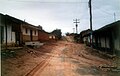
Unpaved road
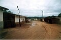
Mud-covered street
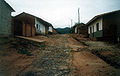
Washed out main street

View of the main street


Individual evidence
- ^ Instituto Nacional de Estadística Bolivia (INE) 1992
- ^ INE - Instituto Nacional de Estadística Bolivia 2001
- ↑ INE - Instituto Nacional de Estadística Bolivia 2012 ( Memento of the original from July 22, 2011 in the Internet Archive ) Info: The archive link has been inserted automatically and has not yet been checked. Please check the original and archive link according to the instructions and then remove this notice.
- ↑ INE social data Santa Cruz 2001 (PDF; 5.2 MB)
Web links
- Relief map of the Vallegrande region 1: 250,000 (PDF; 8.75 MB)
- Municipio Pampa Grande - General Maps No. 70902
- Municipio Pampa Grande - detailed map and population data (PDF; 826 kB) ( Spanish )
- Department Santa Cruz - Social data of the municipalities (PDF; 4.99 MB) ( Spanish )