Pareyer connection channel
The Pareyer Connection Canal (PVK) is a federal waterway of waterway class III in the state of Saxony-Anhalt . It establishes a connection between the Elbe at kilometer 371.50 and the Elbe-Havel Canal at kilometer 351.19 near the towns of Parey on the Elbe and Neuderbe and is 3.33 kilometers long. The canal has a lock just before the Elbe . The Brandenburg Waterways and Shipping Office is responsible for the administration . From the Pareyer connecting canal branch off to the left as the federal waterways Baggerelbe , Neuderbeer Altarm and Altarm Alter Elbarm and to the right as the state waterway, the access to Kühns Loch .
history
In order to shorten the waterway between the fortress city of Magdeburg and the residential cities on the Havel and Spree , the Prussian King Friedrich II initiated studies and plans for the construction of an artificial waterway between the Elbe and Havel through Minister Gröne in 1740. After 1743, construction of the Plauer Canal began.
Due to silting up in the mouth of the Plauer Canal, diving depth problems repeatedly occurred , so that the fairway had to be dredged repeatedly . Between 1883 and 1891 the mouth of the Plauer Canal was finally relocated about 3.5 kilometers up the Elbe, creating the Baggerelbe.
The Elbe-Havel Canal was later created from the Plauer Canal and the Ihle Canal. The way on the waterway between Magdeburg and Berlin was shortened by 150 km. The Plauer Canal flows into the Elbe north of Parey. The section of the Plauer Canal between the Elbe and Elbe-Havel Canal was officially given the current name PVK in 1938. To overcome the different water level heights, a first wooden lock, the old Parey lock , was built near Parey . In the years 1888 to 1892 new Elbe dykes were built near Parey and a new breakthrough was made between the Elbe and Plauer Canal. A new Pareyer lock was built as a two-chamber composite system at a distance of about 1.5 kilometers from the existing one.
The lock
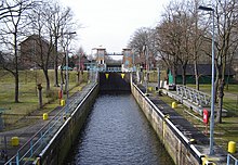
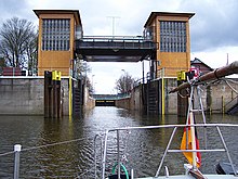
The Parey lock at kilometer 0.80 of the connecting canal is a coupling lock . It is 145 m long and 8.20 m wide. In the middle area it can be closed by an additional mortise gate and thus divided. The height of fall depends on the water level of the Elbe and can fluctuate up to several meters. To ensure flood protection for the canal area, the outer head of the lock is integrated into the Elbe dyke with its lifting gate. The maximum permissible diving depth when passing the lock is 1.85 m. The vehicles must not be longer than 70.00 m and not wider than 8.20 m.
places
On the north bank of the canal are the village of Neudorben and the Bolle shipyard , on the south bank of the village Parey and a loading point for gravel and similar building materials.
bridges
A road bridge leads over the canal and a pedestrian bridge directly at the lock. With medium water in the canal, the lowest clearance height at the pedestrian bridge is 4.00 m. The old railway bridge shortly after the junction from the Elbe-Havel Canal of the former Güsen-Jerichow railway line was dismantled in March 2015.
See also
literature
- Hans-J. Uhlemann: Berlin and the Märkische waterways. Transpress Verlag, Berlin 1987, ISBN 3-344-00115-9 .
- Writings of the Association for European Inland Shipping and Waterways e. V. Various years. WESKA (Western European Shipping and Harbor Calendar), Binnenschifffahrts-Verlag, Duisburg-Ruhrort. OCLC 48960431
cards
- Folke Stender (editor): Sportschifffahrtskarten inland 1. Nautical publication Verlagsgesellschaft, ISBN 3-926376-10-4 .
- W. Ciesla, H. Czesienski, W. Schlomm, K. Senzel, D. Weidner: Shipping maps of the inland waterways of the German Democratic Republic 1: 10,000. Volume 4. Editor: Waterways Authority of the GDR, Berlin 1988, OCLC 830889996 .
Web links
Individual evidence
- ↑ Directory E, serial no. 10 der Chronik ( Memento of the original from July 22, 2016 in the Internet Archive ) Info: The archive link has been inserted automatically and has not yet been checked. Please check the original and archive link according to the instructions and then remove this notice. , Federal Waterways and Shipping Administration
- ↑ Lengths (in km) of the main shipping lanes (main routes and certain secondary routes) of the federal inland waterways ( memento of the original from January 21, 2016 in the Internet Archive ) Info: The archive link was inserted automatically and has not yet been checked. Please check the original and archive link according to the instructions and then remove this notice. , Federal Waterways and Shipping Administration
- ↑ The Plauer Canal ( Memento from June 22, 2007 in the Internet Archive )
- ↑ Elbe-Havel Canal. Historical development. In: wsa-brandenburg.wsv.de. Retrieved April 24, 2020 .
- ^ Reichsverkehrsblatt A dated December 23, 1938, page 191
- ↑ The lock
- ↑ Water level-dependent locks ( memento of the original from January 12, 2016 in the Internet Archive ) Info: The archive link was automatically inserted and not yet checked. Please check the original and archive link according to the instructions and then remove this notice.
- ↑ Schiffswerft Bolle GmbH Derben ( Memento of the original dated June 14, 2015 in the Internet Archive ) Info: The archive link was inserted automatically and has not yet been checked. Please check the original and archive link according to the instructions and then remove this notice.
Coordinates: 52 ° 24 ′ 12 ″ N , 11 ° 58 ′ 39 ″ E


