
Pentes de la Croix-Rousse
| Les Pentes de la Croix-Rousse | |
|---|---|
| - | administration |
| country | France |
| region | Auvergne-Rhône-Alpes |
| city | Lyon |
| Arrondissement | 1. |
| - | location |
| Coordinates | 45 ° 46 ′ 14 "North 4 ° 49 ′ 54" East |
| height | 178 m - 208 m |
| - | Transport links |
| Subway | Metro Lyon C |
| Bus route | C 13 18 , among others |

La Croix-Rousse is the name of one of the three hills of Lyons ( Fourvière (hill) and La Duchère ). It is also the name of one of the originalmunicipalitiesof the Rhône department , which is located on this hill and consists of two different districts:
- The plateau up to 254 m in the 4th arrondissement
- The slopes ( French Les Pentes , part of the 1st arrondissement )
history
The settlement of the slopes of La Croix-Rousse did not begin until the Renaissance ; until then the hills were called "Saint-Sébastien". At the beginning of the 17th century, the city began to develop outside the Wall de la Lanterne ( Place des Terreaux ). The construction of the defensive walls of Croix-Rousse began in 1512 and lasted a century. In the 19th century the settlement became an industrial district thanks to the development of the silk industry in Lyons .
description
The Pentes de la Croix-Rousse stretch from the Rue du Jardin des Plantes to the top of the hill without the area around the Place Sathonay , which remains in the plain and thus in the 1st arrondissement .

The quarter of the Pentes is leaning against the slope and is therefore steeply sloping. Some street names have the designation "slope" ( French montée ): Montée de la Grande Côte , Montée Saint-Sébastien, Montée des Carmelites, etc. In 1862 the first urban funicular in the world between the Rue Terme and the Boulevard de la Croix-Rousse put into service ( Funiculaire de la rue Terme ). Another followed in 1891, the Croix-Paquet , between Croix-Paquet and La Croix-Rousse. The first cable car was converted into a road tunnel after it was closed in 1967. The remaining sheet was in the line C integrated. Because of the steep incline, a rack railway had to be set up between the Hôtel de Ville - Louis Pradel and Croix-Rousse stations.
There are several buildings from the Roman era in the area: near the botanical gardens are the Lyon amphitheater and the Roman road that used to connect Lugdunum (the Latin name of Lyon) with Germania .
There are also numerous traboules , passages between the houses, which, depending on the terrain, consist of many stairs. However, they provide the shortest connection to the city center. The paths, consisting of narrow streets, slopes and stairs, are largely reserved for pedestrians.
Classification of the pentes
The slopes on the Croix-Rousse are divided into three units that are very different, although they still have one thing in common due to the terrain.
The middle part

The Montée de la Grande Côte , as the name suggests, rises almost vertically and connects the Place des Terreaux on the plain with the Boulevard de la Croix-Rousse on the hill. But there are other, less steep Montée; this "hump-backed" zone was edited several times to make it more comfortable:
- Through squares or squares that interrupt the slope, such as Place Colbert, which forms the entrance to the Cour des Voraces and its 6-storey staircase, Place Morel or Place Rouville
- Through parks such as the Jardin des Plantes, the Jardin de la Place Croix-Rousse or the small Jardin Villemanzy, all of which aim to create green spaces in the densely populated area.
The central part is again divided into several zones: the “Quartier des Terreaux” (named after the square of the same name), the “ Sainte-Catherine ” (also called the lower slope , French bas des pentes ), the actual “Pentes” and then the upper one Slope ( French haut des pentes ) , starting on the Boulevard de la Croix-Rousse just before the plateau.
The western part
The "Quartier des Chartreux" spreads to the west, named after the former congregation that was based here and which had a grammar school ( Institution des Chartreux ), the church of Saint-Bruno-les-Chartreux de Lyon and gardens above the Saône.
The eastern part
To the east, the foothills of the Rhône offer viewpoints of the Parc de la Tête d'Or and the Alps from the slope of Saint-Sébastien and the terrace Villemanzy (within the walls of the former military hospital Villemanzy) and, even higher, on the plateau of the Esplanade Le Gros Caillou and Place Bellevue.
Green spaces

- The Croix-Paquet Botanical Garden , a long, steep square between the streets of Rue Alsace-Lorraine, Rue des Fantasques, Montée Saint-Sébastien and the square of the same name. It extends over 7,000 m² above the metro station of the same name.
- The Jardin de la Grande Côte along the slope of the same name (Montée de la grande Côte) . The garden presents a variety of mulberries on its terraces on an area of more than 6,000 m² on the slope of La Croix-Rousse .
- The Jardin des Chartreux in the west above the Place du Port Neuville along the Cours Général Giraud and the Place Rouville with an area of about one hectare. From there is a good view of the banks of the Saône and the old town of Lyon.
- The Duplat Stadium between Boulevard de la Croix-Rousse and Rue Pierre Dupont.
- The Jardin des Plantes and the Amphithéâtre des Trois Gaules on the rue
Lucien Sportisse.
Attractions

- Churches
- Église Saint-Bruno-les-Chartreux de Lyon , Lyon's only Baroque church, close to the Place Chartreux
- Église du Bon-Pasteur de Lyon , on rue Neyret near the Montée de la Grande-Côte
- Église Saint-Polycarpe de Lyon , former church of the Congregation between the rue René-Leynaud and the two passages Mermet and Thiaffait
- Église Saint-Bernard, on the Montée Saint-Sébastien near the plateau
- Areas and streets
- Montée de la Grande-Côte (and the old Roman road), central axis to the Boulevard de la Croix-Rousse
- Montée des Carmelites that the Jardin des Plantes leads
- Rue René-Leynaud with the art galleries, Rue Sainte-Catherine and the pubs, Rue des Capucins with its numerous traboules , the Thiaffait passage and its double staircase, the Place Bellevue
- The Amphithéâtre des Trois Gaules in the Jardin des Plantes above the Place Sathonay
- Architectural monuments
- The Traboule des Cour des Voraces , which allows you to get from Place Colbert to the Montée de Saint-Sébastien or Rue Imbert-Colomés.
- The Villemanzy manor and its garden (former Hôpital militaire Villemanzy )
- The Institution des Chartreux , high school in the building of the old Chartreuse du Lys-Saint-Esprit from the 17th century.
- The Maison Brunet (also House of 365 Windows )
- The Telecommunications Museum on Rue Burdeau below the Jardin des Plantes
- The old École nationale supérieure des beaux-arts de Lyon , Rue Neyret
Photo gallery

Jardin des plantes: the lion

Amphithéâtre des 3 gaules
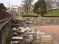
Middle part of the amphitheater
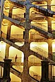
Stairway to the Cour des Voraces

Place du Forez and Saint-Polycarpe church

Ship of the Église Saint-Bruno-les-Chartreux de Lyon
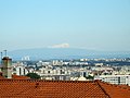
The Mont Blanc from les pentes de la Croix-Rousse seen from


See also
Individual evidence
- ↑ François Dallemagne: Les Défenses de Lyon. Enceintes et fortifications. Photographies de Georges Fessy. Éditions Lyonnaises d'Art et d'Histoire et al., Lyon et al. 2006, ISBN 2-84147-177-2 , pp. 42-50.
Coordinates: 45 ° 46 ' N , 4 ° 50' E