Persailhorn
| Persailhorn | ||
|---|---|---|
|
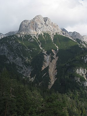
Persailhorn from the east |
||
| height | 2347 m above sea level A. | |
| location | Salzburg , Austria | |
| Mountains | Steinernes Meer , Berchtesgaden Alps | |
| Dominance | 0.5 km → Mitterhorn | |
| Notch height | 89 m ↓ Scharte to Mitterhorn | |
| Coordinates | 47 ° 27 '36 " N , 12 ° 53' 28" E | |
|
|
||
| rock | Banked Dachstein limestone | |
| Age of the rock | Norium - Rhaetium | |
| First ascent | June 12, 1887 by Heinrich Hess and Ludwig Purtscheller | |
The Persailhorn (also called Bersalhorn on some maps ) is 2347 m above sea level. A. high summit in the Steinerne Meer in the Berchtesgaden Alps .
Location and surroundings
The Persailhorn is located in the southwest of the massif as the first rocky summit of a side ridge high above the valley basin of Saalfelden . To the west is the mountain pine-covered Kienalkopf, on which the Peter-Wiechenthaler-Hütte stands. The Persailhorn is also the hut mountain of this Alpine Club hut. The Persailhorn borders the Mitterhorn in the northeast . The Persailhorn breaks off steeply and rocky on all sides.
Climbs
The Persailhorn can be reached from Wiechenthaler Hütte via two very well secured via ferratas (each with a level of difficulty BC or KS3C). The Südwandsteig leads in 2 hours through the partially exposed south flank and at the end over the south ridge to the summit. The newly created Wildentalsteig, which replaces the old normal route, leads through the north-west flank in a somewhat exposed route to the south ridge and via this to the summit in about 2 hours. The Saalfeldener Höhenweg , which connects the Persailhorn via Mitterhorn and Breithorn with the Riemannhaus via the ridge (approx. 3 hours from the Persailhorn) is marked, but only sparsely insured .
literature
- Bernhard Kühnhauser: Alpine Club Guide Berchtesgaden Alps with Hochkönig . 20th edition. Bergverlag Rother , Munich 2011, ISBN 978-3-7633-1127-9 , pp. 373-376 .


