Pigeon River (Lake Superior)
| Pigeon River | ||
|
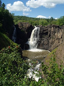
High falls |
||
| Data | ||
| Water code | US : 657824 | |
| location | Minnesota (USA), Ontario (Canada) | |
| River system | Saint Lawrence River | |
| Drain over | Saint Marys River → St. Clair River → Detroit River → Niagara River → Saint Lawrence River → Atlantic Ocean | |
| source |
Mountain Lake 48 ° 6 ′ 7 ″ N , 90 ° 17 ′ 51 ″ W. |
|
| muzzle | in the Upper Lake Coordinates: 47 ° 59 ′ 57 ″ N , 89 ° 34 ′ 10 ″ W 47 ° 59 ′ 57 ″ N , 89 ° 34 ′ 10 ″ W. |
|
| Mouth height |
183 m
|
|
| length | 80 km | |
| Left tributaries | Arrow River | |
| Flowing lakes | Mountain Lake , Moose Lake , North Fowl Lake , South Fowl Lake | |
| High Falls waterfall | ||
|
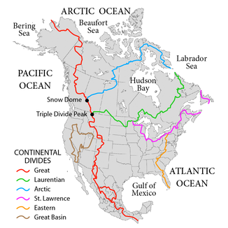
Continental watersheds in North America . The Laurentine watershed in green. |
||
The Pigeon River forms a section of the state border between the United States and Canada west of Lake Superior .
It runs in the US state of Minnesota and in the Canadian province of Ontario . In the pre-industrial age, the river was an important waterway for the transport and trade of furs.
geography
The Pigeon River leaves the Boundary Waters Canoe Area Wilderness in an easterly direction and reaches Lake Superior after 80 km. The Pigeon River is one of the larger tributaries of Lake Superior on its north bank.
Upper course
The Pigeon River has its origin in Mountain Lake . The Arrow River , which has its source in South Lake, is one of the tributaries of the Pigeon River . South Lake is only separated from North Lake by a narrow isthmus , which is part of the Rainy River catchment area . This isthmus is part of the Laurentine watershed and is crossed by the Height of Land Portage , which lies in the Rove Formation . Fur traders voyageurs and coureur des bois crossed this pass and traveled downstream the Rainy River and Winnipeg River to Lake Winnipeg , from where various trade routes led into the Canadian Northwest.
Lower course
Below South Fowl Lake , the Pigeon River alternates between navigable stretches and rapids and waterfalls. Near its mouth, the gradient gradually increases and culminates in a spectacular gorge with two well-known waterfalls: High Falls , the highest waterfall in Minnesota at 37 m, and Middle Falls . The canyon is located within Grand Portage State Park in Cook County , Minnesota, and in Pigeon River Provincial Park (9.49 km²) across the border in the Thunder Bay District of Ontario . The lower reaches also mark the northern border of the Grand Portage Indian Reservation .
The falls were circumvented first by Indians, then fur hunters and traders on a 9 mile portage from the river to the shores of Lake Superior. At the lakeshore and the beginning of this stretch known as the Grand Portage , fur trading companies set up a base that is now a memorial as the Grand Portage National Monument .
Web links
Individual evidence
- ↑ Northshore Info Lake Superios
- ↑ Eric Morse: Fur Trade Routes of Canada . NorthWord Press, Minoqua, WI 1979, ISBN 1-55971-045-4 , pp. 71-75.

