Winnipeg River
| Winnipeg River | ||
|
|
||
| Data | ||
| location | Ontario , Manitoba ( Canada ) | |
| River system | Nelson River | |
| Drain over | Nelson River → Hudson Bay | |
| origin |
Lake of the Woods 49 ° 46 ′ 18 " N , 94 ° 31 ′ 27" W. |
|
| Source height | 322 m | |
| muzzle | in the Winnipegsee coordinates: 50 ° 37 ′ 54 ″ N , 96 ° 19 ′ 13 ″ W 50 ° 37 ′ 54 ″ N , 96 ° 19 ′ 13 ″ W |
|
| Mouth height | 217 m | |
| Height difference | 105 m | |
| Bottom slope | 0.45 ‰ | |
| length | 235 km | |
| Catchment area | 106,500 km² | |
| Outflow at gauge Outflow from Lake of the Woods A Eo : 70,400 km² |
MQ 1892/2000 Mq 1892/2000 |
429 m³ / s 6.1 l / (s km²) |
| Discharge at the Slave Falls A Eo gauge : 125,000 km² |
MQ 1907/2000 Mq 1907/2000 |
850 m³ / s 6.8 l / (s km²) |
| Left tributaries | Whiteshell River , Whitemouth River | |
| Right tributaries | Black Sturgeon River , MacFarlane River , English River , Lee River , Bird River | |
| Small towns | Kenora | |
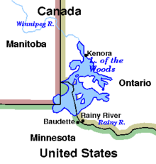
The Winnipeg River is a Canadian river that drains Lake of the Woods in the province of Ontario and flows into Lake Winnipeg in Manitoba .
The river runs over a length of 235 km from Norman Dam near Kenora to its confluence with Lake Winnipeg. Its catchment area covers 106,500 km², mainly in Canada. About 29,300 km² of this area is in northern Minnesota . Measured from the source of the Firesteel River , the Winnipeg River reaches a total length of 813 km.
geography
Along the course of the Winnipeg River are a number of lakes where the river widens. In Manitoba, that's Nutimik , Eleanor , Dorothy , Margaret , Natalie, and Lac du Bonnet . Lakes Nutimik , Dorothy and Margaret are entirely within Whiteshell Provincial Park . Lakes in Ontario that flow through are Gun , Roughrock, and Sand .
Tributaries of the Winnipeg River:
- Rainy River
- Black Sturgeon River
- English River
- Bird River
- Lee River
- Whiteshell River
- Whitemouth River
- MacFarlane River
Hydropower plants
There are several hydroelectric plants along the Winnipeg River. In the downstream direction these are:
| Surname | completion position |
Power [MW] |
Number of turbines |
hydraul. Potential [m] |
reservoir | operator |
|---|---|---|---|---|---|---|
| Norman | 1898-1926 | 14th | 5 | 6.4 | Lake of the Woods | AbitibiBowater |
| Kenora | 1906 / 1921-1926 | 10 | 10 | 6.4 | Lake of the Woods | AbitibiBowater |
| White Dog Falls | 1958 | 68 | 3 | n / A | n / A | OPG |
| Pointe du Bois | 1926 | 77 | 16 | 14th | n / A | Manitoba Hydro |
| Slave Falls | 1928-1948 | 67 | 8th | 9.75 | n / A | Manitoba Hydro |
| Seven Sisters | 1952 | 165 | 6th | 18.6 | n / A | Manitoba Hydro |
| McArthur | 1955 | 55 | 8th | 7th | Lac du Bonnet | Manitoba Hydro |
| Great Falls | 1928 | 136 | 6th | 17.7 | n / A | Manitoba Hydro |
| Pine Falls | 1952 | 89 | 6th | 11.3 | n / A | Manitoba Hydro |
The amount of runoff from the Winnipeg River is regulated by the Lake of the Woods Control Board .
Runoff level
- Winnipeg River at the West Branch Keewatin River Bridge gauge - hydrographic data from R-ArcticNET - gauge measurement 1907–1924
- Winnipeg River at the gauge above Grand du Bonnet Falls - hydrographic data from R-ArcticNET - gauge measurement 1911–1912
- Winnipeg River at the level below Lake of the Woods discharge - hydrographic data from R-ArcticNET - level measurement 1892–2000
- Winnipeg River at the gauge below Fourth Falls Seven Sisters - hydrographic data from R-ArcticNET - gauge measurement 1917–1919
- Winnipeg River at the Whitedog Falls Powerhouse gauge - hydrographic data from R-ArcticNET - gauge measurement 1913–1994
- Winnipeg River at the Slave Falls gauge - hydrographic data from R-ArcticNET - gauge measurement 1907–2000
- Winnipeg River at the Pine Falls Generating Station gauge - hydrographic data from R-ArcticNET - gauge measurement 1987–2000
- Winnipeg River at the McArthur Generating Station gauge - hydrographic data from R-ArcticNET - gauge measurement 1987–2000
- Winnipeg River at the gauge above Lamprey Falls - hydrographic data from R-ArcticNET - gauge measurement 1956–1963
- Winnipeg River at the gauge above Boundary Falls - hydrographic data from R-ArcticNET - gauge measurement 1928–1955
Web links
Individual evidence
- ↑ a b c The Atlas of Canada - Rivers ( Memento from January 22, 2013 in the Internet Archive ) (English)
- ↑ Winnipeg River at the level outflow from Lake of the Woods - hydrographic data from R-ArcticNET
- ↑ Winnipeg River at the Slave Falls gauge - hydrographic data from R-ArcticNET
- ↑ Manitoba Hydro - Generating Stations
- ↑ OPG - WHITEDOG FALLS STATION ( Memento from December 5, 2013 in the Internet Archive )
- ↑ Ontario Power Authority ( Memento from August 16, 2016 in the Internet Archive )
- ↑ Lake of the Woods Control Board (English) Lake of the Woods Control Board

