Pinhais
| Município de Pinhais "Terra dos pinheirais"
Pinhais
"Morada da Gralha-Azul" |
|||
|---|---|---|---|
|
Igreja de Nossa Senhora da Esperança (listed main church of Pinhais)
|
|||
|
|
|||
| Coordinates | 25 ° 26 ′ 41 ″ S , 49 ° 11 ′ 33 ″ W | ||
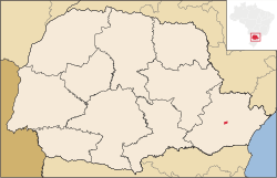
 Location of the municipality in the state of Paraná Location of the municipality in the state of Paraná
|
|||
| Symbols | |||
|
|||
| founding | City rights: March 20, 1992 (age 28) |
||
| Basic data | |||
| Country | Brazil | ||
| State | Paraná | ||
| ISO 3166-2 | BR-PR | ||
| structure | 1 district, 13 districts | ||
| height | 893 m | ||
| climate | subtropical, cfb | ||
| surface | 60.9 km² | ||
| Residents | 117.008 (2010) | ||
| density | 1,922.3 Ew. / km² | ||
| estimate | 132,157 (July 1, 2019) | ||
| Parish code | IBGE : 4119152 | ||
| Post Code | 83.323-000 | ||
| Telephone code | (+55) 41 | ||
| Time zone | UTC −3 | ||
| Website | pinhais.atende.net (Brazilian Portuguese) | ||
| politics | |||
| City Prefect | Marli Paulino Fagundes (2017–2020) | ||
| Political party | PDT | ||
| Culture | |||
| Patron saint | Maria as: Nossa Senhora da Boa Esperança | ||
| economy | |||
| GDP | 5,386,570 thousand. R $ 46,035,912 R $ per capita (2016) |
||
| HDI | 0.751 (high) (2010) | ||
Pinhais , officially Portuguese Município de Pinhais , a city in the Brazilian Paraná and belongs to the metropolitan area of Curitiba . According to an estimate by IBGE 2019, the city had 132,157 inhabitants on an area of 61 km². Until 1992 Pinhais was part of the municipality of Piraquara .
Pinhais is one of the smallest municipalities in the state of Paraná in terms of area with 19th place, but its economic performance took 11th place in 2016 with a gross social product for the municipality of R $ 5386.57 million out of 399 municipalities in the state.
The municipality is around 890 meters above sea level in the Mata Atlântica biome , the climate is Cfb according to the Köppen and Geiger climate classification .
Toponym
Pinhais has the city nickname Land of Pines because of the presence of araucaria forests and home of the azure raven (Gralha-azul). They are both listed in the city arms.
history
The territory of today's municipality of Pinhais shares the course of events during the settlement and development of the Curitiban plateau with the center of today's capital. Fundamental was the construction of the Curitiba-Paranguá railway line, which cuts through the region in an easterly direction.
The recent history of the Pinhais community is related to the urban settlement of Curitiba. With regard to Brazilian development policy from the mid-1950s, there was an enormous agricultural expansion in the north of the state of Paraná, initially with coffee plantations. In the 1960s and 1970s, the extraction of soy, wheat, corn and cotton expanded the acreage at a dizzying pace, especially in the New North and the southwest of the state, making Paraná the “granary of Brazil”.
This expansive agriculture, accompanied by cattle breeding for meat production, was based on mechanized agriculture, the formation of large estates and the reduction of labor. Farm workers, and even more so small farmers who were driven from the country, looked for opportunities to earn a living in the city. Many of the displaced landless people earned income in the metropolitan area as retailers or in transportation.
As a result, the municipality of Curitiba received population contingents from the interior of the country and from the neighboring state of Santa Catarina over the past three decades. Coupled with these phenomena, the urban land use control developed by the Municipality of Curitiba has increased land prices and centrifuged the lower-income population to the increasingly distant periphery. This process also reached the neighboring communities, including what is now the Pinhais community. Currently, Pinhais is one of the most industrialized communities in the state.
On November 19, 1964, the state created the administrative district of Pinhais, and on March 18, 1992, it gave it the status of a municipality, effective January 1, 1993.
railway station
The construction of the Curitiba-Paranaguá railway line influenced the formation of a small settlement in the vicinity of the station, where Pinhais is today. This station was possibly created due to the rail traffic with the São José dos Pinhais production center , a major producer of mate tea through the cultivation of yerba mate , wood and other goods. In the village of Pinhais, which has been growing since the inauguration of the Pinhais train station, mainly employees who had to maintain the railway line settled down.
At that time there was already a group of landowners who were cultivating plantings and raising animals to supply the consumption center of the nearby capital. These properties were located near the Rio Palmital, Atuba and Iraí.
Ceramics industry
In addition to the construction of the railway line and the opening of the Pinhais train station, the inauguration of a ceramic factory in mid-1885 also influenced the growth of this town. This company mainly supplied the region with bricks and roof tiles. In 1912, Guilherme Weiss bought the company from the Torres family and started developing the business. The new company imported new machines and increased its own production. With this modernization step, however, specialized workers were also required. For this, the company built a village for its employees. Warehouses for grain and other food were also built. Guilherme Weiss' heir, his son-in-law Humberto Scarpa, put ceramics production on hold in the mid-1960s and parceled out the property. This created many quarters that are now part of Pinhais. In the past, owners of large estates, some of which had become smaller due to hereditary division, had parcels carried out and sold properties to settlers who, from the middle of the 20th century, saw themselves forced to flee from the countryside due to the agricultural development processes described above. Several quarters of pinhais have names that can be traced back to the owners of the large estates, e.g. B. Maria Antonieta, Vila Amélia, Weissópolis e Emiliano Perneta.
Cement plant
In the early 1930s, a group of investors started a cement plant that came to be known as Indústria de Cimento Portland Paraná . They deliberately chose the location near Curitiba. In 1933, construction of the factory began on what is now the Pinhais area, along with 33 residential houses for the employees. Before and during the Second World War, Brazil tried to build up a basic industry (iron, cement industry, etc.), on the one hand to reduce dependence on agricultural exports and to promote the development of a Brazilian industrial park and on the other hand to reduce the import of industrial goods. But cement production was never started.
particularities
With the Autódromo Internacional de Curitiba, Pinhais has a 3.695 km long race track on which national and international car and motorcycle races of various classes are held. In addition, the Pinhais Expotrade is one of the largest convention and exhibition centers in the state.
education
In the community area, 20 community schools, 12 state schools, 11 children's centers and a faculty provide education for children and youth. In addition, around 600 students from the metropolis attend the international Swiss school Curitiba in Pinhais.
City structure
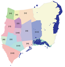
Pinhais forms a general district, the eponymous capital is divided into 13 districts (bairros):
- [1] Alphaville Graciosa; [2] Alto Tarumã; [3] Amelia; [4] Atuba; [5] Centro; [6] Cláudia; [7] Emiliano Perneta; [8] Estância Pinhais; [9] Maria Antonieta; [10] Pineville; [11] Planta Karla; [12] Vargem Grande and [13] Weissópolis.
Population development
| year | Residents | city | country |
|---|---|---|---|
| 1991 | 75,536 | 72,079 | 3,457 |
| 2000 | 102,985 | 100,726 | 2,259 |
| 2010 | 117.008 | 117.008 | 0 |
| 2019 | 132.157 | ? | ? |
 |
|||
Source: IBGE (2011)
Ethnic composition
Ethnic groups according to the statistical classification of the IBGE (as of 2010 with 117,008 inhabitants):
| group | proportion of | annotation |
|---|---|---|
| Brancos | 81,212 | (Whites, descendants of Europeans ) |
| Pardos (mixed race) | 30,675 | ( Mulatto , mestizo ) |
| Pretus | 4.119 | ( Blacks ) |
| Amarelos | 732 | (Asians) |
| Indigenous people | 271 | (indigenous population) |
Web links
- Website of the local government of Pinhais
- City Council website , Câmara Municipal (Brazilian Portuguese)
Individual evidence
- ↑ Pinhais climate: average temperature, weather by month, Pinhais weather averages - Climate-Data.org. In: de.climate-data.org. Retrieved November 24, 2019 .
- ↑ a b c Pinhais - Panorama. In: cidades.ibge.gov.br. IGBE , accessed November 24, 2019 (Brazilian Portuguese).
- ↑ Marly Paulino 12 (Prefeita). In: todapolitica.com. Eleições 2016, accessed November 24, 2019 (Brazilian Portuguese).
- ↑ Pinhais - Produto Interno Bruto dos Municípios. In: cidades.ibge.gov.br. IGBE , accessed November 24, 2019 (Brazilian Portuguese).
- ↑ Formação do povoado. In: Município de Pinhais. Retrieved March 24, 2020 (Brazilian Portuguese).
- ↑ História - O melhor do bairro de Pinhais, PR. Retrieved March 26, 2020 (Brazilian Portuguese).
- ↑ a b c História - A urbanização. Prefeitura de Pinhais, accessed March 29, 2020 (Brazilian Portuguese).
- ↑ Pinhais. In: pt: Wikipedia. Retrieved March 29, 2020 (Portuguese).
- ↑ Pinhais community: Website of the Pinhais community. Retrieved November 24, 2019 (Brazilian Portuguese).
- ↑ Evolução da divisão territorial do Brasil 1872-2010 (= IBGE [Ed.]: Documentos para disseminação. Memória institucional . No. 17 ). 2011, ISBN 978-85-240-4208-9 , ISSN 0103-6459 , Evolução da população, segundo os municípios - 1872/2010 (Brazilian Portuguese, ibge.gov.br [PDF; 122.3 MB ; accessed on March 29, 2020]).
- ↑ Tabela 2093: População residente por cor ou raça, sexo, situação do domicílio e grupos de idade - Amostra - Características Gerais da População. In: gov.br. Retrieved on March 29, 2020 (Brazilian Portuguese, database query with search terms “Pinhais (PR)” and “cor ou raça”).


