
Piraquara
| Município de Piraquara Piraquara |
|||
|---|---|---|---|
 Historical center
|
|||
|
|||
| Coordinates | 25 ° 27 ′ S , 49 ° 4 ′ W | ||
 Location of the municipality in the state of Paraná Location of the municipality in the state of Paraná
|
|||
| Symbols | |||
|
|||
| founding | 29th January 1890 (Vila) (130 years old) | ||
| Basic data | |||
| Country | Brazil | ||
| State | Paraná | ||
| ISO 3166-2 | BR-PR | ||
| Metropolitan area | Curitiba | ||
| height | 897 m | ||
| climate | tropical, cfb | ||
| surface | 227 km² | ||
| Residents | 93,207 (2010) | ||
| density | 410.5 Ew. / km² | ||
| estimate | 113,036 (July 1, 2019) | ||
| Parish code | IBGE : 4119509 | ||
| Post Code | 83301-000 | ||
| Telephone code | (+55) 41 | ||
| Time zone | UTC −3 | ||
| Website | piraquara.pr (Brazilian Portuguese) | ||
| politics | |||
| City Prefect | Marcus Mauricio de Souza Tesserolli (2017–2020) | ||
| Political party | PDT | ||
| economy | |||
| GDP | 1,133,372 thousand R $ 10,679 R $ per person (2016) |
||
| HDI | 0.700 (high) (2010) | ||


Piraquara , officially Portuguese Município de Piraquara , is a city in the Brazilian state of Paraná in the Sul region . In the 2010 census, the population was 93,207 Piraquarese . As of July 1, 2019, the population was estimated at 113,036 inhabitants, who live in a community area of around 227 km². It is part of the metropolitan region of Curitiba , the distance to the capital Curitiba is 22 km.
history
Before the arrival of the Europeans, the country was originally the summer residence of the Carijó Indians who otherwise lived on the coasts . Around 1660, Bandeirantes , mainly from the area of São Vicente and São Paulo , invaded the country in search of gold that had been found in some places as alluvial gold , many moved on to the more productive Minas Gerais after new gold discoveries there. These areas later also became settlement centers of cities like Curitiba, São José dos Pinhais or Piraquara. Several smaller fazendas had formed, which became known collectively as a settlement under the name of Piraquara. The word piraquara comes from the Tupi language and means fish hoard or fish eater, depending on how the root of the word is deciphered. Little progress was made until about the middle of the 19th century. After the arrival of Tyrolean immigrants from 1878 and the inauguration of the Estrada de Ferro do Paraná railway line in 1885, which connected the coast of Paraná with Curitiba, the community developed economically. Larger quantities of logging from the rich araucarias forests could now also be transported via the train station in Piraquara . Another economic mainstay of the community was the stone quarrying, it is symbolized today as a stone tower in the city coat of arms. Administratively it belonged to the municipality of São José dos Pinhais until its independence , on August 29, 1890 the place was raised to a vila under the new name Vila de Deodoro as a tribute to the president Manuel Deodoro da Fonseca . On April 10, 1929 the place was renamed from Deodoro to Piraquara.
The independent municipalities Campina Grande do Sul , formerly called Timbu, and Pinhais emerged from Piraquara , they were previously districts.
Novo Tirol
In 1878, 59 Italian-speaking families from Trentino-South Tyrol arrived , around 350 people, and founded the agricultural colony Colonia Imperial Santa Maria do Novo Tirol da Boca da Serra . Viticulture developed from the vines brought along.
The tourist route Caminho Trentino is reminiscent of the Tyroleans, and there are also several town partnerships.
geography
Surrounding communities are Quatro Barras in the north, São José dos Pinhais in the south, Morretes in the east and Pinhais in the west .
The predominant biome is Mata Atlântica .
In the north of the municipality is the Represa do Iraí reservoir , in the south the Represa Piraquara I and II reservoirs .
climate
The community has a tropical temperate climate, Cfb according to the Köppen and Geiger climate classification . The average temperature is 17.0 ° C. The average rainfall is 1565 mm per year.
Local government
The executive rests with the city prefect (mayor). In the local elections in 2016 , Marcus Mauricio de Souza Tesserolli of the Partido Democrático Trabalhista (PDT) was elected city prefect for the term from 2017 to 2020.
The legislature lies with a 13-member elected city council, the vereadores of the Câmara de Vereadores.
Since 1992, the community has consisted of a single district.
Population development
In 2010 around 27.3% of the population were children and young people up to the age of 15.
| year | Residents | city | country |
|---|---|---|---|
| 1991 | 31,346 | 19,359 | 11,987 |
| 2000 | 72,886 | 33,829 | 39,057 |
| 2010 | 93.207 | 45,738 | 47,469 |
| 2019 | 113.036 | ? | ? |
 |
|||
Source: IBGE (2011)
Average income and standard of living
In 2017, the average monthly income was 2.5 times the Brazilian minimum wage ( Salário mínimo ) of R $ 880.00 (income converted for 2019: around € 498 per month). The Human Development Index (HDI) is rated high at 0.700 for 2010.
In 2017, 9,469 people or 8.8% of the population were registered as permanently employed; 34.1% of the population had an income of half the minimum wage in 2010.
| HDI | ||||
|---|---|---|---|---|
| year | Points | |||
| 1991 | 0.478 | |||
| 2000 | 0.581 | |||
| 2010 | 0.700 | |||
The gross national product per capita was R $ 10,678.89 in 2016, the community's gross national product was around R $ 1,133.37 million.
Ethnic composition
Ethnic groups according to the statistical classification of the IBGE (status 2000 with 72,886 inhabitants, status 2010 with 93,297 inhabitants):
| group | Share 2000 |
Share 2010 |
annotation |
|---|---|---|---|
| Brancos | 52,287 | 61,213 | Whites, descendants of Europeans |
| Pardos | 17,085 | 27,732 | Mixed races, mulattos , mestizos |
| Pretus | 3,350 | 3,506 | black |
| Amarelos | 31 | 450 | Asians |
| Indigenous people | 496 | 306 | indigenous population |
| without specification | 637 | - |
Pictures from Piraquara

Igreja Matriz Senhor Bom Jesus dos Passos

Buildings in the historic center

Former train station
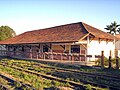
Former warehouse by the train station


Web links
- City Prefecture website (Brazilian Portuguese)
- Website of the Câmara Municipal (Brazilian Portuguese)
Individual evidence
- ↑ a b c Piraquara - Panorama. In: cidades.ibge.gov.br. IBGE , accessed November 24, 2019 (Brazilian Portuguese).
- ^ Eduardo de Almeida Navarro: Método Moderno de Tupi Antigo. 3. Edition. Global Editora, São Paulo 2005, p. 463.
- ↑ Piraquara climate: average temperature, weather by month, Piraquara weather averages - Climate-Data.org. In: de.climate-data.org. Retrieved November 24, 2019 .
- ^ Professor Marquinhos 12 (Prefeito). In: todapolitica.com. Eleições 2016, accessed November 24, 2019 (Brazilian Portuguese).
- ↑ Vereadores Eleitos em Piraquara. In: todapolitica.com. Eleições 2016, accessed November 24, 2019 (Brazilian Portuguese).
- ↑ Atlas do Desenvolvimento Humao no Brasil: Piraquara, PR . Retrieved November 24, 2019 (Brazilian Portuguese)
- ↑ Piraquara - Panorama - Trabalho e rendimento. In: cidades.ibge.gov.br. IBGE , accessed November 24, 2019 (Brazilian Portuguese).
- ↑ Piraquara - Produto Interno Bruto dos Municipios. In: cidades.ibge.gov.br. IBGE , accessed November 24, 2019 (Brazilian Portuguese).
- ↑ IBGE : Sistema IBGE de Recuperação Automática - SIDRA: Tabela 2093. Accessed on November 24, 2019 (Portuguese, database query, search terms Piraquara (PR) and Cor ou raça).