
Plauerhagen
|
Plauerhagen
Barkhagen municipality
Coordinates: 53 ° 29 ′ 47 " N , 12 ° 12 ′ 25" E
|
||
|---|---|---|
| Incorporation : | June 13, 2004 | |
| Postal code : | 19395 | |
| Area code : | 038735 | |
Location of Plauerhagen in Mecklenburg-Western Pomerania |
||

Plauerhagen is a district of the municipality of Barkhagen in the east of the Ludwigslust-Parchim district in Mecklenburg-Western Pomerania .
The Rauenberger Moor wetland is located south of Plauerhagen . The Penzliner See and Daschower See lie to the northwest, the Plauer See lies to the east. The Müritz-Elde waterway and the B 191 run south .
The Plauerhagen wind farm is about one kilometer east of the town. It consists of a total of 20 wind turbines of different types.
Plauerhagen was first mentioned in a document on August 3, 1235. On June 13, 2004, the communities Plauerhagen and Barkow merged to form the Barkhagen community.
Attractions
- Village church from 1784 timbered with brick and a roof turret -Türmchen
- War memorial 1914/18
- Blush oak with a memorial stone from 1913
→ See also the list of architectural monuments in Barkhagen # Plauerhagen

Plauerhagen village church

War memorial 1914-18
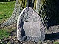
Blücher memorial stone and oak

.jpg)
.jpg)
literature
- Hildegard von Zastrow: The farming village of Plauerhagen from its first mention in 1235 to 1990 , publisher: Gemeindeverwaltung Barkhagen, Barkhagen 2014 (without ISBN)
- Fred Ruchhöft : The development of the cultural landscape in the Plau-Goldberg area in the Middle Ages. (= Rostock studies on regional history. Volume 5). Rostock 2001, ISBN 3-935319-17-7