
Pliska
| Pliska (Плиска) | |||
|
|||
| Basic data | |||
|---|---|---|---|
| State : |
|
||
| Oblast : | Shumen | ||
| Residents : | 853 (December 31, 2016) | ||
| Coordinates : | 43 ° 22 ' N , 27 ° 7' E | ||
| Height : | 145 m | ||
| Postal code : | 9920 | ||
| Telephone code : | (+359) 05323 | ||
| License plate : | H | ||
| administration | |||
| Mayor : | Christo Christow | ||


Pliska [ ˈpliskɐ ] ( Bulgarian Плиска ), also Ak Baba , Pliskow or Aboba is a former capital of the Bulgarian Empire and today a village in northeastern Bulgaria , in the Shumen Oblast , in the municipality of Kapitscha, near the cities of Novi Pasar and Kaspichan .
The remains of the old Bulgarian capital of the First Bulgarian Empire are now an archaeological excavation site and are located 7 km west of Novi Pasar in the Shumen Oblast . Today's Pliska has 853 inhabitants (2016), is 140 m high and about 2 km south of the ruins of the former capital of Bulgaria. After Sofia is 404 km away.
history
Pliska was the capital of the First Bulgarian Empire .
According to older historical ideas, it was founded by Khan Asparuch around 680 and was the capital until 893, when it had to cede this function to Preslaw .
According to recent historical and archaeological studies, the city of Oglos , conquered by Asparuch around 680, at the mouth of the Danube, could have been the first capital of the First Bulgarian Empire. In addition, there are no written documents about Pliska before the 9th century. However, Oglos has not yet been located.
The thesis of an early medieval wandering principality has been considered for a long time , according to which the Bulgarian court settled in different places of its dominion depending on requirements. Some historians see early medieval Bulgaria as a union state , i.e. as a domain that was based on a mutual, personal relationship of dependence between the ruler and his vassals and was not an institutional land state .
In addition to the schools of Preslaw and Ohrid , the school of Pliska was one of the spiritual universities of the Bulgarian Empire. In 811 the Byzantines suffered a heavy defeat at the Battle of Pliska .
The 27 km² large city was in the middle of a hilly landscape, which offers no natural protection, which was rather unusual at the time. It was surrounded by three rings of defense. The outermost consisted of a ditch system, the second of 9 to 12 m high stone walls and the innermost of clay bricks.
Historians see three distinctive urban development stages in the development of the city. The first wooden palace may date from the time of Khan Asparuch or his son Terwel . A hundred years later, under Khan Krum , the city experienced a major expansion . At that time, a new palace with a large water reservoir and modern baths, as well as a sophisticated system of underground secret passages, was built.
Pliska's first consideration by name is found in an inscription erected in 822 under Khan Omurtag . Under Omurtag, the city experienced a building boom. During this time Pliska experienced its heyday and covered a larger area than Constantinople . Particularly noteworthy are the new fortress walls built from solid stone blocks with towers, the Small Palace with the living rooms for the noble families, modern heated baths as well as two pagan temples and a throne room. The main place of worship of the Bulgarian Empire was the Madara rocky plateau not far from Pliska. A relief of a rider killing a lion with his spear can be seen on the steep rock (see Madara rider ). Near the relief, many khans report from the 8th / 9th centuries. Century in long inscriptions on stone about their triumphs against Byzantium.
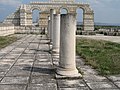
The third stage took place at the time of Christianization and is mainly characterized by the construction of the great basilica . The pupils of Cyril and Methodius, who had fled from Great Moravia , were probably received here in 886 by Prince Boris I , who founded a forerunner of the Preslav school here .
It is not known why the capital was moved by Boris I from Pliska to Preslaw in 893 . Possibly the old pagan "legacy" of the city and the persistent resistance of the old nobility against Christianization played a role.
- See also: First Bulgarian Empire , Proto- Bulgarians , Battle of Pliska , List of the rulers of Bulgaria
ruins
The ruins of Pliska were used as a quarry throughout the Middle Ages until the end of the 19th century. The stones from Pliska were used to build the Tombul Mosque (1740) in Shumen and the Turkish fortress of Varna , which was built from 1830 to 1834 after the Russians destroyed the medieval fortress near Varna.
The stones were brought 80 km to Varna by horse and cart along the old Roman road, which was preserved until the middle of the 20th century.
After the liberation of Bulgaria from the Turks in the Russo-Ottoman War (1877–1878), the fortress had to be completely demolished according to the Berlin Treaty (1878) . The castle's citadel was the last to be removed (1908). The stones were then used to build the Dormition of the Cathedral of Our Lady in Varna in 1896 , as well as the two high schools.
When these buildings were built in the 1880s, the importance of Pliska was not yet known, as the Shkopril brothers did not identify the ruins near the village of Aboba (bulg. Абоба) as the first Bulgarian capital Pliska until the 1890s.
photos
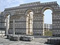
Old basilica
Old basilica
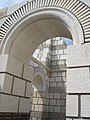
Old basilica, fragment

Old basilica, model


literature
- Daniel Ziemann: Pliska and the Bulgarian ethnogenesis in the early Middle Ages , In: Angelika Lauhus (Hrsg.): Bulgaria between Byzantium and the West. Contributions to culture, history and language - Symposium January 23, 2007 (= ZOE. Series of publications of the Center for Eastern Europe , Vol. 1), 2nd, revised and expanded edition, Kirsch-Verlag, Nümbrecht 2008, ISBN 978-3-933586-62 -9 , pp. 9-42.
Web links
- http://kodeks.uni-bamberg.de/Bulgaria/Pliska.htm
- http://www.kroraina.com/pliska/
- Материалы для болгарских древностей. Абоба-Плиска. - Известия Русского археологического института в Константинополе. Т. Х (1905) (PDF; 17.1 MB)