
Prakasam (district)
| Prakasam | |
|---|---|

|
|
| State | Andhra Pradesh |
| Administrative headquarters : | Ongols |
| Area : | 17,626 km² |
| Residents : | 3,392,764 (2011) |
| Population density : | 192.5 inhabitants / km² |
| Website : | Official website of the district |
Prakasam ( Telugu : ప్రకాశం జిల్లా) is one of 13 districts in the Indian state of Andhra Pradesh . The administrative seat is the city of Ongole .
geography
The district is located in the southeastern part of Andhra Pradesh . It is framed in the west by the district of Kurnool , in the northwest by the district of Mahbubnagar in the state of Telangana , in the north by the district of Guntur , in the east by the Gulf of Bengal and in the south by the districts of Sri Potti Sriramulu Nellore and YSR .
The district has an area of 17,626 km² and is one of the largest districts in Andhra Pradesh in terms of area. Of the area, 4425 km² (25.1 percent) are forested. The most important rivers in the district are Gundalakamma, Musi, Manneru and Paleru.
climate

The district's climate is characterized by hot summers and is generally dry, except during the monsoons. March to May is summer time with great drought and high temperatures. The southwest monsoon from the second week of June to the second week of October brings heavy rain. The following northeast monsoon until the end of December brings about the same amount of rain. The months of January and February are winter with cooler temperatures. The long-term average rainfall is 871 mm per year. The amount of precipitation increases from west to east. The southwest monsoon brings 388 mm and the northeast monsoon 393 mm. Otherwise there will be little rain. This leads to the drying up of the cultivated areas in the dry season, which lasts from January to May. The coldest month is December (average 23.46 ° - daily minimum 18 °, maximum 29 °), the warmest May (average 33.22 ° - minimum 27 °, maximum 39 °). During the Mosun season there is a humidity of up to 80 percent. This falls to 30 percent in the dry period.
population
The last census in 2011 counted 3,392,764 inhabitants. 1,712,735 of these were men (50.5 percent) and 1,680,029 women. In 2001, the Dalit numbered 651,498 (21.3 percent) and the Adivasi 118,241 (3.9 percent) people. Of the total number of residents, 662,116 people (19.52 percent) lived in urban areas in 2011. The majority of the population of Prakasam District speaks Telugu . There are 1093 inhabited villages in the entire district.
Population of the district by confession
A clear majority of the population is Hindu. The only significant religious minority are the Muslims with just over 6 percent of the population. The Christians form a smaller minority. The following table shows the exact religious composition of the population:
| year | Buddhists | Christians | Hindus | Jainas | Muslims | Sikhs | Other | not specified | Total | |||||||||
|---|---|---|---|---|---|---|---|---|---|---|---|---|---|---|---|---|---|---|
| number | % | number | % | number | % | number | % | number | % | number | % | number | % | number | % | number | % | |
| 2001 | 135 | 0.00% | 32,674 | 1.07% | 2,825,681 | 92.36% | 26th | 0.00% | 195,637 | 6.39% | 290 | 0.01% | 78 | 0.00% | 4,902 | 0.16% | 3,059,423 | 100.00% |
| Source: 2001 India Census | ||||||||||||||||||
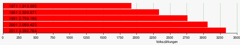
Population development
As everywhere in India, the population in the Prakasam district has been growing rapidly for decades. The increase was 10.9 percent between the last two censuses and is still significant in absolute terms. From 2001 to 2011 the population increased by over 330,000 people. The following table shows the exact numbers:
Significant places
The most populous town in the district is the main town Ongole with almost 290,000 residents. Other important cities with over 50,000 inhabitants are Chirala , Markapur and Kandukur .

economy
The majority of the population is employed in agriculture. The main crops are rice, sorghum (sorghum), turmeric , corn, pigeon peas , cotton, sugar cane, sesame and chilli. In addition, fishing is an important industry. There are numerous small industrial companies in various branches throughout the district. In the cities, people live from trading in goods and services.
history
The district was created on February 2, 1970 from parts of the then Guntur, Kurnool and Nellore districts under the name of Ongole District . The district was given its current name on May 12, 1972 in honor of T. Prakasam Panthulu , a companion of Gandhi and a fighter for the state of Andhra Pradesh.
administration
The Prakasam district comprises 56 mandals (talukas) and 1093 inhabited villages.
Fiscally, the district is now divided into the three tax districts of Kandukur, Markapur and Ongole.
Web links
- official website of Prakasam district
- The Prakasam District on Glorious India
- general information about the district
- Precipitation levels 2006-2010
- District map
- Map of the main streets of the district
- Map of the rivers
- Map of the rivers
- Map of the railway lines
- another map of the district
- First results of the 2011 census
Individual evidence
- ↑ http://censusindia.gov.in/2011census/maps/administrative_maps/INDIA2011.pdf
- ↑ Archived copy ( memento of the original from October 24, 2013 in the Internet Archive ) Info: The archive link was inserted automatically and has not yet been checked. Please check the original and archive link according to the instructions and then remove this notice. Forest Report, page 3
- ↑ Climate in the main town
- ↑ Climate-average rainfall, page 1 ( Memento of the original from January 24, 2013 in the Internet Archive ) Info: The archive link was inserted automatically and has not yet been checked. Please check the original and archive link according to the instructions and then remove this notice. (PDF; 460 kB)
- ↑ Climate-average rainfall (PDF; 2.8 MB)
- ↑ Data on the climate
- ↑ Census of India 2001, Prakasam District (PDF; 54 kB)
- ↑ AP Online: Prakasam District ( Memento of the original from June 6, 2014 in the Internet Archive ) Info: The archive link was inserted automatically and has not yet been checked. Please check the original and archive link according to the instructions and then remove this notice.

Anantapur | Chittoor | East Godavari | Guntur | Krishna | Kurnool | Prakasam | Srikakulam | Sri Potti Sriramulu Nellore | Visakhapatnam | Vizianagaram | West Godavari | YSR
Coordinates: 15 ° 20 ' N , 79 ° 33' E