
Mahbubnagar (District)
| Mahbubnagar | |
|---|---|

|
|
| State | Telangana |
| Administrative headquarters : | Mahabubnagar |
| Area : | 18,432 km² |
| Residents : | 4,042,191 (2011) |
| Population density : | 219.3 inhabitants / km² |
| Website : | Official website of the district |
Mahbubnagar , also Mahabubnagar ( Telugu : మహబూబ్ నగర్ జిల్లా; Urdu : محبوب نگر ضلع) is a district in the Indian state of Telangana . The administrative seat is the city of Mahabubnagar .
geography
The district is located in the southwest of Telangana . It is framed in the west by the state of Karnataka , in the north by the district of Rangareddy , in the east by the district of Nalgonda and in the south by the state of Andhra Pradesh .
The district has an area of 18,432 km 2 . 3,033 km 2 (16.5%) of the area are forested. The main rivers in the district are the Krishna , Tungabhadra , Vendi, Peddavaagu and Chinnavaagu.
climate
The district's climate is characterized by hot summers and is generally dry, except during the monsoons. March to May is summer time with great drought and high temperatures. The southwest monsoon from the second week of June to the second week of October brings the most abundant rain. The subsequent northeast monsoon until the end of December brings somewhat lower, but still significant amounts of rain. The months of January and February are winter with cooler temperatures. The long-term average of rainfall in the district is only 692 mm per year. The district is one of the areas with the lowest rainfall in Andhra Pradesh. The southwest monsoon brings 519 mm and the northeast monsoon 114 mm of the annual rainfall. Otherwise there will be little rain. This leads to the drying up of the cultivated areas in the dry season, which lasts from January to May. The coldest month is December (average 22.72 ° - daily minimum 17 °, maximum 29 °), the warmest May (average 32.56 ° - minimum 26 °, maximum 39 °). During the monsoon season there is a humidity of up to 80 percent. This falls to 30 percent in the dry period.
population
The last census in 2011 counted 4,042,191 inhabitants. Of these, 2,046,247 were men (50.1 percent) and 1,995,944 women. In 2001 the Dalit numbered 600,927 (17.1 percent) and the Adivasi 278,709 (7.9 percent) people. Of the total number of residents, 606,423 people (15 percent) lived in urban areas in 2011. The majority of the population of Mahbubnagar District speaks Telugu . Other important languages are Urdu and Hindi . There are 1,475 inhabited villages throughout the district.
Population of the district by confession
A clear majority of the population is Hindu. The only significant religious minority are the Muslims with just over 8 percent of the population. The Christians form a smaller minority. The following table shows the exact religious composition of the population:
| year | Buddhists | Christians | Hindus | Jainas | Muslims | Sikhs | Other | not specified | Total | |||||||||
|---|---|---|---|---|---|---|---|---|---|---|---|---|---|---|---|---|---|---|
| number | % | number | % | number | % | number | % | number | % | number | % | number | % | number | % | number | % | |
| 2001 | 32 | 0.00% | 18,800 | 0.54% | 3,193,932 | 90.89% | 26th | 0.00% | 296.975 | 8.45% | 254 | 0.01% | 84 | 0.00% | 3.831 | 0.11% | 3,513,934 | 100.00% |
| Source: 2001 India Census | ||||||||||||||||||
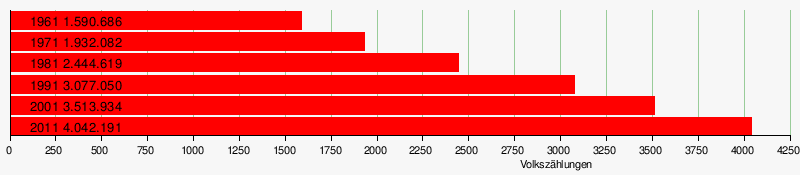
Population development
As everywhere in India, the population in the Mahbubnagar district has been growing rapidly for decades. The increase was just under 15 percent between the last two censuses and is still significant in absolute terms. From 2001 to 2011 the population increased by nearly 530,000 people. The following table shows the exact numbers:
Significant places
The most populous town in the district is the main town of Mahabubnagar with around 130,000 residents. Other important cities with over 50,000 inhabitants are Gadwal and Wanaparti .

economy

The majority of the population is employed in agriculture. Mainly carrot millet (sorghum), rice, cotton, corn, pigeon peas , peanuts and sugar cane are grown. In addition, hand weaving is an important branch of business. There is little industry. Various types of rock (limestone, granite, etc.) and sand, which are used industrially, are found in natural resources. In the cities, people live from trading in goods and services.
history
Mahbubnagar is part of the Telangana region and shares its history. The district belongs to the land of the Cholas, "Cholawardi". The district and capital were given their current name on December 4, 1890 in honor of Mir Mahbub Ali Khan Asaf Jah VI, the then Nizab of Hyderabad. Until 1956, the area was a region in Hyderabad State. Thereafter Mahbubnagar became an administrative unit within the then newly created state of Andhra Pradesh . Mahbubnagar came to Telangana state after it was separated.
administration
The Mahbubnagar district comprises 64 mandals (talukas) and 1,475 inhabited villages.
Politically, the district is now divided into the five tax districts of Gadwal, Mahabubnagar, Nagar Karnul, Narayanpet and Wanaparti.
Web links
- official website of Mahbubnagar district
- The Mahbubnagar District on Glorious India
- general information about the district
- Precipitation levels 2006-2010
- District map
- Map of the main streets of the district
- Map of the rivers
- Map of the rivers
- Map of the railway lines
- another map of the district
- First results of the 2011 census
Individual evidence
- ↑ http://censusindia.gov.in/2011census/maps/administrative_maps/INDIA2011.pdf
- ↑ Archived copy ( memento of the original from October 24, 2013 in the Internet Archive ) Info: The archive link was inserted automatically and has not yet been checked. Please check the original and archive link according to the instructions and then remove this notice. Forest Report, page 3
- ↑ Climate in the main town
- ↑ Climate-average rainfall, page 1 ( Memento of the original from March 18, 2013 in the Internet Archive ) Info: The archive link was inserted automatically and has not yet been checked. Please check the original and archive link according to the instructions and then remove this notice. (PDF file; 447 kB)
- ↑ Information on climate and water ( Memento of the original dated May 2, 2012 in the Internet Archive ) Info: The archive link was inserted automatically and has not yet been checked. Please check the original and archive link according to the instructions and then remove this notice. (PDF file; 2.72 MB)
- ↑ Data on the climate
- ↑ Census of India 2001 (PDF; 53 kB)
- ↑ AP Online: Mahbubnagar District ( Memento of the original from March 14, 2016 in the Internet Archive ) Info: The archive link was inserted automatically and has not yet been checked. Please check the original and archive link according to the instructions and then remove this notice.

Districts as of 2016 (31 districts)
Adilabad |
Bhadradri Kothagudem |
Hyderabad |
Jagtial |
Jangaon |
Jayashankar Bhupalapally |
Jogulamba Gadwal |
Kamareddy |
Karimnagar |
Khammam |
Kumaram Bheem |
Mahabubabad |
Mahabubnagar |
Mancherial |
Medak |
Medchal – Malkajgiri |
Nagarkurnool |
Nalgonda |
Nirmal |
Nizamabad |
Peddapalli |
Rajanna Sircilla |
Rangareddy |
Sangareddy |
Siddipet |
Suryapet |
Vikarabad |
Wanaparthy |
Warangal Rural |
Warangal Urban |
Yadadri Bhuvanagiri
districts until 2016 (10 districts)
Adilabad |
Hyderabad |
Karimnagar |
Khammam |
Mahbubnagar |
Medak |
Nalgonda |
Nizamabad |
Rangareddy |
Warangal